
Horsens fjord left
Eine Fahrradroute, die in Horsens, Region Mitteljütland, Dänemark beginnt.
Übersicht
Über diese Route
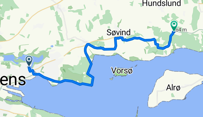
<p>Diese Route führt durch den Horsensfjord.</p>
<p>Im ersten Teil des Weges sind Sie nah am Meer, Sie können das Ufer sehen. Zuerst verlassen Sie die Häuser und treten dann in einen Wald ein, der Weg führt durch den Wald. Wenn der Wald endet, fahren Sie über das Land und der Rest des Weges ist im Feld, Sie passieren ein Dorf, das den Namen Sovind trägt.</p>
<p>Dieser Weg führt die gesamte Strecke entlang des Nationalradwegs 5. Sie finden einige Tische mit Bänken, um etwas auf diesem Weg zu sich zu nehmen!</p>
<p>Ich hoffe, Sie genießen diese Route.</p>
Übersetzt, Original anzeigen (Englisch)- -:--
- Dauer
- 18,8 km
- Distanz
- 130 m
- Aufstieg
- 113 m
- Abstieg
- ---
- Ø-Tempo
- ---
- Max. Höhe
Weiter mit Bikemap
Diese Radroute verwenden, bearbeiten oder herunterladen
Du möchtest Horsens fjord left fahren oder sie für deine eigene Reise anpassen? Folgendes kannst du mit dieser Bikemap-Route machen:
Gratis Funktionen
- Speichere diese Route als Favorit oder in einer Sammlung
- Kopiere & plane deine eigene Version dieser Route
- Synchronisiere deine Route mit Garmin oder Wahoo
Premium-Funktionen
Kostenlose Testversion für 3 Tage oder einmalige Zahlung. Mehr über Bikemap Premium.
- Navigiere diese Route auf iOS & Android
- Exportiere eine GPX / KML-Datei dieser Route
- Erstelle deinen individuellen Ausdruck (Jetzt kostenlos ausprobieren)
- Lade diese Route für die Offline-Navigation herunter
Entdecke weitere Premium-Funktionen.
Bikemap Premium aktivierenVon unserer Community
Horsens: Andere beliebte Routen, die hier beginnen
 Horsens-Sondrup Strand
- Distanz
- 17,1 km
- Aufstieg
- 124 m
- Abstieg
- 126 m
- Standort
- Horsens, Region Mitteljütland, Dänemark
 The butterflytrip / Sommerfugleruten ala Bjerge (Bjerre)
- Distanz
- 52,7 km
- Aufstieg
- 286 m
- Abstieg
- 289 m
- Standort
- Horsens, Region Mitteljütland, Dänemark
 Julestrail
- Distanz
- 57,2 km
- Aufstieg
- 208 m
- Abstieg
- 199 m
- Standort
- Horsens, Region Mitteljütland, Dänemark
 Rundt om Horsens
- Distanz
- 35,7 km
- Aufstieg
- 109 m
- Abstieg
- 109 m
- Standort
- Horsens, Region Mitteljütland, Dänemark
 firday
- Distanz
- 10,2 km
- Aufstieg
- 62 m
- Abstieg
- 66 m
- Standort
- Horsens, Region Mitteljütland, Dänemark
 Horsens - Aalborg
- Distanz
- 163,1 km
- Aufstieg
- 512 m
- Abstieg
- 519 m
- Standort
- Horsens, Region Mitteljütland, Dänemark
 Horsens fjord left
- Distanz
- 18,8 km
- Aufstieg
- 130 m
- Abstieg
- 113 m
- Standort
- Horsens, Region Mitteljütland, Dänemark
 Route in Horsens
- Distanz
- 121,3 km
- Aufstieg
- 897 m
- Abstieg
- 897 m
- Standort
- Horsens, Region Mitteljütland, Dänemark
In der App öffnen