

Bury St Edmunds Hilly Loop
Eine Fahrradroute, die in Bury St Edmunds, England, United Kingdom beginnt.
Übersicht
Über diese Route
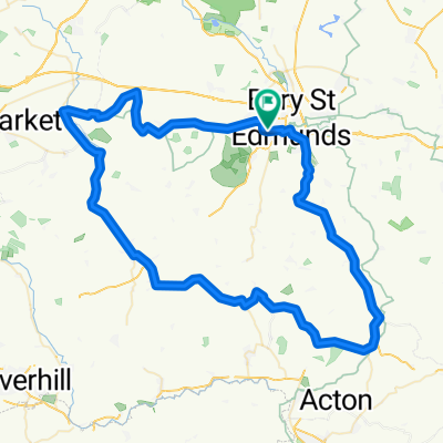
The first part of the route is one of the hilliest in Suffolk. Hartest Hill is the steepest. The route takes you down country roads through Lavenham and Bildeston before heading north through Ringshall to Stowmarket.
Go straight through the centre of Stowmarket and once out of Stowmarket follow the cycle path alongside the A14 to Haughley New Street. Although this cycle path is unpleasant and contains broken glass and some waste it would be suicidal going on the A14. Then follow the villages back into Stowmarket. There is a cycle path to the left just before you get into Bury. This cycle path is a lot nicer and gets you off the busy main road entering Bury.
If you do have problems then there are plenty of regular trains in the villages between Stowmarket and Bury.
- -:--
- Dauer
- 109,2 km
- Distanz
- 397 m
- Aufstieg
- 401 m
- Abstieg
- ---
- Ø-Tempo
- ---
- Ø-Tempo
Routenqualität
Wegtypen und Untergründe entlang der Route
Wegtypen
Straße
47,8 km
(44 %)
Vielbefahrene Straße
34,8 km
(32 %)
Untergründe
Befestigt
10,8 km
(10 %)
Unbefestigt
0,2 km
(<1 %)
Asphalt
9,9 km
(9 %)
Befestigt (undefiniert)
0,7 km
(<1 %)
Weiter mit Bikemap
Diese Radroute verwenden, bearbeiten oder herunterladen
Du möchtest Bury St Edmunds Hilly Loop fahren oder sie für deine eigene Reise anpassen? Folgendes kannst du mit dieser Bikemap-Route machen:
Gratis Funktionen
- Speichere diese Route als Favorit oder in einer Sammlung
- Kopiere & plane deine eigene Version dieser Route
- Synchronisiere deine Route mit Garmin oder Wahoo
Premium-Funktionen
Kostenlose Testversion für 3 Tage oder einmalige Zahlung. Mehr über Bikemap Premium.
- Navigiere diese Route auf iOS & Android
- Exportiere eine GPX / KML-Datei dieser Route
- Erstelle deinen individuellen Ausdruck (Jetzt kostenlos ausprobieren)
- Lade diese Route für die Offline-Navigation herunter
Entdecke weitere Premium-Funktionen.
Bikemap Premium aktivierenVon unserer Community
Bury St Edmunds: Andere beliebte Routen, die hier beginnen
 BSE Kentford Hargrave BSE loop
- Distanz
- 54,8 km
- Aufstieg
- 254 m
- Abstieg
- 254 m
- Standort
- Bury St Edmunds, England, Vereinigtes Königreich
 39k bury north
- Distanz
- 39,3 km
- Aufstieg
- 156 m
- Abstieg
- 156 m
- Standort
- Bury St Edmunds, England, Vereinigtes Königreich
 tour de bury smol
- Distanz
- 37 km
- Aufstieg
- 145 m
- Abstieg
- 144 m
- Standort
- Bury St Edmunds, England, Vereinigtes Königreich
 Wherstead circuit
- Distanz
- 17,6 km
- Aufstieg
- 130 m
- Abstieg
- 130 m
- Standort
- Bury St Edmunds, England, Vereinigtes Königreich
 27.6km
- Distanz
- 27,6 km
- Aufstieg
- 103 m
- Abstieg
- 103 m
- Standort
- Bury St Edmunds, England, Vereinigtes Königreich
 10km ride
- Distanz
- 9,6 km
- Aufstieg
- 54 m
- Abstieg
- 49 m
- Standort
- Bury St Edmunds, England, Vereinigtes Königreich
 BURY-LAVENHAM-WICKHAMBROOK-MOULTON-BURY
- Distanz
- 75 km
- Aufstieg
- 358 m
- Abstieg
- 358 m
- Standort
- Bury St Edmunds, England, Vereinigtes Königreich
 Kentford Circular
- Distanz
- 48,8 km
- Aufstieg
- 240 m
- Abstieg
- 239 m
- Standort
- Bury St Edmunds, England, Vereinigtes Königreich
In der App öffnen