

Dealership to Casitas Springs
Eine Fahrradroute, die in Ventura, Kalifornien, Vereinigte Staaten beginnt.
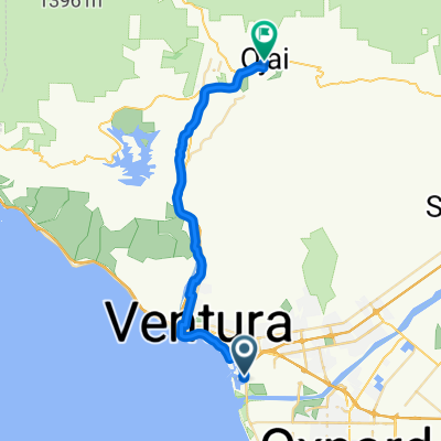
Übersicht
Über diese Route
Musste Arbeiten an meinem Auto erledigen lassen, also habe ich das Rad eingepackt und bin durch Ventura bis nach Casitas Springs (Foster Park) gefahren. Ich habe versucht, eine Route zu wählen, um den Highway 1 und den größten Teil von Olivas zu vermeiden, aber auf dem Hinweg musste ich etwa eine Meile neben den Bahngleisen entlangfahren, was auf einem Rennrad aus den 70ern ziemlich ruppig war. Das ließe sich vermeiden, wenn man einfach auf der Olivas bleibt, bis man zum Highway 1 kommt. Der Track sieht so aus, als ob ich neben den Bahngleisen gestartet wäre, aber wie üblich habe ich vergessen, mein GPS einzuschalten. Ich habe es mit Google Earth nachgebessert, aber der eigentliche Start war von der Autocenter Rd./Johnson Drive, die parallel zur 101 Freeway verläuft.
- -:--
- Dauer
- 49,5 km
- Distanz
- 163 m
- Aufstieg
- 163 m
- Abstieg
- ---
- Ø-Tempo
- 80 m
- Max. Höhe
Routenqualität
Wegtypen und Untergründe entlang der Route
Wegtypen
Radweg
23,3 km
(47 %)
Straße
10,9 km
(22 %)
Untergründe
Befestigt
31,2 km
(63 %)
Asphalt
27,2 km
(55 %)
Beton
2,5 km
(5 %)
Highlights der Route
POIs entlang der Route
Interessanter Ort nach 44,1 km
Actual start point
Weiter mit Bikemap
Diese Radroute verwenden, bearbeiten oder herunterladen
Du möchtest Dealership to Casitas Springs fahren oder sie für deine eigene Reise anpassen? Folgendes kannst du mit dieser Bikemap-Route machen:
Gratis Funktionen
- Speichere diese Route als Favorit oder in einer Sammlung
- Kopiere & plane deine eigene Version dieser Route
- Synchronisiere deine Route mit Garmin oder Wahoo
Premium-Funktionen
Kostenlose Testversion für 3 Tage oder einmalige Zahlung. Mehr über Bikemap Premium.
- Navigiere diese Route auf iOS & Android
- Exportiere eine GPX / KML-Datei dieser Route
- Erstelle deinen individuellen Ausdruck (Jetzt kostenlos ausprobieren)
- Lade diese Route für die Offline-Navigation herunter
Entdecke weitere Premium-Funktionen.
Bikemap Premium aktivierenVon unserer Community
Ventura: Andere beliebte Routen, die hier beginnen
 Vta Rincon
- Distanz
- 18,9 km
- Aufstieg
- 45 m
- Abstieg
- 50 m
- Standort
- Ventura, Kalifornien, Vereinigte Staaten
 casitas
- Distanz
- 67,5 km
- Aufstieg
- 589 m
- Abstieg
- 581 m
- Standort
- Ventura, Kalifornien, Vereinigte Staaten
 Venturaria
- Distanz
- 58,6 km
- Aufstieg
- 256 m
- Abstieg
- 256 m
- Standort
- Ventura, Kalifornien, Vereinigte Staaten
 Ventura to Ojai Bike Trail
- Distanz
- 49,9 km
- Aufstieg
- 352 m
- Abstieg
- 351 m
- Standort
- Ventura, Kalifornien, Vereinigte Staaten
 Ventura to Ojai
- Distanz
- 31,8 km
- Aufstieg
- 247 m
- Abstieg
- 24 m
- Standort
- Ventura, Kalifornien, Vereinigte Staaten
 Ventura - Ojai OK
- Distanz
- 79,5 km
- Aufstieg
- 566 m
- Abstieg
- 557 m
- Standort
- Ventura, Kalifornien, Vereinigte Staaten
 Ventura Cycling
- Distanz
- 35 km
- Aufstieg
- 151 m
- Abstieg
- 150 m
- Standort
- Ventura, Kalifornien, Vereinigte Staaten
 Dealership to Casitas Springs
- Distanz
- 49,5 km
- Aufstieg
- 163 m
- Abstieg
- 163 m
- Standort
- Ventura, Kalifornien, Vereinigte Staaten
In der App öffnen