

De Maasduinen National Park
Eine Fahrradroute, die in Arcen, Limburg, Niederlande beginnt.
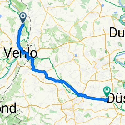
Übersicht
Über diese Route
On an elongated, high sand ridge between the Meuse and the German border, there are relatively young conifers and heather plants, which have been planted on what was once drifting sand. This sand has largely determined the appearance of the area; National Park "De Maasduinen" is a terraced landscape. The estate "de Hamert", as the area was called until 1998, forms the heart of the forest and heathland fields that cover approximately 45 hectares. Your tour also goes through an area called the Wellsche Heide. The starting point of the bike tour is on the Maas at Veerhuys Tante Jet, where you start the day with a cup of coffee or tea and apple pie. Then it is time to leave. The Maas determines the atmosphere during your bike ride. With the sound of the rippling water in the background, you can intensely enjoy all the beauty that the Maas and surrounding nature has to offer on this route.
- -:--
- Dauer
- 41,5 km
- Distanz
- 125 m
- Aufstieg
- 123 m
- Abstieg
- ---
- Ø-Tempo
- 30 m
- Max. Höhe

Routenqualität
Wegtypen und Untergründe entlang der Route
Wegtypen
Straße
12,5 km
(30 %)
Radweg
10,1 km
(24 %)
Untergründe
Befestigt
12,1 km
(29 %)
Unbefestigt
9,1 km
(22 %)
Asphalt
11,6 km
(28 %)
Loser Schotter
6,2 km
(15 %)
Weiter mit Bikemap
Diese Radroute verwenden, bearbeiten oder herunterladen
Du möchtest De Maasduinen National Park fahren oder sie für deine eigene Reise anpassen? Folgendes kannst du mit dieser Bikemap-Route machen:
Gratis Funktionen
- Speichere diese Route als Favorit oder in einer Sammlung
- Kopiere & plane deine eigene Version dieser Route
- Synchronisiere deine Route mit Garmin oder Wahoo
Premium-Funktionen
Kostenlose Testversion für 3 Tage oder einmalige Zahlung. Mehr über Bikemap Premium.
- Navigiere diese Route auf iOS & Android
- Exportiere eine GPX / KML-Datei dieser Route
- Erstelle deinen individuellen Ausdruck (Jetzt kostenlos ausprobieren)
- Lade diese Route für die Offline-Navigation herunter
Entdecke weitere Premium-Funktionen.
Bikemap Premium aktivierenVon unserer Community
Arcen: Andere beliebte Routen, die hier beginnen
 Von Arcen nach Marbeck
- Distanz
- 84,8 km
- Aufstieg
- 233 m
- Abstieg
- 191 m
- Standort
- Arcen, Limburg, Niederlande
 Arcen - Blietterswyk
- Distanz
- 23,8 km
- Aufstieg
- 82 m
- Abstieg
- 79 m
- Standort
- Arcen, Limburg, Niederlande
 Schandelo-Rote
- Distanz
- 20,1 km
- Aufstieg
- 50 m
- Abstieg
- 43 m
- Standort
- Arcen, Limburg, Niederlande
 Maas-Route
- Distanz
- 15,1 km
- Aufstieg
- 56 m
- Abstieg
- 58 m
- Standort
- Arcen, Limburg, Niederlande
 Von Lottum bis Afferden
- Distanz
- 28,8 km
- Aufstieg
- 61 m
- Abstieg
- 54 m
- Standort
- Arcen, Limburg, Niederlande
 Vom Graanbranderij de IJsvogel nach Kaarst
- Distanz
- 58,3 km
- Aufstieg
- 136 m
- Abstieg
- 114 m
- Standort
- Arcen, Limburg, Niederlande
 arcen
arcen- Distanz
- 18,2 km
- Aufstieg
- 62 m
- Abstieg
- 62 m
- Standort
- Arcen, Limburg, Niederlande
 Maas-Abend-Route
- Distanz
- 29,4 km
- Aufstieg
- 51 m
- Abstieg
- 49 m
- Standort
- Arcen, Limburg, Niederlande
In der App öffnen