

g) 03 FC Ciclovia del fiume Savio nord: da Cesena al Lido di Savio; River Savio cycle route from Cesena to the sea.
Eine Fahrradroute, die in Cesena, Emilia-Romagna, Italien beginnt.
Übersicht
Über diese Route
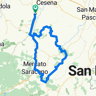
La ciclovia si sviluppa lungo il fiume Savio per la parte di pianura da Cesena al mare. Con le ultime realizzazioni ciclabili il percorso parte dall'area sud ovest del comune di Cesena in particolare da via Modena e arriva presso la foce del fiume in località lido di Savio nel comune di Ravenna.Il percorso attraversa l'abitato di Cesena nella parte ovest ed è ben raccordato con ciciabili urbane con la stazione ferroviaria Sono altresì presenti alcuni tratti su viabilità minore promiscua a basso traffico, per circa il 20% della lunghezza.
In realtà sono possibile escursioni sul fiume anche più a monte di via Modena con percorsi sterrati che sfruttano sia un ponte di ferro che due guadi attrezzati di cui uno armato con pietre praticabile solo con bici a mano. Il percorso è quasi tutto sull'argine del fiume con qualche passaggio su viabilità promiscua da praticare con attenzione. Il fondo stradale è prevalentemente sterrato con buona inghiaiatura compatta, ma bisognoso di manutenzione soprattutto con riferimento agli sfalci. E ' presente segnaletica di direzione peraltro da mettere a punto nella parte ravennate del percorso.
English
The cycle route runs along the Savio river in the part of the plain from Cesena to the sea. With the latest cycling achievements, the route starts from the southwestern area of the municipality of Cesena in particular from via Modena and arrives at the mouth of the river in Lido di Savio in the municipality of Ravenna. The route crosses the town of Cesena in the west and it is well connected by urban cycle paths to the railway station. There are also some sections on minor not segregated roads, for about 20% of the length. It is however possible to go on excursions on the river even further upstream from via Modena with dirt paths that take advantage of both an iron bridge and two equipped fords, one of which is armed with stones that can only be used by bikedismounting . The route is almost entirely on the river bank with some crossing on trafficked roads to be followed carefully. The road surface is mainly unpaved with good compact gravel, but in need of maintenance especially with reference to mowing. There is also direction signs that need to be improved in the Ravenna part of the route.
- -:--
- Dauer
- 34,7 km
- Distanz
- 14 m
- Aufstieg
- 61 m
- Abstieg
- ---
- Ø-Tempo
- 48 m
- Max. Höhe

Fotos von der Route
 03 FC Ciclovia del fiume Savio nord: da Cesena al Lido di Savio; River Savio cycle route from Cesena to the sea.\"")
 03 FC Ciclovia del fiume Savio nord: da Cesena al Lido di Savio; River Savio cycle route from Cesena to the sea.\"")
 03 FC Ciclovia del fiume Savio nord: da Cesena al Lido di Savio; River Savio cycle route from Cesena to the sea.\"")
 03 FC Ciclovia del fiume Savio nord: da Cesena al Lido di Savio; River Savio cycle route from Cesena to the sea.\"")
Routenqualität
Wegtypen und Untergründe entlang der Route
Wegtypen
Pfad
7,3 km
(21 %)
Ruhige Straße
6,9 km
(20 %)
Untergründe
Befestigt
10,4 km
(30 %)
Unbefestigt
19,4 km
(56 %)
Asphalt
10,4 km
(30 %)
Schotter
9,4 km
(27 %)
Highlights der Route
POIs entlang der Route
Interessanter Ort nach 3,6 km
Ponte di ferro ciclopedonale
Interessanter Ort nach 6 km
Punto da e per staziobe FS
Interessanter Ort nach 17,5 km
Passaggio alternativo
Interessanter Ort nach 25,2 km
inizio tratto erboso
Interessanter Ort nach 29 km
Prudenza sul ponte
Interessanter Ort nach 29,2 km
Percorso alternativo per Savio/Lido di Savio
Interessanter Ort nach 29,4 km
Percorso argone ds per MTB
Weiter mit Bikemap
Diese Radroute verwenden, bearbeiten oder herunterladen
Du möchtest g) 03 FC Ciclovia del fiume Savio nord: da Cesena al Lido di Savio; River Savio cycle route from Cesena to the sea. fahren oder sie für deine eigene Reise anpassen? Folgendes kannst du mit dieser Bikemap-Route machen:
Gratis Funktionen
- Speichere diese Route als Favorit oder in einer Sammlung
- Kopiere & plane deine eigene Version dieser Route
- Synchronisiere deine Route mit Garmin oder Wahoo
Premium-Funktionen
Kostenlose Testversion für 3 Tage oder einmalige Zahlung. Mehr über Bikemap Premium.
- Navigiere diese Route auf iOS & Android
- Exportiere eine GPX / KML-Datei dieser Route
- Erstelle deinen individuellen Ausdruck (Jetzt kostenlos ausprobieren)
- Lade diese Route für die Offline-Navigation herunter
Entdecke weitere Premium-Funktionen.
Bikemap Premium aktivierenVon unserer Community
Cesena: Andere beliebte Routen, die hier beginnen
 Seconda a Cesenatico
- Distanz
- 49,2 km
- Aufstieg
- 488 m
- Abstieg
- 479 m
- Standort
- Cesena, Emilia-Romagna, Italien
 Centro Cesena - Mercato Saraceno
- Distanz
- 25,6 km
- Aufstieg
- 355 m
- Abstieg
- 241 m
- Standort
- Cesena, Emilia-Romagna, Italien
 Giro Donne
- Distanz
- 31,9 km
- Aufstieg
- 510 m
- Abstieg
- 510 m
- Standort
- Cesena, Emilia-Romagna, Italien
 Bicipace 2011 - 5 - Cesena-Pennabilli
- Distanz
- 67,8 km
- Aufstieg
- 1.472 m
- Abstieg
- 1.030 m
- Standort
- Cesena, Emilia-Romagna, Italien
 montefitti
- Distanz
- 83,4 km
- Aufstieg
- 2.420 m
- Abstieg
- 2.398 m
- Standort
- Cesena, Emilia-Romagna, Italien
 z) Anello Cesena lungo il Savio
- Distanz
- 39,4 km
- Aufstieg
- 84 m
- Abstieg
- 83 m
- Standort
- Cesena, Emilia-Romagna, Italien
 2018 Assisi 5. dan (Cesena - San Piero in Bagno)
- Distanz
- 104,8 km
- Aufstieg
- 1.465 m
- Abstieg
- 998 m
- Standort
- Cesena, Emilia-Romagna, Italien
 Van Vlaanderen Cesenate 2020 medio
- Distanz
- 82,8 km
- Aufstieg
- 1.746 m
- Abstieg
- 1.746 m
- Standort
- Cesena, Emilia-Romagna, Italien
In der App öffnen