

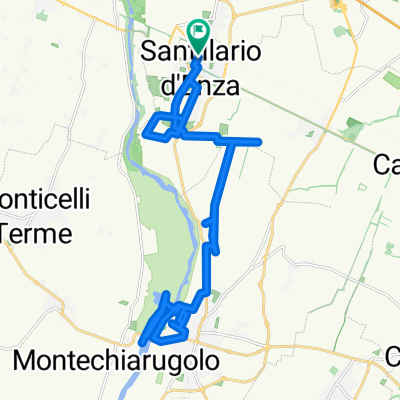
c) Anello Enza 1: Sant'Ilario -Montecchio -San Polo -Cerezzola
Eine Fahrradroute, die in Sant'Ilario d'Enza, Emilia-Romagna, Italien beginnt.
Übersicht
Über diese Route
Anello in gran parte non asfaltato, ma su piste pedalabili. Partiamo dalla stazione di Sant'Ilario La prima parte si svolge risalendo l pista del fiume Enza passando da Montecchio San Polo, quindi la greenway in fregio al canale Ducale fino alla derivazione idraulica dal fiume Enza, in località Cerezzola. Per il ritorno si lascia il canale Ducale per salire all'abitato di Ciano d'Enza scendendo fino al ponte ferroviario dove si lascia la provinciale per una pista a base delle colline matildiche per San Polo. Poi Montecchio su asfalto per prendere la direzione Calerno su ciclabile e per via dei Martiri fino al sottopasso per tornare a Sant'Ilario
English
Mostly unpaved ring, but on pedalable tracks. We start from the Sant'Ilario railway station. The first part takes place by going up the track of the river Enza passing through Montecchio and San Polo, then the greenway along the Ducal canal up to the hydraulic derivation from the river Enza, in the locality of Cerezzola. For the return, leave the Ducal canal to go up to the town of Ciano d'Enza, descending to the railway bridge where you leave the provincial road going right then left for a track at the base of the Matildic hills to San Polo. Then Montecchio on asphalt to take the Calerno direction on the cycle path and along via dei Martiri up to the underpass to return to Sant'Ilario
- -:--
- Dauer
- 56,6 km
- Distanz
- 235 m
- Aufstieg
- 236 m
- Abstieg
- ---
- Ø-Tempo
- 218 m
- Max. Höhe

Fotos von der Route
 Anello Enza 1: Sant'Ilario -Montecchio -San Polo -Cerezzola\"")
 Anello Enza 1: Sant'Ilario -Montecchio -San Polo -Cerezzola\"")
 Anello Enza 1: Sant'Ilario -Montecchio -San Polo -Cerezzola\"")
 Anello Enza 1: Sant'Ilario -Montecchio -San Polo -Cerezzola\"")
Routenqualität
Wegtypen und Untergründe entlang der Route
Wegtypen
Ruhige Straße
17,3 km
(31 %)
Forst- / Feldweg
11,5 km
(20 %)
Untergründe
Befestigt
19 km
(34 %)
Unbefestigt
20,7 km
(37 %)
Asphalt
18,9 km
(33 %)
Schotter
16,4 km
(29 %)
Highlights der Route
POIs entlang der Route
 Anello Enza 1: Sant'Ilario -Montecchio -San Polo -Cerezzola\" hervor")
Interessanter Ort nach 8,1 km
Possibile variante per accorciare il percorso A/R Sant'Ilario/Montecchio. Pa percorribilità su strada Casoni non è garantita per la presenza di sbarre, ma al momento le bici sono tollerate.
 Anello Enza 1: Sant'Ilario -Montecchio -San Polo -Cerezzola\" hervor")
Interessanter Ort nach 30,8 km
Ponticello rio VIco Rio Vico creek little bridge
 Anello Enza 1: Sant'Ilario -Montecchio -San Polo -Cerezzola\" hervor")
Interessanter Ort nach 31,7 km
Guado Rio Luceria Rio Luceria creek ford
 Anello Enza 1: Sant'Ilario -Montecchio -San Polo -Cerezzola\" hervor")
Interessanter Ort nach 52,5 km
Scorciatoia strada Casoni
Weiter mit Bikemap
Diese Radroute verwenden, bearbeiten oder herunterladen
Du möchtest c) Anello Enza 1: Sant'Ilario -Montecchio -San Polo -Cerezzola fahren oder sie für deine eigene Reise anpassen? Folgendes kannst du mit dieser Bikemap-Route machen:
Gratis Funktionen
- Speichere diese Route als Favorit oder in einer Sammlung
- Kopiere & plane deine eigene Version dieser Route
- Synchronisiere deine Route mit Garmin oder Wahoo
Premium-Funktionen
Kostenlose Testversion für 3 Tage oder einmalige Zahlung. Mehr über Bikemap Premium.
- Navigiere diese Route auf iOS & Android
- Exportiere eine GPX / KML-Datei dieser Route
- Erstelle deinen individuellen Ausdruck (Jetzt kostenlos ausprobieren)
- Lade diese Route für die Offline-Navigation herunter
Entdecke weitere Premium-Funktionen.
Bikemap Premium aktivierenVon unserer Community
Sant'Ilario d'Enza: Andere beliebte Routen, die hier beginnen
 SANT'ILARIO-VIGNALE-REGGIO EMILIA
- Distanz
- 52,3 km
- Aufstieg
- 234 m
- Abstieg
- 235 m
- Standort
- Sant'Ilario d'Enza, Emilia-Romagna, Italien
 sant'ilario - Bosco di corniglio
- Distanz
- 62,3 km
- Aufstieg
- 929 m
- Abstieg
- 83 m
- Standort
- Sant'Ilario d'Enza, Emilia-Romagna, Italien
 Monticelli terme tour Giorno 1 con fermo bagagli
- Distanz
- 47,2 km
- Aufstieg
- 341 m
- Abstieg
- 295 m
- Standort
- Sant'Ilario d'Enza, Emilia-Romagna, Italien
 Famiglie in bici, anello Sant'Ilario -Montecchio
- Distanz
- 21,3 km
- Aufstieg
- 48 m
- Abstieg
- 47 m
- Standort
- Sant'Ilario d'Enza, Emilia-Romagna, Italien
 c) Anello Enza 1: Sant'Ilario -Montecchio -San Polo -Cerezzola
- Distanz
- 56,6 km
- Aufstieg
- 235 m
- Abstieg
- 236 m
- Standort
- Sant'Ilario d'Enza, Emilia-Romagna, Italien
 Da Via Antonio Gramsci a Via Antonio Gramsci 30E
- Distanz
- 33,1 km
- Aufstieg
- 188 m
- Abstieg
- 217 m
- Standort
- Sant'Ilario d'Enza, Emilia-Romagna, Italien
 Famiglie in bici, anello dei Pantari Sant'Ilario Gattatico (Re)
- Distanz
- 16 km
- Aufstieg
- 28 m
- Abstieg
- 26 m
- Standort
- Sant'Ilario d'Enza, Emilia-Romagna, Italien
 Monticelli terme tour Giorno 1
- Distanz
- 39,5 km
- Aufstieg
- 280 m
- Abstieg
- 235 m
- Standort
- Sant'Ilario d'Enza, Emilia-Romagna, Italien
In der App öffnen