

a) 03 PC Ciclovia del Po piacentino (via Po)
Eine Fahrradroute, die in Castel San Giovanni, Emilia-Romagna, Italien beginnt.
Übersicht
Über diese Route
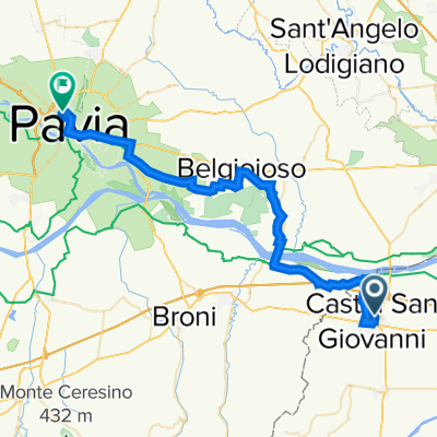
Route entsprechend dem piacenzanischen Teil der Ciclovia del Po auf der rechten Flussseite. Der Startpunkt wurde am Bahnhof Castel San Giovanni gesetzt, um den Trenitalia-Zug-Plus-Fahrrad-Service hervorzuheben. Die Strecke verläuft auf dem Gelände des Hauptdeichs des Po, ist aber tatsächlich für eine relativ effiziente Passage optimiert, indem einige Abkürzungen in der Nähe der tiefsten Mäander des Flusses eingeführt wurden. Insbesondere wurden im Westen von Piacenza einschließlich des Mündungsgebiets der Trebbia und teilweise im Gebiet Mortizza östlich von Piacenza einige Abschnitte verkürzt. Diese unterschiedlichen Interpretationen der Strecke können je nach den konsultierten Informationsquellen zu unterschiedlichen Kilometermengen führen. Die Provinz Piacenza, Inhaber der Verwaltung des Radwegs, gibt für die "via Po" eine Länge von 136 km an, entsprechend der Länge des Hauptdeichs.
- -:--
- Dauer
- 91,9 km
- Distanz
- 168 m
- Aufstieg
- 199 m
- Abstieg
- ---
- Ø-Tempo
- 74 m
- Max. Höhe

Fotos von der Route
 03 PC Ciclovia del Po piacentino (via Po)\"")
 03 PC Ciclovia del Po piacentino (via Po)\"")
 03 PC Ciclovia del Po piacentino (via Po)\"")
 03 PC Ciclovia del Po piacentino (via Po)\"")
Routenqualität
Wegtypen und Untergründe entlang der Route
Wegtypen
Ruhige Straße
43,2 km
(47 %)
Zufahrtsstraße
24,8 km
(27 %)
Untergründe
Befestigt
44,1 km
(48 %)
Unbefestigt
13,8 km
(15 %)
Asphalt
42,3 km
(46 %)
Natürlicher Untergrund
5,5 km
(6 %)
Weiter mit Bikemap
Diese Radroute verwenden, bearbeiten oder herunterladen
Du möchtest a) 03 PC Ciclovia del Po piacentino (via Po) fahren oder sie für deine eigene Reise anpassen? Folgendes kannst du mit dieser Bikemap-Route machen:
Gratis Funktionen
- Speichere diese Route als Favorit oder in einer Sammlung
- Kopiere & plane deine eigene Version dieser Route
- Teile sie in Etappen ein, um eine mehrtägige Tour zu erstellen
- Synchronisiere deine Route mit Garmin oder Wahoo
Premium-Funktionen
Kostenlose Testversion für 3 Tage oder einmalige Zahlung. Mehr über Bikemap Premium.
- Navigiere diese Route auf iOS & Android
- Exportiere eine GPX / KML-Datei dieser Route
- Erstelle deinen individuellen Ausdruck (Jetzt kostenlos ausprobieren)
- Lade diese Route für die Offline-Navigation herunter
Entdecke weitere Premium-Funktionen.
Bikemap Premium aktivierenVon unserer Community
Castel San Giovanni: Andere beliebte Routen, die hier beginnen
 a) 03 PC Ciclovia del Po piacentino (via Po)
- Distanz
- 91,9 km
- Aufstieg
- 168 m
- Abstieg
- 199 m
- Standort
- Castel San Giovanni, Emilia-Romagna, Italien
 Castel San Giovanni - Ziano - Pianello
- Distanz
- 60,9 km
- Aufstieg
- 1.032 m
- Abstieg
- 1.038 m
- Standort
- Castel San Giovanni, Emilia-Romagna, Italien
 I - Gardasee-Mailand-5 - Piacenza-Pavia - 40 km
- Distanz
- 40,1 km
- Aufstieg
- 121 m
- Abstieg
- 108 m
- Standort
- Castel San Giovanni, Emilia-Romagna, Italien
 EuroVelo 5 - 11 - Castel San Giovanni to Berceto
- Distanz
- 159,1 km
- Aufstieg
- 1.176 m
- Abstieg
- 414 m
- Standort
- Castel San Giovanni, Emilia-Romagna, Italien
 River Po cycle route (Emilia Romagna region west) Ciclovia del Po Emilia Ovest
- Distanz
- 160,1 km
- Aufstieg
- 47 m
- Abstieg
- 90 m
- Standort
- Castel San Giovanni, Emilia-Romagna, Italien
 Famiglie in bici, Ciclovia dei Fontanili Castel S.Giovanni Sarmato (Pc)
- Distanz
- 18,8 km
- Aufstieg
- 104 m
- Abstieg
- 106 m
- Standort
- Castel San Giovanni, Emilia-Romagna, Italien
 Grande traversa di pianura in Emilia Romagna
- Distanz
- 351,9 km
- Aufstieg
- 303 m
- Abstieg
- 365 m
- Standort
- Castel San Giovanni, Emilia-Romagna, Italien
 Colli piacentini 1
- Distanz
- 55,8 km
- Aufstieg
- 603 m
- Abstieg
- 603 m
- Standort
- Castel San Giovanni, Emilia-Romagna, Italien
In der App öffnen