
Synoikismós Chavaríou en bici
Descubre un mapa con 3 rutas y senderos en bici cerca de Synoikismós Chavaríou, creados por nuestra comunidad.
Sé un pionero
Inspira a otros ciclistas con tu ruta en Synoikismós Chavaríou
Bikemap es una comunidad ciclista global con millones de rutas creadas por ciclistas como tú. Todavía hay pocas rutas en Synoikismós Chavaríou, así que traza tus recorridos favoritos en el mapa para ayudar a otros a descubrir los mejores caminos para pedalear.
De nuestra comunidad
Las mejores rutas en bici en y alrededor de Synoikismós Chavaríou

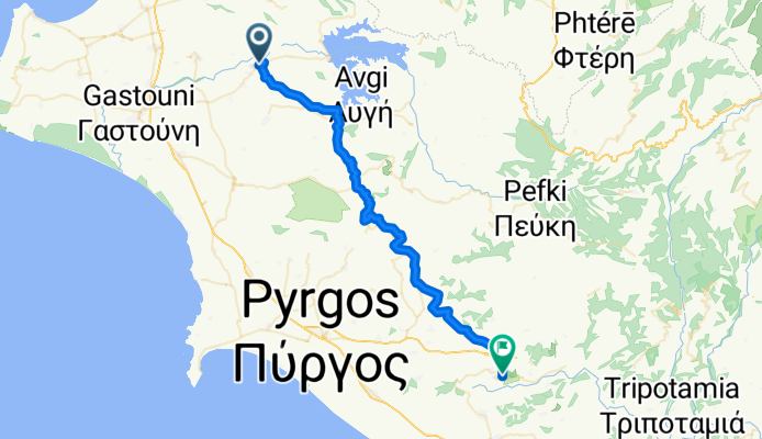
Limni Pineas - Patra Track Nr. 6
Ruta ciclista en Synoikismós Chavaríou, Western Greece, Grecia
- 52,6 km
- Distancia
- 778 m
- Ascenso
- 851 m
- Descenso

Cycling Tour Pinios Lake & Elis Archeological Site
Ruta ciclista en Synoikismós Chavaríou, Western Greece, Grecia
- 21,9 km
- Distancia
- 88 m
- Ascenso
- 219 m
- Descenso


Το Μονοπάτι της Εκεχειρίας - The Route of Truce
Ruta ciclista en Synoikismós Chavaríou, Western Greece, Grecia
Οικοτουριστική Διαδρομή Ήλιδας - Ολυμπίας "Το Μονοπάτι της Εκεχειρίας" /
Eco-Touristic Route Ilis - Olympia "The Route of Truce"
Starting from Ancient Ilis, the “Route of Truce” crosses 13 semi-hilly villages of the Ilia Prefecture and Municipalities, Ilis (Dafni, Keramidia, Dafniotissa, Peristeri), Pyrgos (Chimadio, Sopi, Karatoulas, Magoula, Latzoi), Ancient Olympia (Iraklia, Pournari, Pelopio, Platanos), and ends in Ancient Olympia.
Through the “Route of Truce”, the visitors run along a route full of olive trees, vines, pomegranates, and herbs. Along the way, visitors will also be able to visit the towns of Ιlis and Olympia and learn more about the culture and the history of the area.
Through this project, we wish to raise awareness of the “Route of Truce,” inland Greece, and abroad in order to encourage tourism within the Elis hinterland.
- 49,8 km
- Distancia
- 588 m
- Ascenso
- 579 m
- Descenso