
Rochester en bici
Descubre un mapa con 46 rutas y senderos en bici cerca de Rochester, creados por nuestra comunidad.
Retrato de la región
Conoce Rochester
Encuentra la ruta en bicicleta ideal para ti en Rochester, donde tenemos 46 rutas ciclistas para explorar.
2360 km
Distancia registrada
46
Rutas ciclistas
Comunidad
Usuarios más activos en Rochester


De nuestra comunidad
Las mejores rutas en bici en y alrededor de Rochester

Periple 11 / 28
Ruta ciclista en Rochester, Inglaterra, Reino Unido
- 167,7 km
- Distancia
- 1250 m
- Ascenso
- 1182 m
- Descenso

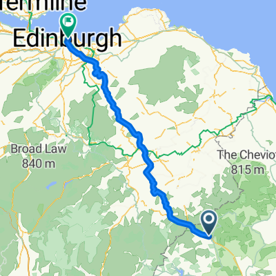
BfCiC recce
Ruta ciclista en Rochester, Inglaterra, Reino Unido
- 214,8 km
- Distancia
- 940 m
- Ascenso
- 1119 m
- Descenso

Kielder észak
Ruta ciclista en Rochester, Inglaterra, Reino Unido
- 17,1 km
- Distancia
- 178 m
- Ascenso
- 185 m
- Descenso

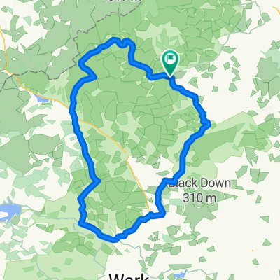
Kielder Water
Ruta ciclista en Rochester, Inglaterra, Reino Unido
- 48,4 km
- Distancia
- 444 m
- Ascenso
- 444 m
- Descenso
Descubre más rutas
 8 Otterburn Green, Newcastle Upon Tyne to Foundry Farm, Hexham
- Distancia
- 30,6 km
- Ascenso
- 363 m
- Descenso
- 465 m
- Ubicación
- Rochester, Inglaterra, Reino Unido

Edge810®
Rochester Radfahren- Distancia
- 39,8 km
- Ascenso
- 514 m
- Descenso
- 512 m
- Ubicación
- Rochester, Inglaterra, Reino Unido
 LEJOG - Day 10
- Distancia
- 112,6 km
- Ascenso
- 921 m
- Descenso
- 1112 m
- Ubicación
- Rochester, Inglaterra, Reino Unido

Edge810®
Rochester Cycling- Distancia
- 9,7 km
- Ascenso
- 161 m
- Descenso
- 155 m
- Ubicación
- Rochester, Inglaterra, Reino Unido

Edge810®
Rochester Cycling- Distancia
- 40,1 km
- Ascenso
- 519 m
- Descenso
- 522 m
- Ubicación
- Rochester, Inglaterra, Reino Unido
 Lew and Cal round Kielder
- Distancia
- 41,6 km
- Ascenso
- 253 m
- Descenso
- 253 m
- Ubicación
- Rochester, Inglaterra, Reino Unido
 Pt9 THE FINAL DAY
- Distancia
- 93,5 km
- Ascenso
- 509 m
- Descenso
- 675 m
- Ubicación
- Rochester, Inglaterra, Reino Unido
 wild camping weekend
- Distancia
- 89,9 km
- Ascenso
- 872 m
- Descenso
- 872 m
- Ubicación
- Rochester, Inglaterra, Reino Unido