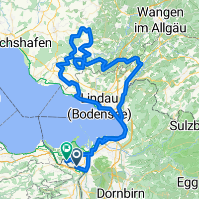
Sankt Margrethen en bici
Descubre un mapa con 251 rutas y senderos en bici cerca de Sankt Margrethen, creados por nuestra comunidad.
Retrato de la región
Conoce Sankt Margrethen
Encuentra la ruta en bicicleta ideal para ti en Sankt Margrethen, donde tenemos 251 rutas ciclistas para explorar. La mayoría de la gente sale en bicicleta por aquí en los meses de mayo y julio.
28.407 km
Distancia registrada
251
Rutas ciclistas
5395
Población
Comunidad
Usuarios más activos en Sankt Margrethen
Rutas seleccionadas a mano
Descubre Sankt Margrethen a través de estas colecciones

Recorrido
De nuestra comunidad
Las mejores rutas en bici en y alrededor de Sankt Margrethen
SchweizMobil 4: Alpenpanorama-Route
Ruta ciclista en Sankt Margrethen, Canton of St. Gallen, Switzerland
Die Alpenpanorama-Route traversiert pass- und schluchtenreich das nördliche Alpenvorland. Die konditionell anspruchsvolle Fahrt wird mit grandiosen Ausblicken belohnt.
- 480 km
- Distancia
- 8734 m
- Ascenso
- 8732 m
- Descenso
BS Tag 1 Höchst - Romanshorn - Konstanz
Ruta ciclista en Sankt Margrethen, Canton of St. Gallen, Switzerland
- 68,2 km
- Distancia
- 18 m
- Ascenso
- 18 m
- Descenso
BRUTAL 2013 Rainer Waigel Variante A-CH
Ruta ciclista en Sankt Margrethen, Canton of St. Gallen, Switzerland
<span style="font-family: Arial; color: navy; font-size: x-small;"><span style="font-size: 10pt;">Sa. St . Margarethen -> Hochtannberg -> Bach</span></span>
<span style="font-family: Arial; color: navy; font-size: x-small;"><span style="font-size: 10pt;">So. Bach -> Hochtennjoch -> Mittenwald -> Tegernsee</span></span>
<span style="font-family: Arial; color: navy; font-size: x-small;"><span style="font-size: 10pt;">Mo. Tegernsee-> Schliersee -> Kufstein -> Kitzbühl</span></span>
<span style="font-family: Arial; color: navy; font-size: x-small;"><span style="font-size: 10pt;">Die. Kitzbühl-> Lienz</span></span>
<span style="font-family: Arial; color: navy; font-size: x-small;"><span style="font-size: 10pt;">Mi. Lienz -> Calazo di Cadore</span></span>
<span style="font-family: Arial; color: navy; font-size: x-small;"><span style="font-size: 10pt;">Do Calazo di Cadore –> Bozen</span></span>
<span style="font-family: Arial; color: navy; font-size: x-small;"><span style="font-size: 10pt;">Fr. Bozen -> Zernez</span></span>
<span style="font-family: Arial; color: navy; font-size: x-small;"><span style="font-size: 10pt;">Sa. Zernez -> St Margarehen oder ZH</span></span>
- 1016,5 km
- Distancia
- 8675 m
- Ascenso
- 8658 m
- Descenso
St.Anton
Ruta ciclista en Sankt Margrethen, Canton of St. Gallen, Switzerland
05.09.17 16:43
- 38,3 km
- Distancia
- 852 m
- Ascenso
- 849 m
- Descenso
Descubre más rutas
- 2013 St. Margerethen-Zagreb
- Distancia
- 876,8 km
- Ascenso
- 7042 m
- Descenso
- 7085 m
- Ubicación
- Sankt Margrethen, Canton of St. Gallen, Switzerland
- Höchst-Konstanz (3)
- Distancia
- 53,1 km
- Ascenso
- 57 m
- Descenso
- 56 m
- Ubicación
- Sankt Margrethen, Canton of St. Gallen, Switzerland
- Bodensee harmadik nap megtett út
- Distancia
- 60,3 km
- Ascenso
- 40 m
- Descenso
- 42 m
- Ubicación
- Sankt Margrethen, Canton of St. Gallen, Switzerland
- Bodensee-Comer See
- Distancia
- 315,6 km
- Ascenso
- 2560 m
- Descenso
- 2523 m
- Ubicación
- Sankt Margrethen, Canton of St. Gallen, Switzerland
- Alpenpanorama- Route Nr. 4
- Distancia
- 478,9 km
- Ascenso
- 12.216 m
- Descenso
- 12.212 m
- Ubicación
- Sankt Margrethen, Canton of St. Gallen, Switzerland
- 20160804_173222.gpx
- Distancia
- 38,1 km
- Ascenso
- 14 m
- Descenso
- 16 m
- Ubicación
- Sankt Margrethen, Canton of St. Gallen, Switzerland
- Höchst - Walzenhausen - Heiden - Retour
- Distancia
- 26 km
- Ascenso
- 759 m
- Descenso
- 759 m
- Ubicación
- Sankt Margrethen, Canton of St. Gallen, Switzerland
- 4-Tages-Passfahrt Vorarlberg-Italien-Graubünden
- Distancia
- 330,4 km
- Ascenso
- 4568 m
- Descenso
- 4447 m
- Ubicación
- Sankt Margrethen, Canton of St. Gallen, Switzerland