
Tignes en bici
Descubre un mapa con 91 rutas y senderos en bici cerca de Tignes, creados por nuestra comunidad.
Retrato de la región
Conoce Tignes
Encuentra la ruta en bicicleta ideal para ti en Tignes, donde tenemos 91 rutas ciclistas para explorar. La mayoría de la gente sale en bicicleta por aquí en el mes de julio.
7484 km
Distancia registrada
91
Rutas ciclistas
2385
Población


De nuestra comunidad
Las mejores rutas en bici en y alrededor de Tignes
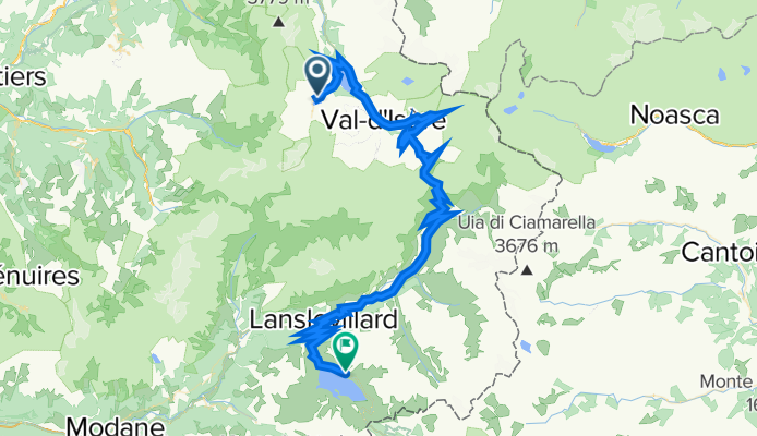
Col de l'Iseran and Mont Cenis
Ruta ciclista en Tignes, Auvernia-Ródano-Alpes, Francia
- 72 km
- Distancia
- 1711 m
- Ascenso
- 1739 m
- Descenso

Guillestre - Tignes
Ruta ciclista en Tignes, Auvernia-Ródano-Alpes, Francia
- 231,2 km
- Distancia
- 4232 m
- Ascenso
- 5325 m
- Descenso

3.Route des Grandes Alpes - Day Three
Ruta ciclista en Tignes, Auvernia-Ródano-Alpes, Francia
<span style="margin: 0px; padding: 0px; border: 0px; outline: 0px; font-size: medium; vertical-align: baseline; background-color: transparent; color: rgb(0, 0, 0); font-family: Tahoma, Geneva, Kalimati, sans-serif; background-position: initial initial; background-repeat: initial initial;">105km 1950m gain, 2 cat. 1 cols</span>
<span style="margin: 0px; padding: 0px; border: 0px; outline: 0px; font-size: small; vertical-align: baseline; background-color: transparent; color: rgb(0, 0, 0); font-family: Tahoma, Geneva, Kalimati, sans-serif; background-position: initial initial; background-repeat: initial initial;">From Val d’Isere it is straight up to the Iseran, an exposed and tough start to the morning but well worth it for the view from the top. The descent seems endless at 73km but well deserved and very beautiful, it brings us down to St Michel-de-Maurienne where with rested legs we tackle the Col du Telegraphe which at 830m height gain is a tough but good end to the day as it winds up through the trees which offer good shade on a hot day. A short descent takes us to Valloire and the hotel.</span>
<span style="margin: 0px; padding: 0px; border: 0px; outline: 0px; font-size: small; vertical-align: baseline; background-color: transparent; color: rgb(0, 0, 0); font-family: Tahoma, Geneva, Kalimati, sans-serif; background-position: initial initial; background-repeat: initial initial;">Accommodation: </span><span style="color: rgb(34, 34, 34); font-family: Arial, Verdana, sans-serif;">Hôtel Patchwork, </span><span style="color: rgb(34, 34, 34); font-family: Arial, Verdana, sans-serif;">Route des Grandes Alpes, </span><span style="color: rgb(34, 34, 34); font-family: Arial, Verdana, sans-serif;">73450 Valloire, </span><span style="color: rgb(34, 34, 34); font-family: Arial, Verdana, sans-serif;">04.79.59.00.99</span>
- 109,8 km
- Distancia
- 1851 m
- Ascenso
- 2250 m
- Descenso

to furnicular
Ruta ciclista en Tignes, Auvernia-Ródano-Alpes, Francia
- 0,6 km
- Distancia
- 12 m
- Ascenso
- 32 m
- Descenso
Descubre más rutas
 Tignes Cormet De Roselend Val Thorens 151km
- Distancia
- 151,4 km
- Ascenso
- 3147 m
- Descenso
- 2928 m
- Ubicación
- Tignes, Auvernia-Ródano-Alpes, Francia
 TDLA etp 5B Tignes - colle di somelier
- Distancia
- 148,9 km
- Ascenso
- 3989 m
- Descenso
- 3109 m
- Ubicación
- Tignes, Auvernia-Ródano-Alpes, Francia
 Tignes-Val Thorens-Cormet d´Acheres-Col du Pre-Cormet de Roseland-Tignes
- Distancia
- 231,2 km
- Ascenso
- 5026 m
- Descenso
- 5059 m
- Ubicación
- Tignes, Auvernia-Ródano-Alpes, Francia
 Tour de France 2019 3. Etappe
- Distancia
- 216,3 km
- Ascenso
- 1040 m
- Descenso
- 2435 m
- Ubicación
- Tignes, Auvernia-Ródano-Alpes, Francia
 TIGNES - COL DE L'ISERAN
- Distancia
- 28,6 km
- Ascenso
- 1267 m
- Descenso
- 595 m
- Ubicación
- Tignes, Auvernia-Ródano-Alpes, Francia
 Tignes - Col D´Iseran
- Distancia
- 30,6 km
- Ascenso
- 1209 m
- Descenso
- 583 m
- Ubicación
- Tignes, Auvernia-Ródano-Alpes, Francia
 Tignes - Col de Petit st. Bernard
- Distancia
- 39,8 km
- Ascenso
- 1121 m
- Descenso
- 1057 m
- Ubicación
- Tignes, Auvernia-Ródano-Alpes, Francia
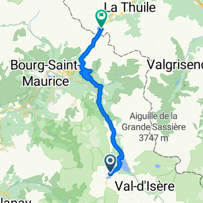
 Tignes to D902, Val-d'Isère
- Distancia
- 29,4 km
- Ascenso
- 1007 m
- Descenso
- 330 m
- Ubicación
- Tignes, Auvernia-Ródano-Alpes, Francia