Montélimar en bici
Descubre un mapa con 325 rutas y senderos en bici cerca de Montélimar, creados por nuestra comunidad.
Retrato de la región
Conoce Montélimar
Encuentra la ruta en bicicleta ideal para ti en Montélimar, donde tenemos 325 rutas ciclistas para explorar. La mayoría de la gente sale en bicicleta por aquí en los meses de julio y agosto.
36.865 km
Distancia registrada
325
Rutas ciclistas
35.637
Población
Comunidad
Usuarios más activos en Montélimar
Rutas seleccionadas a mano
Descubre Montélimar a través de estas colecciones
Recorrido
De nuestra comunidad
Las mejores rutas en bici en y alrededor de Montélimar
Montélimar to Fournès
Ruta ciclista en Montélimar, Auvernia-Ródano-Alpes, Francia
- 87,4 km
- Distancia
- 654 m
- Ascenso
- 674 m
- Descenso
2016 Ride Day 97 - Montélimar Circle to East
Ruta ciclista en Montélimar, Auvernia-Ródano-Alpes, Francia
- 64,8 km
- Distancia
- 548 m
- Ascenso
- 548 m
- Descenso
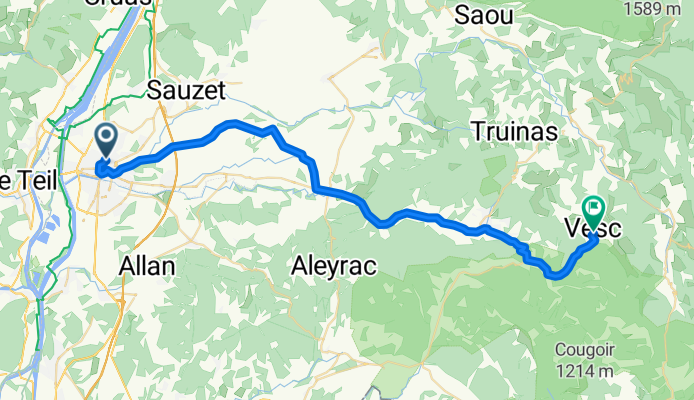
2016 Ride Day 98 - Montélimar to Vesc
Ruta ciclista en Montélimar, Auvernia-Ródano-Alpes, Francia
- 42,6 km
- Distancia
- 613 m
- Ascenso
- 101 m
- Descenso
Aleyrac
Ruta ciclista en Montélimar, Auvernia-Ródano-Alpes, Francia
- 63,2 km
- Distancia
- 791 m
- Ascenso
- 791 m
- Descenso
Descubre más rutas
 13. Tag Saint Julien du Gua - Saint Nazaire en Royans
- Distancia
- 103,8 km
- Ascenso
- 219 m
- Descenso
- 132 m
- Ubicación
- Montélimar, Auvernia-Ródano-Alpes, Francia
 pour aller chez Hervé
- Distancia
- 62,3 km
- Ascenso
- 520 m
- Descenso
- 475 m
- Ubicación
- Montélimar, Auvernia-Ródano-Alpes, Francia
 08 Montelimar - Avignon
- Distancia
- 87,5 km
- Ascenso
- 25 m
- Descenso
- 92 m
- Ubicación
- Montélimar, Auvernia-Ródano-Alpes, Francia
 6- Montélimar - Roquemaure
- Distancia
- 76,6 km
- Ascenso
- 12 m
- Descenso
- 64 m
- Ubicación
- Montélimar, Auvernia-Ródano-Alpes, Francia
 C'est beau le Niger (provençal) à vélo 2016
- Distancia
- 365,8 km
- Ascenso
- 2835 m
- Descenso
- 2886 m
- Ubicación
- Montélimar, Auvernia-Ródano-Alpes, Francia
 Montelimar - Mont Ventoux
- Distancia
- 153,9 km
- Ascenso
- 1895 m
- Descenso
- 83 m
- Ubicación
- Montélimar, Auvernia-Ródano-Alpes, Francia
 Etape 4 : Montelimar ==> Pont ST Esprit
- Distancia
- 47,9 km
- Ascenso
- 50 m
- Descenso
- 76 m
- Ubicación
- Montélimar, Auvernia-Ródano-Alpes, Francia
 Montelimar (col Ardeche)
- Distancia
- 55,7 km
- Ascenso
- 840 m
- Descenso
- 845 m
- Ubicación
- Montélimar, Auvernia-Ródano-Alpes, Francia


