
Laguiole en bici
Descubre un mapa con 92 rutas y senderos en bici cerca de Laguiole, creados por nuestra comunidad.
Retrato de la región
Conoce Laguiole
Encuentra la ruta en bicicleta ideal para ti en Laguiole, donde tenemos 92 rutas ciclistas para explorar. La mayoría de la gente sale en bicicleta por aquí en los meses de julio y agosto.
6556 km
Distancia registrada
92
Rutas ciclistas
1317
Población
Comunidad
Usuarios más activos en Laguiole

De nuestra comunidad
Las mejores rutas en bici en y alrededor de Laguiole


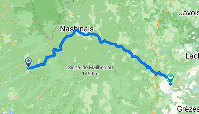
7.etapa St Chely d Aubrac - Le Malzieu-Ville
Ruta ciclista en Laguiole, Occitanie, Francia
Trasa je určena pro všechny typy kol.
Pro silniční kolo je však nutné v Montgrousset pokračovat po silnici D900 k odbočce na Marchastel (vynechat cestu přes travnaté pláně). Dále za vesnicí Rieutort d Aubrac pokrčovat na silnici D987 na Malbouzon, kde se silnice napojí na cestu D73 (vynechat "Poutní cestu").
kemp Le
Malzieu-Ville
Hezký kemp / teplá voda bez problému / příjemné sociální
zařízení / zásuvka se zemnícím kolíkem je pouze v kuchyňce (pro použití
rchlovarné konvice) / v umývárně jsou pouze zásuvky s dvěmi dírky a sice na
zářivkách nad umyvadlem (na mobily, holící strojky atd.) / Možnost spát i v
chatičkách, ale podrobnosti o tomto typu ubytování nemám. Není příjem mobilního
signálu.
Údaje z cyklocomputeru:trasa 86,29 km / nastoupáno 1432 metrů / 5:01:37 hod
- 80,6 km
- Distancia
- 934 m
- Ascenso
- 877 m
- Descenso

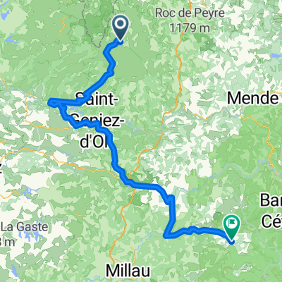
Ride Day 32—13 Oct 2005—48260 Recoules D'Aubrac (Nasbinals) to 15300 Murat
Ruta ciclista en Laguiole, Occitanie, Francia
<span style="font-size: 12pt; font-family: Arial;">Into every life, a little
rain must fall.<span> </span>Shortly after
starting out in the chilly morning, we donned our rain pants and booties due to
a light rain.<span> </span>While it never got
seriously heavy, it was more than light and continued steadily for several
hours.<span> </span>The most difficult part of
this was the descent from about 1050 M along D13 and D989 into Chaudes-Aigues
at about 750 M.<span> </span>Happily, while we
were climbing back to the 1000+ M level north of Chaudes-Aigues, the rain
lightened…and we even could see our shadows by the time we were on D16.<span> </span>We hadn’t expected such a nice end to
the day.</span>
<span style="font-size: 12pt; font-family: Arial;">As a final point, we left the Lozère Department and entered the Cantal
Department</span><span style="font-size: 12pt; font-family: Arial;"> just before entering St
Urcize</span><span style="font-size: 12pt; font-family: Arial;">.<span> </span>This also meant that
we passed from the Languedoc-Roussillon Region to the Auvergne Region</span>
<span style="font-size: 12pt; font-family: Arial;">Great low traffic roads.</span>
Background:<br /><br /><br />My wife and I have been doing self-supported tours in Western Europe (a majority in France) since 1993. This series of rides covers our 2005 2 month route through parts of France. Our beginning and ending point is near Chaduri (south of Angoulême) where our friends have a farm with Gites and Chambres d'Hotes.<br /><br /><br />We rode our Dawes touring bicycles purchased in 1993 heavily loaded with 700Cx32 tires. All of our riding was on paved roads, mostly with very little traffic.<br /><br /><br />If any questions, feel free to email me at jeffkadet@netdiving.com<br /><br /><br />Jeff
- 67,6 km
- Distancia
- 587 m
- Ascenso
- 757 m
- Descenso
2014 Ride Day 99 - St-Chély-d'Aubrac to Marvejols
Ruta ciclista en Laguiole, Occitanie, Francia
Excellent low traffic roads and scenery until getting into Marvejols.
- 44,7 km
- Distancia
- 673 m
- Ascenso
- 856 m
- Descenso
Descubre más rutas
 09-MassifCentral
- Distancia
- 60,8 km
- Ascenso
- 509 m
- Descenso
- 1057 m
- Ubicación
- Laguiole, Occitanie, Francia
 Nasbidaniel2
- Distancia
- 60,7 km
- Ascenso
- 627 m
- Descenso
- 627 m
- Ubicación
- Laguiole, Occitanie, Francia
 étape 5
- Distancia
- 105 km
- Ascenso
- 1228 m
- Descenso
- 1265 m
- Ubicación
- Laguiole, Occitanie, Francia
 TAP J 1
- Distancia
- 78,4 km
- Ascenso
- 900 m
- Descenso
- 1474 m
- Ubicación
- Laguiole, Occitanie, Francia
 JATIENZA2
- Distancia
- 44,1 km
- Ascenso
- 860 m
- Descenso
- 858 m
- Ubicación
- Laguiole, Occitanie, Francia
 Laguiole - Viaduc de Garabit Etape 3
- Distancia
- 67,3 km
- Ascenso
- 1282 m
- Descenso
- 1505 m
- Ubicación
- Laguiole, Occitanie, Francia
 Route de Sainte-Urcize 21, Nasbinals nach Avenue Albert Thomas 23, Capdenac-Gare
- Distancia
- 114 km
- Ascenso
- 2345 m
- Descenso
- 3338 m
- Ubicación
- Laguiole, Occitanie, Francia
 Aveyron-Tag1--4-0719 Runde angepasst 2
- Distancia
- 138,5 km
- Ascenso
- 1438 m
- Descenso
- 1922 m
- Ubicación
- Laguiole, Occitanie, Francia