Chanac en bici
Descubre un mapa con 245 rutas y senderos en bici cerca de Chanac, creados por nuestra comunidad.
Retrato de la región
Conoce Chanac
Encuentra la ruta en bicicleta ideal para ti en Chanac, donde tenemos 245 rutas ciclistas para explorar. La mayoría de la gente sale en bicicleta por aquí en los meses de julio y agosto.
8828 km
Distancia registrada
245
Rutas ciclistas
1212
Población
Comunidad
Usuarios más activos en Chanac
De nuestra comunidad
Las mejores rutas en bici en y alrededor de Chanac
Ride Day 30—11 Oct 2005—48210 St-Chely du Tarn/Sainte Énimie — Circle
Ruta ciclista en Chanac, Languedoc-Roussillon-Midi-Pyrénées, France
<span style="font-size: 12pt; font-family: Arial;">My wife had planned out a
great 100+ kilometer ride.<span> </span>However, with the relatively dark overcast sky, the occasional raindrop,
and the strong chilly wind that kept us bundled up, even on the two long climbs
of our ride, she scaled it back considerably.<span> </span>As one would expect, the sun actually made a showing just as
we arrived back at St Chély-du-Tarn at the end of the ride.<span> </span>So what else is new?<span> </span>The important things, though, are that
we didn’t get dumped on and we had a great ride.</span>
<span style="font-size: 12pt; font-family: Arial;">From Ste Énimie, we climbed up
to the plateau from the Tarn and headed northwest across the plateau to get to
Chanac.<span> </span>On the way up to the
plateau, we had spectacular views overlooking Ste Énimie.</span>
<span style="font-size: 12pt; font-family: Arial;">We found Chanac to be
a particularly pretty town that would be a great place to stay.<span> </span>It also had one of the nicest small
modest churches that I’ve seen.<span> </span>I
should add that Chanac is on the Lot River.<span> </span>We descended several hundred meters from the plateau to get
to it…which of course meant that we had to climb back up to the plateau to
return to the Gorges du Tarn and our hotel.</span>
<span style="font-size: 12pt; font-family: Arial;">On D998, just before the long
descent into Ste Énimie, there was a nice small hotel at a panoramic point that
was just incredible.<span> </span>The view
stretched for miles up and down the gorge showing many turnings of the river
and the rock walls.</span>
<span style="font-size: 12pt; font-family: Arial;">From the painting on the roadway, the Tour de France had
recently gone along D32 to Chanac.<span> </span>At one point, we saw contradicting painted remarks about Armstrong.<span> </span>One said roughly that he uses drugs and
that the Tour officials overlook it because of the money.<span> </span>The other supported Armstrong and
referred to his ten years of diligent work training for the Tour.</span>
Background:<br /><br /><br />My wife and I have been doing self-supported tours in Western Europe (a majority in France) since 1993. This series of rides covers our 2005 2 month route through parts of France. Our beginning and ending point is near Chaduri (south of Angoulême) where our friends have a farm with Gites and Chambres d'Hotes.<br /><br /><br />We rode our Dawes touring bicycles purchased in 1993 heavily loaded with 700Cx32 tires. All of our riding was on paved roads, mostly with very little traffic.<br /><br /><br />If any questions, feel free to email me at jeffkadet@netdiving.com<br /><br /><br />Jeff
- 58 km
- Distancia
- 951 m
- Ascenso
- 951 m
- Descenso
Ride Day 31—12 Oct 2005—48210 St-Chely du Tarn/Sainte Énimie to 48260 Recoules D'Aubrac (Nasbinals)
Ruta ciclista en Chanac, Languedoc-Roussillon-Midi-Pyrénées, France
This was another ride under
threatening skys all day…and we were again lucky not to get dumped on. The only discomforts were the cold wind
and the fog at the higher elevations when we got into the Aubrac mountains near
the end of the ride. While there,
we were generally between 1200 M and 1250 M, with the maximum being 1280
M. Our warmer riding gear worked
wonderfully. The countryside
there, though, was great for cycling; such a pleasure to be in.
Along N9, we saw construction of a new bridge that
reminded us of the viaduct we’d ridden under last year in 2004 just west of
Millau. Part of this new bridge was
hanging out with seemingly no support. A sign noted that the construction period was from 2003 to 2007. [In 2009, and perhaps other years as
well, we again rode along here finding the bridge completed.]
Riding through
Marvejols, we came across a sculpture of the Marvejols monster. Definitely a good place for a picture.
Background:My wife and I have been doing self-supported tours in Western Europe (a majority in France) since 1993. This series of rides covers our 2005 2 month route through parts of France. Our beginning and ending point is near Chaduri (south of Angoulême) where our friends have a farm with Gites and Chambres d'Hotes.We rode our Dawes touring bicycles purchased in 1993 heavily loaded with 700Cx32 tires. All of our riding was on paved roads, mostly with very little traffic.If any questions, feel free to email me at jeffkadet@netdiving.comJeff
- 86,1 km
- Distancia
- 1224 m
- Ascenso
- 644 m
- Descenso
F122-2024-Chanac-Florac-Les Vignes-La Malene-Chanac
Ruta ciclista en Chanac, Languedoc-Roussillon-Midi-Pyrénées, France
Traumhaftes Plateau von Florac nach Les Vignes mit Geierschwarm
- 118,7 km
- Distancia
- 3462 m
- Ascenso
- 3474 m
- Descenso
Tarnroute (Nr. 160) Ste. Enemie- Millau
Ruta ciclista en Chanac, Languedoc-Roussillon-Midi-Pyrénées, France
Über D907 und D187 am Tarn entlang
- 55,4 km
- Distancia
- 318 m
- Ascenso
- 436 m
- Descenso
Descubre más rutas
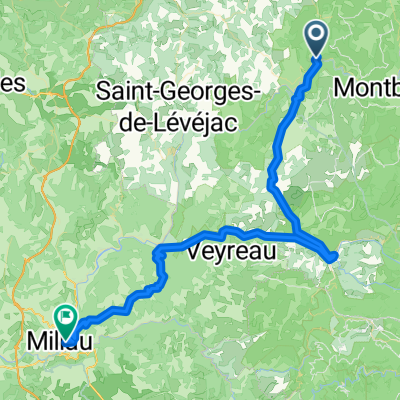
- Ste. Enimie - Millau (Causse Route nr. 159)
- Distancia
- 76,7 km
- Ascenso
- 1119 m
- Descenso
- 1262 m
- Ubicación
- Chanac, Languedoc-Roussillon-Midi-Pyrénées, France
- Entre Culture et le Monastier
- Distancia
- 36,7 km
- Ascenso
- 580 m
- Descenso
- 583 m
- Ubicación
- Chanac, Languedoc-Roussillon-Midi-Pyrénées, France
- 1999 Radlour am Tarn
- Distancia
- 90,3 km
- Ascenso
- 1143 m
- Descenso
- 1115 m
- Ubicación
- Chanac, Languedoc-Roussillon-Midi-Pyrénées, France
- F125-2024-Chanac-La Tieule-Chanac
- Distancia
- 65,1 km
- Ascenso
- 1794 m
- Descenso
- 1798 m
- Ubicación
- Chanac, Languedoc-Roussillon-Midi-Pyrénées, France
- F121-2024-Chanac-Quezac-Saint Emine-Chanac
- Distancia
- 63,4 km
- Ascenso
- 2103 m
- Descenso
- 2109 m
- Ubicación
- Chanac, Languedoc-Roussillon-Midi-Pyrénées, France
- F120-2024-Chanac-Saint Emine-La Malene-Chanac
- Distancia
- 61,1 km
- Ascenso
- 2248 m
- Descenso
- 2255 m
- Ubicación
- Chanac, Languedoc-Roussillon-Midi-Pyrénées, France
- F124-2024-Chanac-Einrollen-Trekking
- Distancia
- 58,7 km
- Ascenso
- 1670 m
- Descenso
- 1670 m
- Ubicación
- Chanac, Languedoc-Roussillon-Midi-Pyrénées, France
- F123-2024-Chanac-Correjac-Le Balmes-Chanac
- Distancia
- 42,9 km
- Ascenso
- 1243 m
- Descenso
- 1244 m
- Ubicación
- Chanac, Languedoc-Roussillon-Midi-Pyrénées, France