


- 13,3 km
- 123 m
- 93 m

Roma en bici
Descubre un mapa con 12.176 rutas y senderos en bici cerca de Roma, creados por nuestra comunidad.
Retrato de la región
Conoce Roma
Encuentra la ruta en bicicleta ideal para ti en Roma, donde tenemos 12 176 rutas ciclistas para explorar. La mayoría de la gente sale en bicicleta por aquí en los meses de mayo y junio.
724.783 km
Distancia registrada
12.176
Rutas ciclistas
2,3 millones
Población
Comunidad
Usuarios más activos en Roma
Rutas seleccionadas a mano
Descubre Roma a través de estas colecciones
De nuestra comunidad
Las mejores rutas en bici en y alrededor de Roma


01. Rome to Cave
Ruta ciclista en Roma, Región de Lacio, Italia
- 71,7 km
- Distancia
- 1486 m
- Ascenso
- 1111 m
- Descenso
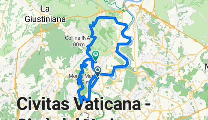
Labaro e Monte Mario
Ruta ciclista en Roma, Región de Lacio, Italia
- 34,7 km
- Distancia
- 548 m
- Ascenso
- 513 m
- Descenso

Route to Milan
Ruta ciclista en Roma, Región de Lacio, Italia
- 713,6 km
- Distancia
- 8700 m
- Ascenso
- 8620 m
- Descenso
De nuestros editores
Las mejores rutas ciclistas en y alrededor de Roma

If you are looking for endless beaches in their natural state, Fuerteventura is the place to go. The second largest of the Canary Islands is characterized by a unique landscape composed of rock formations, sand and oases. It may not be as hilly as Tenerife, but winds can present a challenge for cyclists. Fuerteventura translates to “strong wind”: the Canary Islands sit in the path of north-eastern trade winds, which help fend off the hot Sahara air.


The easternmost of the Canary Islands is Lanzarote. Famous for its rugged volcanic landscapes, rock formations and sand beaches, cyclists come here for the flatter road routes. The highest point of the elongated island is at just 671 meters (2201 ft). Like in Fuerteventura, it is good to be prepared for the conditions to be windy. Less busy routes and an exceptional prehistoric setting are the reward.


Known as “The Isle of Eternal Spring”, Tenerife is warm and pleasant year-round. In its center rises majestic Pico del Teide, at 3718 m (12198 ft) the highest peak in Spain, and also an active volcano which last erupted in 1909. The towns and beaches of the largest of the Canary Islands are well-known tourist hotspots but there is plenty of stunning natural scenery to discover off the beaten path. From gentle coastal routes to seriously challenging mountain tours, there is something here to satisfy any cycling preference.
- Santa Cruz-Teide-und zurück
- 127 km
- 4223 m
- 3569 m
- Santa Cruz de Tenerife, Comunidad Autónoma de Canarias, España


Gran Canaria is a round island, 50 kilometers (30 miles) in diameter. Full of beaches, nature reserves and natural monuments, the second most populated Canary island markets itself as a fine-weather gym. Start at the coast and go inland for a steady uphill climb to the highest point at approximately 2000 meters (6500 ft). Steep ascents and hairpin turns are reminiscent of Alpine road biking, and attract athletic riders. If you feel up for it, push your limits in the legendary Valley of the Tears!
The Valley of Tears and Tamadaba Natural Park
- Gran Canaria, San Nicolas-Agaete

- 36,3 km
- 981 m
- 1038 m
- San Nicolás, Comunidad Autónoma de Canarias, España


These “other” Canary Islands also deserve an honourable mention. La Palma, arguably the prettiest island (Madonna knew all about "La Isla Bonita"), is an insider’s tip for cycling on all levels. With a huge variety of trails on mountain terrain to choose from, riders of all levels will find what they came for here. The hilly, sometimes forested scenery on La Gomera and the “end of the world” feeling on the mostly deserted roads of El Hierro also attract dedicated cyclists.
Routes in La Palma, La Gomera and El Hierro
- Santa Cruz de la Palma - Roque de los Muchachos + back - 2009. April

- 86,5 km
- 2629 m
- 2632 m
- Santa Cruz de La Palma, Comunidad Autónoma de Canarias, España
- Ruta El Hierro 1, Salida en la cumbre
- 71,9 km
- 1218 m
- 2327 m
- Frontera, Comunidad Autónoma de Canarias, España


Descubre más rutas
- Rome - Fiuggi
- 50 km
- 808 m
- 379 m
- Roma, Región de Lacio, Italia
- Rom - Monteleone Sabino
- 63 km
- 1405 m
- 989 m
- Roma, Región de Lacio, Italia
- Ciampino - Frosinone
- 80,7 km
- 1787 m
- 1430 m
- Roma, Región de Lacio, Italia
- Rom - Valmontone
- 54,5 km
- 810 m
- 547 m
- Roma, Región de Lacio, Italia
- Roma - Magliano Romano
- 46,2 km
- 639 m
- 428 m
- Roma, Región de Lacio, Italia
- Rom - Civita Castellana
- 66 km
- 941 m
- 831 m
- Roma, Región de Lacio, Italia
- Trail dei Papi 2024
- 599,7 km
- 10.410 m
- 10.410 m
- Roma, Región de Lacio, Italia
- Rome to Pisa with Florence (different route)
- 418,6 km
- 4640 m
- 4666 m
- Roma, Región de Lacio, Italia


Rutas desde Roma
Bikepacking de
De Roma a Nápoles
Excursión ciclista de un día de
De Roma a Vitinia
Excursión ciclista de un día de
De Roma a Castel Gandolfo
Rutas hacia Roma
Bikepacking de
De Bolsena a Roma
Excursión ciclista de un día de
De Vitinia a Roma
Excursión ciclista de un día de
De Sutri a Roma