
Parsons en bici
Descubre un mapa con 26 rutas y senderos en bici cerca de Parsons, creados por nuestra comunidad.
Retrato de la región
Conoce Parsons
Encuentra la ruta en bicicleta ideal para ti en Parsons, donde tenemos 26 rutas ciclistas para explorar.
1358 km
Distancia registrada
26
Rutas ciclistas
1485
Población


De nuestra comunidad
Las mejores rutas en bici en y alrededor de Parsons
Allegheny Highlands Trail of Wv, Parsons to Main St, Parsons
Ruta ciclista en Parsons, Virginia Occidental, Estados Unidos
- 42,2 km
- Distancia
- 531 m
- Ascenso
- 527 m
- Descenso

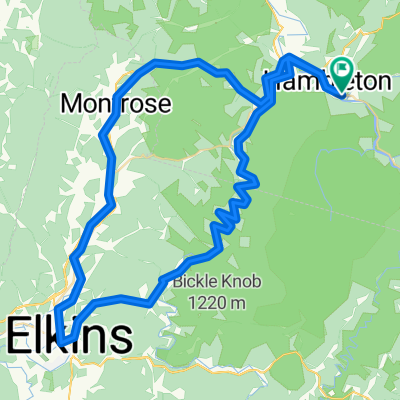
Limestone Mt. Loop
Ruta ciclista en Parsons, Virginia Occidental, Estados Unidos
- 33,4 km
- Distancia
- 587 m
- Ascenso
- 587 m
- Descenso

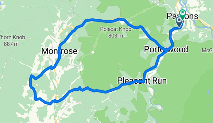
Parsons-Montrose Loop
Ruta ciclista en Parsons, Virginia Occidental, Estados Unidos
- 61,5 km
- Distancia
- 604 m
- Ascenso
- 602 m
- Descenso

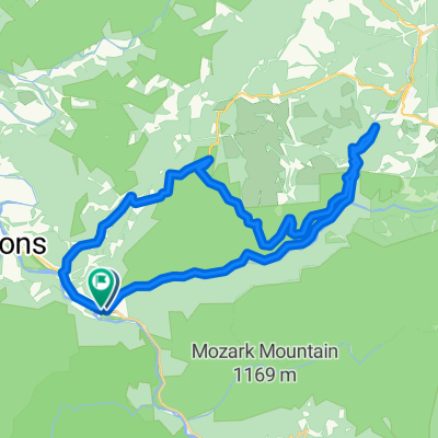
Horseshoe - Limestone Mt. Ride
Ruta ciclista en Parsons, Virginia Occidental, Estados Unidos
- 55 km
- Distancia
- 677 m
- Ascenso
- 677 m
- Descenso
Descubre más rutas
 Texas Mountain
- Distancia
- 34,7 km
- Ascenso
- 502 m
- Descenso
- 502 m
- Ubicación
- Parsons, Virginia Occidental, Estados Unidos
 Pifer Mountain Loop
- Distancia
- 31,4 km
- Ascenso
- 557 m
- Descenso
- 557 m
- Ubicación
- Parsons, Virginia Occidental, Estados Unidos
 Backbone Mountain Climb
- Distancia
- 8,7 km
- Ascenso
- 534 m
- Descenso
- 26 m
- Ubicación
- Parsons, Virginia Occidental, Estados Unidos
 Olson Fire Tower to Parsons
- Distancia
- 35,8 km
- Ascenso
- 96 m
- Descenso
- 710 m
- Ubicación
- Parsons, Virginia Occidental, Estados Unidos
 BW falls to Parsons to Deck Creek to apt
- Distancia
- 124,3 km
- Ascenso
- 959 m
- Descenso
- 1571 m
- Ubicación
- Parsons, Virginia Occidental, Estados Unidos
 Route in Hendricks
- Distancia
- 83,8 km
- Ascenso
- 1531 m
- Descenso
- 1531 m
- Ubicación
- Parsons, Virginia Occidental, Estados Unidos
 Bfalls to Moundsville
- Distancia
- 201,5 km
- Ascenso
- 1391 m
- Descenso
- 2151 m
- Ubicación
- Parsons, Virginia Occidental, Estados Unidos
 Second St, Hendricks to Allegheny Highlands Trail of Wv, Hendricks
- Distancia
- 39,5 km
- Ascenso
- 798 m
- Descenso
- 794 m
- Ubicación
- Parsons, Virginia Occidental, Estados Unidos