
Saint Paul en bici
Descubre un mapa con 491 rutas y senderos en bici cerca de Saint Paul, creados por nuestra comunidad.
Retrato de la región
Conoce Saint Paul
Encuentra la ruta en bicicleta ideal para ti en Saint Paul, donde tenemos 491 rutas ciclistas para explorar. La mayoría de la gente sale en bicicleta por aquí en los meses de junio y agosto.
20.564 km
Distancia registrada
491
Rutas ciclistas
285.068
Población
Comunidad
Usuarios más activos en Saint Paul


De nuestra comunidad
Las mejores rutas en bici en y alrededor de Saint Paul

River Ramble 20
Ruta ciclista en Saint Paul, Minnesota, Estados Unidos
- 29,6 km
- Distancia
- 196 m
- Ascenso
- 197 m
- Descenso

B2B00368 55102 > 55417 via Shepard Rd, Godfrey, Minnehaha, River Pkwy
Ruta ciclista en Saint Paul, Minnesota, Estados Unidos
- 17,8 km
- Distancia
- 96 m
- Ascenso
- 119 m
- Descenso

B2B00192 55102>55404viaShepherdRd/MissBlvd/WRiverPkwy/MidtwnGrnway
Ruta ciclista en Saint Paul, Minnesota, Estados Unidos
- 21,8 km
- Distancia
- 131 m
- Ascenso
- 86 m
- Descenso

B2B00418 55117>55123 via Cedar, Wabasha, Lexington, Pilot Knob Rd
Ruta ciclista en Saint Paul, Minnesota, Estados Unidos
- 20,8 km
- Distancia
- 161 m
- Ascenso
- 156 m
- Descenso
Descubre más rutas
 B2B00062 55106 - 55075 via Concord, NURT
- Distancia
- 9,5 km
- Ascenso
- 80 m
- Descenso
- 110 m
- Ubicación
- Saint Paul, Minnesota, Estados Unidos
 St Paul Gateway to: Brown’s creek to Stillwater and back .
- Distancia
- 64,2 km
- Ascenso
- 408 m
- Descenso
- 409 m
- Ubicación
- Saint Paul, Minnesota, Estados Unidos
 Gateway State Trail
- Distancia
- 30 km
- Ascenso
- 115 m
- Descenso
- 69 m
- Ubicación
- Saint Paul, Minnesota, Estados Unidos
 To the River Center
- Distancia
- 17,1 km
- Ascenso
- 117 m
- Descenso
- 90 m
- Ubicación
- Saint Paul, Minnesota, Estados Unidos
 B2B00024 55104 > 55121 via Big Rivers Trail
- Distancia
- 16,8 km
- Ascenso
- 174 m
- Descenso
- 174 m
- Ubicación
- Saint Paul, Minnesota, Estados Unidos
 Jackson Street to East 7th Street
- Distancia
- 1,6 km
- Ascenso
- 36 m
- Descenso
- 0 m
- Ubicación
- Saint Paul, Minnesota, Estados Unidos
 Way to Church
- Distancia
- 13,2 km
- Ascenso
- 54 m
- Descenso
- 37 m
- Ubicación
- Saint Paul, Minnesota, Estados Unidos
 B2B00629 55102 < 55402 via Summit, River Road, West bank, Downtown
- Distancia
- 15,5 km
- Ascenso
- 82 m
- Descenso
- 94 m
- Ubicación
- Saint Paul, Minnesota, Estados Unidos
Rutas hacia Saint Paul
Excursión ciclista de un día de
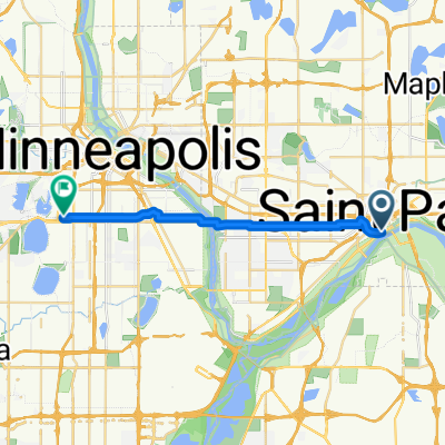
De Mineápolis a Saint Paul
Paseo rápido en bici de
De Falcon Heights a Saint Paul