
Smokey Point en bici
Descubre un mapa con 19 rutas y senderos en bici cerca de Smokey Point, creados por nuestra comunidad.
Retrato de la región
Conoce Smokey Point
Encuentra la ruta en bicicleta ideal para ti en Smokey Point, donde tenemos 19 rutas ciclistas para explorar. La mayoría de la gente sale en bicicleta por aquí en el mes de mayo.
569 km
Distancia registrada
19
Rutas ciclistas
1572
Población
Comunidad
Usuarios más activos en Smokey Point


De nuestra comunidad
Las mejores rutas en bici en y alrededor de Smokey Point


Arlington to Seattle
Ruta ciclista en Smokey Point, Washington, Estados Unidos
- 97,6 km
- Distancia
- 1514 m
- Ascenso
- 1459 m
- Descenso

Easy ride in Arlington
Ruta ciclista en Smokey Point, Washington, Estados Unidos
- 40,9 km
- Distancia
- 196 m
- Ascenso
- 195 m
- Descenso
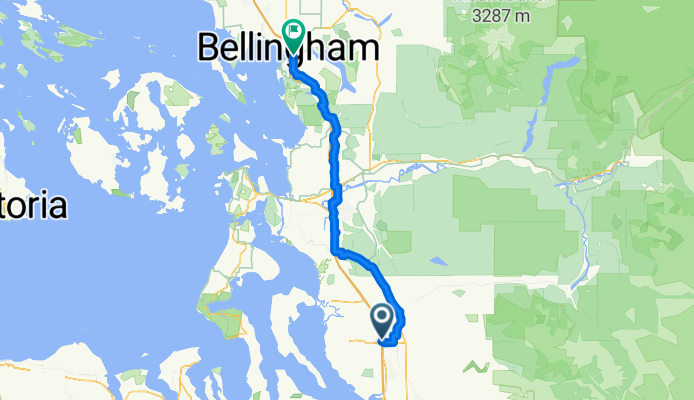
172nd St NE, Arlington to Lakeway Dr, Bellingham
Ruta ciclista en Smokey Point, Washington, Estados Unidos
- 93,7 km
- Distancia
- 604 m
- Ascenso
- 593 m
- Descenso
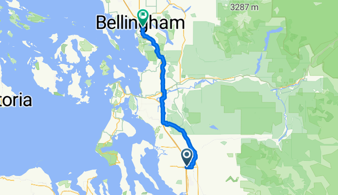
Smokey Point Dr, Arlington to Lakeway Dr, Bellingham
Ruta ciclista en Smokey Point, Washington, Estados Unidos
- 92,3 km
- Distancia
- 964 m
- Ascenso
- 952 m
- Descenso
Descubre más rutas
 15405 67th Ave NE, Arlington to 15405 67th Ave NE, Arlington
- Distancia
- 10,9 km
- Ascenso
- 69 m
- Descenso
- 70 m
- Ubicación
- Smokey Point, Washington, Estados Unidos
 15405 67th Ave NE, Arlington to 15405 67th Ave NE, Arlington
- Distancia
- 11,1 km
- Ascenso
- 74 m
- Descenso
- 72 m
- Ubicación
- Smokey Point, Washington, Estados Unidos
 18828 Smokey Point Blvd, Arlington to 14714–14798 Summers Dr, Mount Vernon
- Distancia
- 42,1 km
- Ascenso
- 330 m
- Descenso
- 348 m
- Ubicación
- Smokey Point, Washington, Estados Unidos
 15291–15359 67th Ave NE, Arlington to 15405 67th Ave NE, Arlington
- Distancia
- 5,2 km
- Ascenso
- 23 m
- Descenso
- 23 m
- Ubicación
- Smokey Point, Washington, Estados Unidos
 15405 67th Ave NE, Arlington to 15405 67th Ave NE, Arlington
- Distancia
- 11,1 km
- Ascenso
- 65 m
- Descenso
- 66 m
- Ubicación
- Smokey Point, Washington, Estados Unidos
 15405 67th Ave NE, Arlington to 15405 67th Ave NE, Arlington
- Distancia
- 13 km
- Ascenso
- 118 m
- Descenso
- 116 m
- Ubicación
- Smokey Point, Washington, Estados Unidos
 15405 67th Ave NE, Arlington to 15405 67th Ave NE, Arlington
- Distancia
- 11,1 km
- Ascenso
- 86 m
- Descenso
- 87 m
- Ubicación
- Smokey Point, Washington, Estados Unidos
 hdjdj
hdjdj- Distancia
- 29,1 km
- Ascenso
- 653 m
- Descenso
- 634 m
- Ubicación
- Smokey Point, Washington, Estados Unidos