
South Croydon en bici
Descubre un mapa con 422 rutas y senderos en bici cerca de South Croydon, creados por nuestra comunidad.
Retrato de la región
Conoce South Croydon
Encuentra la ruta en bicicleta ideal para ti en South Croydon, donde tenemos 422 rutas ciclistas para explorar. La mayoría de la gente sale en bicicleta por aquí en los meses de mayo y junio.
11.175 km
Distancia registrada
422
Rutas ciclistas
55.198
Población
Comunidad
Usuarios más activos en South Croydon
De nuestra comunidad
Las mejores rutas en bici en y alrededor de South Croydon
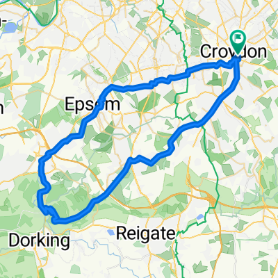
South Croydon, Botley Godstone, Merstham, Chipstead Loop
Ruta ciclista en South Croydon, England, United Kingdom
A thirty mile loop largely on fairly busy roads but still a good fun ride.<br /><br />Kent Gate Way can be avoided using the cycle path picked up at the bottom of Gravel Hill that runs along Addington Village Road.
The route is pretty hilly, Layhams Road is a category four climb and it's worth noting that Chalk Pit Lane is very steep (check your brakes before descending). Howe Lane is also pretty steep and there is often gravel on the right hand corner at the bottom.
On Markedge Lane you pass Fannys Farm Shop which is always a good refueling place.
- 54,4 km
- Distancia
- 526 m
- Ascenso
- 526 m
- Descenso
East Croydon - Botley Hill 37KM
Ruta ciclista en South Croydon, England, United Kingdom
- 36,7 km
- Distancia
- 373 m
- Ascenso
- 369 m
- Descenso
Croydon, Layhams Road, Botley, Redhill, Dorking, Box HIll loop
Ruta ciclista en South Croydon, England, United Kingdom
This is my next planned route, I've ridden nearly all of the component parks (haven't got from Pebblehill Road to Dorking and out to Box Hill yet) but this should be a great route in the summer.
- 79,1 km
- Distancia
- 580 m
- Ascenso
- 580 m
- Descenso
South Croydon, Banstead, Box Hill, Reigate Loop
Ruta ciclista en South Croydon, England, United Kingdom
A slightly longer version of my normal route to Box Hill.
<span style="font-family: Arial, Helvetica, sans-serif; font-size: 11px;">Where Garratts Lane joins the A217 I normally cross the road at the traffic lights. You can either follow the map the way it shows along The Drive and then take the first left, ride through Nork Park and do a left right at the end or ride down the small residential road alongside the A217 and turn right at the lights.</span>
On the climb up Markedge Lane on the way home you pass Fannys Farm Shop which is always a good place to refuel.
- 62,8 km
- Distancia
- 509 m
- Ascenso
- 509 m
- Descenso
Descubre más rutas
- Purley Way 403A to Ship Street
- Distancia
- 57,7 km
- Ascenso
- 455 m
- Descenso
- 373 m
- Ubicación
- South Croydon, England, United Kingdom
- Road-Biggin Hill & Boxhill from East Croydon
- Distancia
- 96,7 km
- Ascenso
- 693 m
- Descenso
- 693 m
- Ubicación
- South Croydon, England, United Kingdom
- Figure of 8
- Distancia
- 29,5 km
- Ascenso
- 330 m
- Descenso
- 330 m
- Ubicación
- South Croydon, England, United Kingdom
- Croydon to Greenwich ( Via Cycle Route 21)
- Distancia
- 17,8 km
- Ascenso
- 4 m
- Descenso
- 83 m
- Ubicación
- South Croydon, England, United Kingdom
- London-Crydon nach Dover
- Distancia
- 140,6 km
- Ascenso
- 1047 m
- Descenso
- 1038 m
- Ubicación
- South Croydon, England, United Kingdom
- 680 Purley Way, Croydon to Brighton Railway Station, Queen's Road, Brighton
- Distancia
- 70 km
- Ascenso
- 359 m
- Descenso
- 380 m
- Ubicación
- South Croydon, England, United Kingdom
- Day 4 BTN to Paris
- Distancia
- 73,6 km
- Ascenso
- 383 m
- Descenso
- 414 m
- Ubicación
- South Croydon, England, United Kingdom
- Croydon via Tooting Bec Common return
- Distancia
- 16,3 km
- Ascenso
- 42 m
- Descenso
- 93 m
- Ubicación
- South Croydon, England, United Kingdom
Rutas desde South Croydon
Paseo rápido en bici de
De South Croydon a Purley
Rutas hacia South Croydon
Paseo rápido en bici de
De Purley a South Croydon