
Glenelg East en bici
Descubre un mapa con 79 rutas y senderos en bici cerca de Glenelg East, creados por nuestra comunidad.
Retrato de la región
Conoce Glenelg East
Encuentra la ruta en bicicleta ideal para ti en Glenelg East, donde tenemos 79 rutas ciclistas para explorar. La mayoría de la gente sale en bicicleta por aquí en los meses de febrero y junio.
3017 km
Distancia registrada
79
Rutas ciclistas
3701
Población
Comunidad
Usuarios más activos en Glenelg East


De nuestra comunidad
Las mejores rutas en bici en y alrededor de Glenelg East

Camden Park - Marino Rocks - City Loop
Ruta ciclista en Glenelg East, State of South Australia, Australia
- 48,3 km
- Distancia
- 241 m
- Ascenso
- 239 m
- Descenso

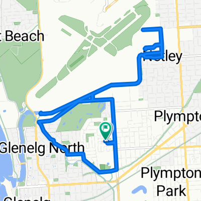
Easty ride west to Adelaide cityRoute to work
Ruta ciclista en Glenelg East, State of South Australia, Australia
- 9 km
- Distancia
- 50 m
- Ascenso
- 8 m
- Descenso

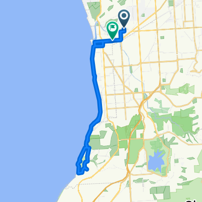
Glenelg East to the Blanche Harbour Shacks
Ruta ciclista en Glenelg East, State of South Australia, Australia
- 337,4 km
- Distancia
- 392 m
- Ascenso
- 397 m
- Descenso

Margie’s Way
Ruta ciclista en Glenelg East, State of South Australia, Australia
- 9,9 km
- Distancia
- 36 m
- Ascenso
- 0 m
- Descenso
Descubre más rutas
 42.5km along River Torrens/Mike Turtur
- Distancia
- 42,5 km
- Ascenso
- 196 m
- Descenso
- 194 m
- Ubicación
- Glenelg East, State of South Australia, Australia
 Training - Home - Norton Summit - Lofty
- Distancia
- 59,2 km
- Ascenso
- 695 m
- Descenso
- 693 m
- Ubicación
- Glenelg East, State of South Australia, Australia
 Camden Park to Dernancourt along the River Torrens
- Distancia
- 54,1 km
- Ascenso
- 204 m
- Descenso
- 204 m
- Ubicación
- Glenelg East, State of South Australia, Australia
 Camden Park to Willunga Hill
- Distancia
- 98 km
- Ascenso
- 1186 m
- Descenso
- 1185 m
- Ubicación
- Glenelg East, State of South Australia, Australia
 Scott Court to Scott Court
- Distancia
- 17,5 km
- Ascenso
- 37 m
- Descenso
- 39 m
- Ubicación
- Glenelg East, State of South Australia, Australia
 451 ANZAC Highway, Camden Park to 46 Clifton Street, Camden Park
- Distancia
- 28,2 km
- Ascenso
- 6 m
- Descenso
- 14 m
- Ubicación
- Glenelg East, State of South Australia, Australia
 Pine ave to south tce - Mike Turtur Bikeway
- Distancia
- 18,6 km
- Ascenso
- 61 m
- Descenso
- 61 m
- Ubicación
- Glenelg East, State of South Australia, Australia
 Slow ride in Camden Park
- Distancia
- 32,5 km
- Ascenso
- 13 m
- Descenso
- 22 m
- Ubicación
- Glenelg East, State of South Australia, Australia