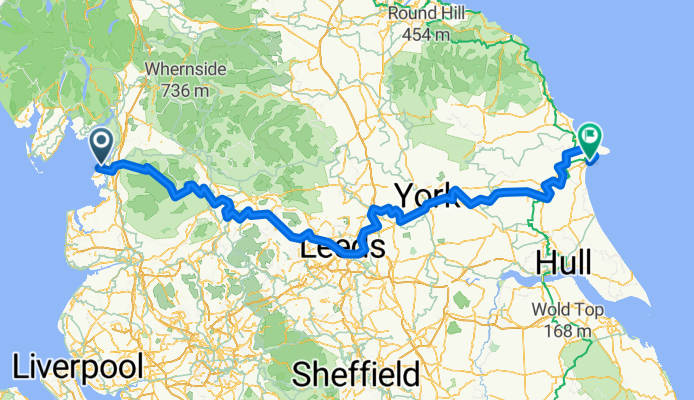
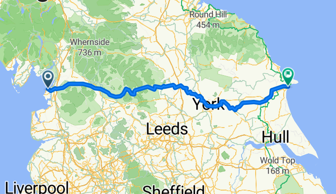
Ruta ciclista en Morecambe, Inglaterra, Reino Unido
This route is of my trip this summer based on my variation of the Sustrans Way of the Roses route. I wanted to stay overnight in Crayke, others will probably have other priorities. I will make corrections if I find any errors.
September 2011
<span style="font-family: Arial,sans-serif;"><font size="4">Morecambe to Bridlington in 3 days<br /></font></span>
<span style="font-family: Arial,sans-serif;"><font size="3">Morecambe</font></span>
<span style="font-family: Arial,sans-serif;"><font size="3">The
start is on promenade near Midland Hotel and at rdbt cross Marine Rd
then down Central Dr to <span style="font-weight: normal;">d</span><span style="font-weight: normal;">ismount </span><span style="font-weight: normal;">in</span> 250yds for R <span style="font-weight: normal;">at </span>crossings before rdbt.</font></span>
<span style="font-family: Arial,sans-serif;"><font size="3">Bear
right at Frankie and Benny's to access cyclepath on right of rly
line.</font></span>
<span style="font-family: Arial,sans-serif;"><font size="3"><span style="font-weight: normal;">In
0.4m</span> L across rly line and cont over Winsfell View and
Out Moss Ln</font></span>
<span style="font-family: Arial,sans-serif;"><font size="3">In
2.6m cross Millennium Bridge over River Lune and fork L <span style="font-weight: normal;">to </span><span style="font-weight: normal;">cont on</span><span style="font-weight: normal;"> </span><span style="font-weight: normal;">cyclepath.</span></font></span>
<span style="font-family: Arial,sans-serif;"><font size="3"><span style="font-weight: normal;">Cont </span><span style="font-weight: normal;">for </span><span style="font-weight: normal;">5</span><span style="font-weight: normal;">m </span><span style="font-weight: normal;">(</span><span style="font-weight: normal;">passing </span><span style="font-weight: normal;">under M6, </span><span style="font-weight: normal;">over</span><span style="font-weight: normal;"> loop of River Lune and thru Caton) </span><span style="font-weight: normal;">to</span></font></span>
<span style="font-family: Arial,sans-serif;"><font size="3">R <span style="font-weight: normal;"> </span><span style="font-weight: normal;">leaving
cyclepath to </span><span style="font-weight: normal;">cross A683 </span><span style="font-weight: normal;">and
up</span><span style="font-weight: normal;"> Holme Ln to</span></font></span>
<span style="font-family: Arial,sans-serif;"><font size="4">Brookhouse</font></span>
<span style="font-family: Arial,sans-serif;"><font size="3">In
0.28m L across small bridge to L on Brookhouse Rd for
1.4m then R on A683 for 1.6m.</font></span>
<span style="font-family: Arial,sans-serif;"><font size="3">Turn
R on B6480 for 1.6m to</font></span>
<span style="font-family: Arial,sans-serif;"><font size="4">Wray</font></span>
<span style="font-family: Arial,sans-serif;"><font size="3">In
centre R onto Main Street (sp Lowgill/High Tathham) for 2.5m
to</font></span>
<span style="font-family: Arial,sans-serif;"><font size="3">R (sp Lowgill/High Tathham) then in 200yds L (sp Settle 12m)</font></span>
<span style="font-family: Arial,sans-serif;"><font size="3">In
2m SO across High Bentham-Slaidburn road</font></span>
<span style="font-family: Arial,sans-serif;"><font size="3">In
3.8m SO passing Keasden Church and across Clapham-Slaidburn
road</font></span>
<span style="font-family: Arial,sans-serif;"><font size="3">In1.3m
SO under Settle-Carlisle rly then bear right</font></span>
<span style="font-family: Arial,sans-serif;"><font size="3">SO for 1.5m passing Eldroth to re-cross rly bridge</font></span>
<span style="font-family: Arial,sans-serif;"><font size="3">SO for 1.5m to cross over rly bridge near Armidstead Hall</font></span>
<span style="font-family: Arial,sans-serif;"><font size="3">In
460yds at x-rds R (sp Settle) then SO for 1.6m
to pass under rly by </font></span>
<span style="font-family: Arial,sans-serif;"><font size="4">Giggleswick
Station</font></span>
<span style="font-family: Arial,sans-serif;"><font size="3">R on A65 for 0.3m then next R to pass under rly for 1.7m to</font></span>
<span style="font-family: Arial,sans-serif;"><font size="4">Rathmell</font></span>
<span style="font-family: Arial,sans-serif;"><font size="3">SO<span style="font-weight: normal;"> for 2m to </span>Wigglesworth <span style="font-weight: normal;">where </span><span style="font-weight: normal;">sharp </span>L <span style="font-weight: normal;">on
B6478 (SP Long Preston) </span></font></span>
<span style="font-family: Arial,sans-serif;"><font size="3"><span style="font-weight: normal;">In
abt 1m cross River Ribble then </span><span style="font-weight: normal;">next </span>R <span style="font-weight: normal;">(sp Hellifield </span><span style="font-weight: normal;">but </span><span style="font-weight: normal;">sign </span><span style="font-weight: normal;">might
be </span><span style="font-weight: normal;">rotated)</span></font></span>
<span style="font-family: Arial,sans-serif;"><font size="3"><span style="font-weight: normal;">In
0.8m</span><span style="font-weight: normal;"> </span>R<span style="font-weight: normal;"> on A682 </span><span style="font-weight: normal;">for 0.3m t</span><span style="font-weight: normal;">hen</span><span style="font-weight: normal;"> </span><span style="font-weight: normal;">just after caravan park turn </span>L <span style="font-weight: normal;">onto gated rd</span></font></span>
<span style="font-family: Arial,sans-serif;"><font size="3"><span style="font-weight: normal;">In
about 0.3m </span>R <span style="font-weight: normal;">on A65 </span><span style="font-weight: normal;">into</span></font></span>
<span style="font-family: Arial,sans-serif;"><font size="4">Hellifield</font></span>
<span style="font-family: Arial,sans-serif;"><font size="3">SO then soon after 30mph sign L (sp Malham/Airton) then 1.8m to</font></span>
<span style="font-family: Arial,sans-serif;"><font size="4">Otterburn</font></span>
<span style="font-family: Arial,sans-serif;"><font size="3">SO<span style="font-weight: normal;"> for 1.6m to </span>Airton <span style="font-weight: normal;">then</span><span style="font-weight: normal;"> </span>SO <span style="font-weight: normal;">(sp
Calton/Winterburn/Hetton) </span><span style="font-weight: normal;">for
2.3m to </span>L<span style="font-weight: normal;"> at TJ into </span><font size="4">Winterburn</font></font></span>
<span style="font-family: Arial,sans-serif;"><font size="3">Cont
for 2m to</font></span>
<span style="font-family: Arial,sans-serif;"><font size="3"><font size="4">Hetton</font><font size="4"> </font></font></span>
<span style="font-family: Arial,sans-serif;"><font size="3">L to join rd from
Flasby then SO thru <font size="4">Cracoe </font><font size="4">to</font><font size="4"> </font>L onto B6265</font></span>
<span style="font-family: Arial,sans-serif;"><font size="3"><span style="font-weight: normal;">In
0.5m as road bends left </span>R <span style="font-weight: normal;">(eff
SO) to climb and 2.5m </span><span style="font-weight: normal;">bear
right </span>R <span style="font-weight: normal;">to</span></font></span>
<span style="font-family: Arial,sans-serif;"><font size="4">Thorpe</font></span>
<span style="font-family: Arial,sans-serif;"><font size="3">bear
left thru village then in 0.45m R onto B6160 to</font></span>
<span style="font-family: Arial,sans-serif;"><font size="4">Burnsell</font></span>
<span style="font-family: Arial,sans-serif;"><font size="3">R to cross bridge over River Wharfe to</font></span>
<span style="font-family: Arial,sans-serif;"><font size="4">Appletreewick </font></span>
<span style="font-family: Arial,sans-serif;"><font size="3">In
0.3m after village R (sp Bardon/Bolton Abbey/Skipton)</font></span>
<span style="font-family: Arial,sans-serif;"><font size="3">After
1.6m at Bardon L (sp Hazelwood/Storiths)</font></span>
<span style="font-family: Arial,sans-serif;"><font size="3">In
2.25m R across wooden bridge over River Wharfe by Cavendish
Pavilion</font></span>
<span style="font-family: Arial,sans-serif;"><font size="3">Thru
car park to L on B6160 for 1m passing Bolton Abbey to</font></span>
<span style="font-family: Arial,sans-serif;"><font size="4">Bolton
Abbey</font></span>
<span style="font-family: Arial,sans-serif;"><font size="4"><font size="3"><span style="font-weight: normal;">Soon
after </span></font><font size="3"><span style="font-weight: normal;">Devonshire
Arms </span></font><font size="3"><span style="font-weight: normal;">turn </span></font><font size="3">L</font><font size="3"><span style="font-weight: normal;"> at rdbt onto busy A59 for 650yds to </span></font><font size="3">R</font><font size="3"><span style="font-weight: normal;"> to</span></font></font></span>
<span style="font-family: Arial,sans-serif;"><font size="4">Beamsley</font></span>
<span style="font-family: Arial,sans-serif;"><font size="3">Cont
for 4m thru Nesfield and past Ilkley Golf Course to R at TJ and into </font></span>
<span style="font-family: Arial,sans-serif;"><font size="4">Ilkley</font></span>
<span style="font-family: Arial,sans-serif;"><font size="3">SO <span style="font-weight: normal;">(L&R) at x-rds </span><span style="font-weight: normal;">for
3.4m </span><span style="font-weight: normal;">past sports grounds </span><span style="font-weight: normal;">and </span><span style="font-weight: normal;">by River Wharfe </span><span style="font-weight: normal;">initially
then climb to</span></font></span>
<span style="font-family: Arial,sans-serif;"><font size="4">Askwith</font></span>
<span style="font-family: Arial,sans-serif;"><font size="3">L (sp Askwith Village Hall) up hill for 1.4m to L at x-rds for
2m to R (sp Timble) then SO in 360yds thru</font></span>
<span style="font-family: Arial,sans-serif;"><font size="4">Timble</font></span>
<span style="font-family: Arial,sans-serif;"><font size="3">Cont
down hill to R at TJ and across top of Fewston Dam to next L </font></span>
<span style="font-family: Arial,sans-serif;"><font size="3">SO up hill sp Pately Bridge (not sharp left sp Skipton) to SO at
x-rds (sp Harrogate)</font></span>
<span style="font-family: Arial,sans-serif;"><font size="3">In
0.5m sharp L on B6451 then R in 355yds on Penny Pot Ln
(sp Harrogate)</font></span>
<span style="font-family: Arial,sans-serif;"><font size="3">L in 0.8m then after 0.6m L then R across busy A59 sp Kettlesing/Birstwith to</font></span>
<span style="font-family: Arial,sans-serif;"><font size="4">Kettlesing</font></span>
<span style="font-family: Arial,sans-serif;"><font size="3"><span style="font-weight: normal;">Bear </span><span style="font-weight: normal;">left</span><span style="font-weight: normal;"> </span><span style="font-weight: normal;">to </span>L <span style="font-weight: normal;">at
TJ </span><span style="font-weight: normal;">(</span><span style="font-weight: normal;">by
War Memorial</span><span style="font-weight: normal;">)</span><span style="font-weight: normal;"> </span><span style="font-weight: normal;">sp Birstwith.</span></font></span>
<span style="font-family: Arial,sans-serif;"><font size="3"><span style="font-weight: normal;">Bear
left</span><span style="font-weight: normal;"> </span><span style="font-weight: normal;">in</span><span style="font-weight: normal;"> 1m </span><span style="font-weight: normal;">then after short climb</span><span style="font-weight: normal;"> </span>R<span style="font-weight: normal;"> at TJ then imm </span>R<span style="font-weight: normal;"> </span><span style="font-weight: normal;">to</span></font></span>
<span style="font-family: Arial,sans-serif;"><font size="4">Hampsthwaite</font></span>
<span style="font-family: Arial,sans-serif;"><font size="3">L<span style="font-weight: normal;"> </span><span style="font-weight: normal;">in village </span><span style="font-weight: normal;">to</span><span style="font-weight: normal;"> </span><span style="font-weight: normal;">bridge </span><span style="font-weight: normal;">over</span><span style="font-weight: normal;"> River Nidd </span><span style="font-weight: normal;">and up the hill</span></font></span>
<span style="font-family: Arial,sans-serif;"><font size="3"><span style="font-weight: normal;">After </span><span style="font-weight: normal;">0.</span><span style="font-weight: normal;">6</span><span style="font-weight: normal;">m </span><span style="font-weight: normal;">sharp </span>R <span style="font-weight: normal;">on</span><span style="font-weight: normal;">to </span><span style="font-weight: normal;">narrow </span><span style="font-weight: normal;">lane </span><span style="font-weight: normal;">(</span><span style="font-weight: normal;">turn</span><span style="font-weight: normal;"> </span><span style="font-weight: normal;">is just </span><span style="font-weight: normal;">after
triple garage of large white house</span><span style="font-weight: normal;">)</span></font></span>
<span style="font-family: Arial,sans-serif;"><font size="3"><span style="font-weight: normal;">I</span><span style="font-weight: normal;">n</span><span style="font-weight: normal;"> 0.5m </span><span style="font-weight: normal;">thru gate </span><span style="font-weight: normal;">on</span><span style="font-weight: normal;"> path </span><span style="font-weight: normal;">through wood past
Ripley Castle </span><span style="font-weight: normal;">( </span><span style="font-weight: normal;">a
bit </span><span style="font-weight: normal;">less </span><span style="font-weight: normal;">stony</span><span style="font-weight: normal;"> after 100yds)</span><span style="font-weight: normal;"> </span></font></span>
<span style="font-family: Arial,sans-serif;"><font size="4">Ripley</font></span>
<span style="font-family: Arial,sans-serif;"><font size="3">L <span style="font-weight: normal;">by Boar's Head Hotel</span> <span style="font-weight: normal;">to </span>L<span style="font-weight: normal;"> at rdbt on B6165 (sp Pately Bridge)</span></font></span>
<span style="font-family: Arial,sans-serif;"><font size="3">R<span style="font-weight: normal;"> in 0.6m (sp Fountains Abbey and Bishop Thornton) up hill.</span></font></span>
<span style="font-family: Arial,sans-serif;"><font size="3"><span style="font-weight: normal;">After
1.7m turn </span>R<span style="font-weight: normal;"> by
derelict inn. Cont for 2.7m </span><span style="font-weight: normal;">and</span><span style="font-weight: normal;"> thru </span>Markington<span style="font-weight: normal;"> </span><span style="font-weight: normal;">to </span>L <span style="font-weight: normal;">at </span><span style="font-weight: normal;">TJ </span><span style="font-weight: normal;">on</span><span style="font-weight: normal;"> A65 </span><span style="font-weight: normal;">at</span></font></span>
<span style="font-family: Arial,sans-serif;"><font size="4">Wormald
Green</font></span>
<span style="font-family: Arial,sans-serif;"><font size="3"><span style="font-weight: normal;">I</span><span style="font-weight: normal;">n
400yds </span><span style="font-weight: normal;">at top of hill </span>R <span style="font-weight: normal;">(sp Burton Leonard) </span><span style="font-weight: normal;">for
1.5m to </span></font></span>
<span style="font-family: Arial,sans-serif;"><font size="4">Burton
Leonard</font></span>
<span style="font-family: Arial,sans-serif;"><font size="3">Fork
R in village and past Royal Oak pub. In 1.4m bear right in
Copgrove then in 1m L to</font></span>
<span style="font-family: Arial,sans-serif;"><font size="4">Staveley</font></span>
<span style="font-family: Arial,sans-serif;"><font size="3">Bear
right (sp Arkendale) then 1m to SO across A6055 to</font></span>
<span style="font-family: Arial,sans-serif;"><font size="4">Arkendale</font></span>
<span style="font-family: Arial,sans-serif;"><font size="3">L<span style="font-weight: normal;"> at TJ then 1m to bridge over A1(M) to </span>L<span style="font-weight: normal;"> on A168 then next </span>R <span style="font-weight: normal;">(sp
Marton cum Grafton)</span></font></span>
<span style="font-family: Arial,sans-serif;"><font size="3"><span style="font-weight: normal;">In
1.8m </span>R<span style="font-weight: normal;"> at TJ on B6265
then next </span>L <span style="font-weight: normal;">(sp Upper
Dunsforth/ Greater Ouseburn) to</span></font></span>
<span style="font-family: Arial,sans-serif;"><font size="4">Greater
Ouseburn</font></span>
<span style="font-family: Arial,sans-serif;"><font size="3">SO thru village then L (sp Aldwark via toll bridge). In 1m cross
River Ouse then 1.8m to </font></span>
<span style="font-family: Arial,sans-serif;"><font size="4">Youlton</font></span>
<span style="font-family: Arial,sans-serif;"><font size="3">Bear
left then in 1m SO at x-rds (sp Alne/ Easingwold) for 0.38m to</font></span>
<span style="font-family: Arial,sans-serif;"><font size="4">Alne</font></span>
<span style="font-family: Arial,sans-serif;"><font size="3">Bear
right then SO for 3.7m then R into </font></span>
<span style="font-family: Arial,sans-serif;"><font size="4">Easingwold</font></span>
<span style="font-family: Arial,sans-serif;"><font size="3">SO at mini-rdb (sp Brandsby/Crayke). After 0.38m L then 2m to</font></span>
<span style="font-family: Arial,sans-serif;"><font size="4">Crayke</font></span>
<span style="font-family: Arial,sans-serif;"><font size="3">At
TJ either bear left to Durham Ox PH</font></span>
<span style="font-family: Arial,sans-serif;"><font size="3"><span style="font-weight: normal;">or
b</span><span style="font-weight: normal;">ear </span><span style="font-weight: normal;">right
at TJ</span><span style="font-weight: normal;"> (sp Stillington/Huby) </span><span style="font-weight: normal;">then </span><span style="font-weight: normal;">1.2m </span><span style="font-weight: normal;">to </span>L<span style="font-weight: normal;"> at TJ </span><span style="font-weight: normal;">then </span><span style="font-weight: normal;">1.4m </span><span style="font-weight: normal;">in</span><span style="font-weight: normal;">to</span></font></span>
<span style="font-family: Arial,sans-serif;"><font size="4">Stillington</font></span>
<span style="font-family: Arial,sans-serif;"><font size="3">R on B1363 for 1m then L (sp Sheriff Hutton/Strensall) for 3.2m
to L at TJ</font></span>
<span style="font-family: Arial,sans-serif;"><font size="3">In
0.87m R then 0.3m to </font></span>
<span style="font-family: Arial,sans-serif;"><font size="4">West
Lilling</font></span>
<span style="font-family: Arial,sans-serif;"><font size="3">R at TJ then SO for 2.8m, thru rly crossing then thru</font></span>
<span style="font-family: Arial,sans-serif;"><font size="4">Flaxton</font></span>
<span style="font-family: Arial,sans-serif;"><font size="3">SO for abt 1m to L at TJ with busy A64. (dismount and use
footpath opposite)</font></span>
<span style="font-family: Arial,sans-serif;"><font size="3">Walk
to next R in 450yds sp Claxton/Stamford Bridge) then SO for 1.63m thru Claxton to</font></span>
<span style="font-family: Arial,sans-serif;"><font size="4">Sand
Sutton</font></span>
<span style="font-family: Arial,sans-serif;"><font size="3"><font size="4">Enter
village and just after 30mph sign</font> L sp Stamford Bridge</font></span>
<span style="font-family: Arial,sans-serif;"><font size="3">SO for1.6m to R at TJ then in 430yds next L to</font></span>
<span style="font-family: Arial,sans-serif;"><font size="4">Stamford
Bridge</font></span>
<span style="font-family: Arial,sans-serif;"><font size="3">L across River Derwent use footbridge rather than the road</font></span>
<span style="font-family: Arial,sans-serif;"><font size="3">Bear
left then R just after Stamford Free House (sp Fangfosse/High
Catton/Low Catton)</font></span>
<span style="font-family: Arial,sans-serif;"><font size="3"><span style="font-weight: normal;">After
120yds </span>L <span style="font-weight: normal;">by church
(sp Full Sutton/Fangfoss)</span></font></span>
<span style="font-family: Arial,sans-serif;"><font size="3">SO for 2.7m to L at TJ (sp Fangfoss) then next R by
caravan site. In 1.67m L (sp Yapham)</font></span>
<span style="font-family: Arial,sans-serif;"><font size="3">In
1.24m R then, next L (sp Yapham/Bishop Wilton) to
by-pass Pocklington and leave WofR signed route. After 0.54m L at
TJ then SO thru</font></span>
<span style="font-family: Arial,sans-serif;"><font size="4">Yapham</font></span>
<span style="font-family: Arial,sans-serif;"><font size="3">Cont
for 0.75m to </font></span>
<span style="font-family: Arial,sans-serif;"><font size="4">Meltonby</font></span>
<span style="font-family: Arial,sans-serif;"><font size="3">R<span style="font-weight: normal;"> (sp Pocklington) then after 0.78m</span> L <span style="font-weight: normal;">(no
sp) </span><span style="font-weight: normal;">for 0.64m </span><span style="font-weight: normal;">to</span><span style="font-weight: normal;"> </span>L<span style="font-weight: normal;"> </span><span style="font-weight: normal;">(eff </span>SO<span style="font-weight: normal;">) re-joining WofR
route</span></font></span>
<span style="font-family: Arial,sans-serif;"><font size="3"><span style="font-weight: normal;">In
0.4m </span>R<span style="font-weight: normal;"> sp </span>Millington
Wood <span style="font-weight: normal;">then </span>SO<span style="font-weight: normal;"> </span><span style="font-weight: normal;">up Swineridge Hill</span></font></span>
<span style="font-family: Arial,sans-serif;"><font size="3"><span style="font-weight: normal;">Follow
narrow road for</span><span style="font-weight: normal;"> </span><span style="font-weight: normal;">4.</span><span style="font-weight: normal;">3</span><span style="font-weight: normal;">m </span><span style="font-weight: normal;">thru </span><font size="4">Millingto</font><font size="4">n </font><font size="4">Dale</font><font size="4"><span style="font-weight: normal;">, </span></font><font size="4"><span style="font-weight: normal;">climb</span></font><span style="font-weight: normal;"> </span><span style="font-weight: normal;">to </span>L <span style="font-weight: normal;">(sp
Huggate) for 1m t</span><span style="font-weight: normal;">hru</span></font></span>
<span style="font-family: Arial,sans-serif;"><font size="4">Huggate</font></span>
<span style="font-family: Arial,sans-serif;"><font size="3"><span style="font-weight: normal;">Cont
for 0.75m </span><span style="font-weight: normal;">to </span><span style="font-weight: normal;">bear
left then in 450yds</span> <span style="font-weight: normal;">fork</span> R <span style="font-weight: normal;">(sp Tib</span><span style="font-weight: normal;">thorpe</span><span style="font-weight: normal;">/Dr</span><span style="font-weight: normal;">i</span><span style="font-weight: normal;">ffield) </span><span style="font-weight: normal;">then</span><span style="font-weight: normal;"> 4m to</span></font></span>
<span style="font-family: Arial,sans-serif;"><font size="4">Tibthorpe</font></span>
<span style="font-family: Arial,sans-serif;"><font size="3">SO across B1248.
Then 1.1m to Kirkburn stay SO (leaving
WofR) to bear left to cross A614. At TJ R and next L (to leave WofR) thru Southburn then in 2m SO across A164 to</font></span>
<span style="font-family: Arial,sans-serif;"><font size="4">Hutton</font></span>
<span style="font-family: Arial,sans-serif;"><font size="3">L at TJ for 0.8m going thru rly crossing to L at x-rds (sp
Skerne) to rejoin WofR for 1.6m to</font></span>
<span style="font-family: Arial,sans-serif;"><font size="4">Skerne</font></span>
<span style="font-family: Arial,sans-serif;"><font size="3">R <span style="font-weight: normal;">sp Wansford </span><span style="font-weight: normal;">(to
leave WofR and by-pass Driffeld). </span><span style="font-weight: normal;">In </span><span style="font-weight: normal;">1.4m to </span>L <span style="font-weight: normal;">on
B1249 to</span></font></span>
<span style="font-family: Arial,sans-serif;"><font size="4">Wansford</font></span>
<span style="font-family: Arial,sans-serif;"><font size="3">R<span style="font-weight: normal;"> at mini-rdb (sp Nafferton) then </span>R<span style="font-weight: normal;"> after 0.3m (sp Millingdale/Outgates/Cattleholmes)</span></font></span>
<span style="font-family: Arial,sans-serif;"><font size="3"><span style="font-weight: normal;">In
0.7m </span>L<span style="font-weight: normal;"> at TJ </span><span style="font-weight: normal;">then </span>R<span style="font-weight: normal;"> in 0.6m (sp Carr
House/ </span><span style="font-weight: normal;">Cattleholmes/
Millingdale</span><span style="font-weight: normal;">) </span><span style="font-weight: normal;">to </span><span style="font-weight: normal;">rejoin Wo</span><span style="font-weight: normal;">fR</span></font></span>
<span style="font-family: Arial,sans-serif;"><font size="3"><span style="font-weight: normal;">In
0.6m</span> fork left <span style="font-weight: normal;">(sp
Millingdale/Outgates) </span><span style="font-weight: normal;">for </span><span style="font-weight: normal;">1.</span><span style="font-weight: normal;">4</span><span style="font-weight: normal;">m </span><span style="font-weight: normal;">thru </span><span style="font-weight: normal;"> Outgate Farm </span><span style="font-weight: normal;">and</span><span style="font-weight: normal;"> gated rly crossing to </span>R<span style="font-weight: normal;"> in 0.26m. In 250yds </span>R<span style="font-weight: normal;"> at TJ t</span><span style="font-weight: normal;">hen over </span><span style="font-weight: normal;">Kelk
Beck t</span><span style="font-weight: normal;">o</span><span style="font-weight: normal;"> next </span>L <span style="font-weight: normal;">at bend</span> <span style="font-weight: normal;">for 1m to</span></font></span>
<span style="font-family: Arial,sans-serif;"><font size="4">Harpham</font></span>
<span style="font-family: Arial,sans-serif;"><font size="3">R<span style="font-weight: normal;"> at TJ </span><span style="font-weight: normal;">(ignore sign
indicating left to Bridlington). Cont </span><span style="font-weight: normal;">for
0.9m </span><span style="font-weight: normal;">thru</span><span style="font-weight: normal;"> gated rly crossing then in 0.4m </span>L <span style="font-weight: normal;">at
TJ then thru rly crossing to</span></font></span>
<span style="font-family: Arial,sans-serif;"><font size="4">Burton
Agnes</font></span>
<span style="font-family: Arial,sans-serif;"><font size="3">L<span style="font-weight: normal;"> </span><span style="font-weight: normal;">onto shared path by </span><span style="font-weight: normal;">A614 </span><span style="font-weight: normal;">for 160yds then</span><span style="font-weight: normal;"> </span>R <span style="font-weight: normal;">(sp Rudston)</span></font></span>
<span style="font-family: Arial,sans-serif;"><font size="3"><span style="font-weight: normal;">A</span><span style="font-weight: normal;">fter
0.5m </span>fork L <span style="font-weight: normal;">then </span><span style="font-weight: normal;">in </span><span style="font-weight: normal;">1.1m </span>R<span style="font-weight: normal;"> at TJ. </span><span style="font-weight: normal;">Cont </span>SO<span style="font-weight: normal;"> </span><span style="font-weight: normal;">for </span><span style="font-weight: normal;">4.8m </span><span style="font-weight: normal;">along ridge then descend
into</span></font></span>
<span style="font-family: Arial,sans-serif;"><font size="4">Bridlington</font></span>
<span style="font-family: Arial,sans-serif;"><font size="3">L <span style="font-weight: normal;">at TJ with </span><span style="font-weight: normal;">A165 </span><span style="font-weight: normal;">(cross and </span><span style="font-weight: normal;">cycle
on</span><span style="font-weight: normal;"> shared path opposite)</span></font></span>
<span style="font-family: Arial,sans-serif;"><font size="3"><span style="font-weight: normal;">In
abt </span><span style="font-weight: normal;">0.4m </span>R<span style="font-weight: normal;"> on </span><span style="font-weight: normal;">path thru trees </span><span style="font-weight: normal;">then </span>SO<span style="font-weight: normal;"> down</span><span style="font-weight: normal;"> Easton Rd </span></font></span>
<span style="font-family: Arial,sans-serif;"><font size="3"><span style="font-weight: normal;">Cont </span>SO <span style="font-weight: normal;">to Westgate then
High Street to </span>R<span style="font-weight: normal;"> at </span><span style="font-weight: normal;">traffic </span><span style="font-weight: normal;">lights
on A1038</span></font></span>
<span style="font-family: Arial,sans-serif;"><font size="3"><span style="font-weight: normal;">In
70yds dismount </span><span style="font-weight: normal;">by bus stop
and go through gap in brick wall onto </span><span style="font-weight: normal;">Baptist
Pl </span></font></span>
<span style="font-family: Arial,sans-serif;"><font size="3">R <span style="font-weight: normal;">at TJ </span><span style="font-weight: normal;">onto</span><span style="font-weight: normal;"> Apple Garth Ln </span><span style="font-weight: normal;">to </span>R<span style="font-weight: normal;"> at TJ onto St Mary's Walk</span></font></span>
<span style="font-family: Arial,sans-serif;"><font size="3"><span style="font-weight: normal;">In </span><span style="font-weight: normal;">300yds </span>L <span style="font-weight: normal;">on</span><span style="font-weight: normal;"> Queensgate, </span>SO<span style="font-weight: normal;"> at</span><span style="font-weight: normal;"> rdbt to </span>R<span style="font-weight: normal;"> at lights
(sp North Beech/Town Centre)</span></font></span>
<span style="font-family: Arial,sans-serif;"><font size="3">L <span style="font-weight: normal;">after rly bridge onto First Av </span><span style="font-weight: normal;">and </span>SO<span style="font-weight: normal;"> t</span><span style="font-weight: normal;">o seafront.</span></font></span>
<span style="font-family: Arial,sans-serif;"><font size="3"><span style="font-weight: normal;">The </span><span style="font-weight: normal;">start/</span><span style="font-weight: normal;">finish </span><span style="font-weight: normal;">is abt </span><span style="font-weight: normal;">200yds
on the right.</span></font></span>


 Way of the Roses (approx) Morecombe to Bridlington CLONED FROM ROUTE 701706
 The Way of the Roses
 way of the roses cycle route gpx
 Way of the Roses
 Way of the Roses (approx) Morecombe to Bridlington CLONED FROM ROUTE 701706
 Coast to Coast
 Coast to Coast
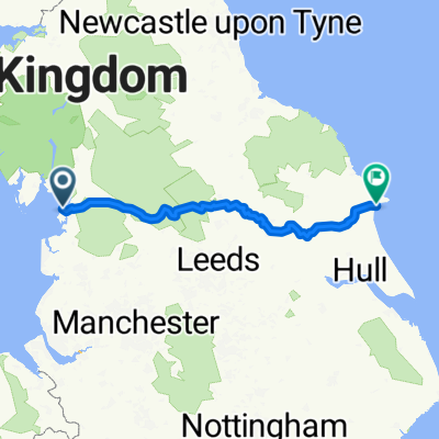 Morecambe to Bridlington via Grassington and York