L06KremsTulln
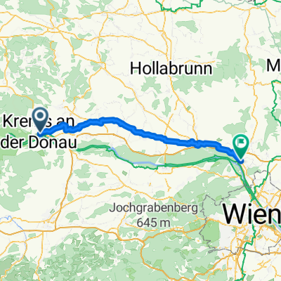
Una ruta en bici que comienza en Krems an der Donau, Baja Austria, Austria.
Visión General
Sobre esta ruta
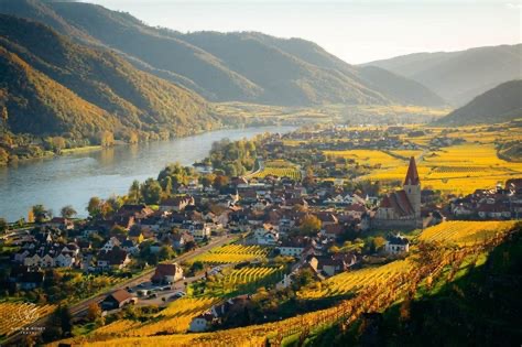
De ciudad medieval a ciudad de jardines y arte / La gira de hoy te lleva a lo largo de la ribera norte y sur del Danubio y fuera de la Wachau y su campo moldeado por la mano del hombre. Comienzas en Krems a lo largo del Danubio, un encantador centro de comercio y cultura, y pedaleas por el Camino ciclista del Danubio hacia Tulln, una ciudad del Danubio conocida por sus jardines y arte. Altenwörth y Zwentendorf están entre las ciudades que pasas antes de llegar a tu destino en la ribera sur del río. / AVISO IMPORTANTE: / Desde febrero de 2020 hasta finales de 2021, el Camino Ciclístico del Danubio se desvíará en el área de Höhe Ringstraße en Krems, debido a trabajos de tuberías necesarios. Además, el Treppelweg a lo largo del Danubio está en reformas hasta finales de junio. Por favor, sigue las señales de desvío en el área de la ciudad de Krems. / Debido a las obras de construcción, todo el tramo entre Krems y Tulln en la ribera norte estará cerrado desde abril de 2020 hasta diciembre de 2021. Pedimos amablemente a todos los ciclistas que viajan de Krems a Tulln o viceversa que utilicen el camino ciclista en la ribera sur. La desviación está señalizada. / Krems an der Donau – Altenworth (afluente Traisen) cruzamos el río hacia la orilla derecha - Zwentendorf an der Donau – Kleinschonbichl - Pischelsdorf - Langenschonbichl - Tulln ob Donavi (41 km, 20 m)
- -:--
- Duración
- 42,6 km
- Distancia
- 87 m
- Ascenso
- 108 m
- Descenso
- ---
- Velocidad Media
- 203 m
- Altitud máxima
Calidad de la ruta
Tipos de vía y superficies a lo largo de la ruta
Tipos de vía
Camino forestal
27,7 km
(65 %)
Carretera tranquila
6,4 km
(15 %)
Superficies
Pavimentado
40,9 km
(96 %)
Sin pavimentar
1,7 km
(4 %)
Asfalto
40,9 km
(96 %)
Sin asfaltar (sin definir)
1,7 km
(4 %)
Continuar con Bikemap
Usa, edita o descarga esta ruta en bici
¿Te gustaría recorrer L06KremsTulln o personalizarla para tu propio viaje? Esto es lo que puedes hacer con esta ruta de Bikemap:
Funciones gratuitas
- Guarda esta ruta como favorita o en una colección
- Copia y planifica tu propia versión de esta ruta
- Sincroniza tu ruta con Garmin o Wahoo
Funciones Premium
Prueba gratuita de 3 días o pago único. Más información sobre Bikemap Premium.
- Navega esta ruta en iOS y Android
- Exporta un archivo GPX / KML de esta ruta
- Crea tu impresión personalizada (pruébala gratis)
- Descarga esta ruta para la navegación sin conexión
Descubre más funciones Premium.
Consigue Bikemap PremiumDe nuestra comunidad
Krems an der Donau: Otras rutas populares que empiezan aquí
 Kleine Bergrunde
- Distancia
- 11,6 km
- Ascenso
- 221 m
- Descenso
- 221 m
- Ubicación
- Krems an der Donau, Baja Austria, Austria
 Krems - Wien 5. | Donauradweg
- Distancia
- 90,1 km
- Ascenso
- 240 m
- Descenso
- 293 m
- Ubicación
- Krems an der Donau, Baja Austria, Austria
 Krems-Fuglau
- Distancia
- 87,3 km
- Ascenso
- 961 m
- Descenso
- 961 m
- Ubicación
- Krems an der Donau, Baja Austria, Austria
 Krems to Spitz in Wachau
- Distancia
- 20,9 km
- Ascenso
- 249 m
- Descenso
- 218 m
- Ubicación
- Krems an der Donau, Baja Austria, Austria
 Wachau túra harmadik nap
- Distancia
- 42,1 km
- Ascenso
- 91 m
- Descenso
- 111 m
- Ubicación
- Krems an der Donau, Baja Austria, Austria
 Girolibero: Il Danubio e la Wachau wellness
- Distancia
- 380,1 km
- Ascenso
- 885 m
- Descenso
- 880 m
- Ubicación
- Krems an der Donau, Baja Austria, Austria
 Unbenannte Route
- Distancia
- 71,1 km
- Ascenso
- 179 m
- Descenso
- 206 m
- Ubicación
- Krems an der Donau, Baja Austria, Austria
 Krems - Weissenkirchen - Krems
- Distancia
- 34,6 km
- Ascenso
- 141 m
- Descenso
- 191 m
- Ubicación
- Krems an der Donau, Baja Austria, Austria
Ábrela en la app


