

CYCLING THE RHINE: Route 15A
Una ruta en bici que comienza en Gernsheim, Hessen, Alemania.
Visión General
Sobre esta ruta
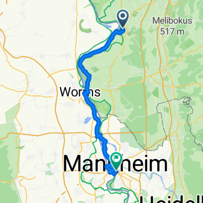
Estación de tren de Gernsheim a estación de tren de Mannheim, siguiendo el río Rin.
- -:--
- Duración
- 48,8 km
- Distancia
- 89 m
- Ascenso
- 79 m
- Descenso
- ---
- Velocidad Media
- ---
- Altitud máxima
Calidad de la ruta
Tipos de vía y superficies a lo largo de la ruta
Tipos de vía
Camino forestal
20,5 km
(42 %)
Ruta
8,3 km
(17 %)
Superficies
Pavimentado
30,7 km
(63 %)
Sin pavimentar
9,3 km
(19 %)
Asfalto
22,9 km
(47 %)
Hormigón
6,8 km
(14 %)
Destacados de la ruta
Puntos de interés a lo largo de la ruta
Punto de interés después de 1,5 km
If you prefer, follow this road as it curves left, then right to the Rhine. Turn left at the riverside, along the cyclepath.
Punto de interés después de 2,1 km
At this point, the previous described route (Route 14A) deviated from the Rhine Route to terminate at Gernsheim railway station. To continue along the Rhine-side route, continue with the Rhine on your right hand side and join Route 15A at the next marked point on this map.
Punto de interés después de 2,3 km
Rejoin the Rhine Route at this point, from Route 14A.
Alojamiento después de 21,1 km
Camp Site: I have used this campsite in the past and found the facilities to be excellent. Even after it had been recently flooded, I found a suitable place to camp.
Alojamiento después de 22,4 km
YOUTH HOSTEL: DJH Worms Dechaneigasse 1 67547 Worms I have stayed at this hostel and can recommend both the facilities and the cuisine.
Alojamiento después de 22,7 km
Friends of Nature Hostel, Worms
Punto de interés después de 32,5 km
Bridge support (tower), with steps on the inside.
Punto de interés después de 33,4 km
Bridge support (tower) with steps down on the inside.
Punto de interés después de 37,3 km
Alternative route, when Sandhofer ferry is not operating, joins here.
Punto de interés después de 44,8 km
At this point, instead of turning Left, you can carry straight onwards, swinging left to take the bi-directional cycle path along the left hand side of the bridge. When you reach the other side, take the bike offramp, then follow the signs to Jugendherberge (Youth Hostel), until you join the described route along the bike paths or near the Rhine.
Punto de interés después de 46,9 km
Rejoin the described Route here, if you took the LHS bike path across the bridge.
Alojamiento después de 47,2 km
YOUTH HOSTEL: DJH Mannheim Rheinpromenade 21 68163 Mannheim
Punto de interés después de 47,8 km
At this point, the route deviates from the Rhine Route, to terminate at Mannheim railway station. Continue along the riverside track (right fork) to continue along the Rhine Route.
Continuar con Bikemap
Usa, edita o descarga esta ruta en bici
¿Te gustaría recorrer CYCLING THE RHINE: Route 15A o personalizarla para tu propio viaje? Esto es lo que puedes hacer con esta ruta de Bikemap:
Funciones gratuitas
- Guarda esta ruta como favorita o en una colección
- Copia y planifica tu propia versión de esta ruta
- Sincroniza tu ruta con Garmin o Wahoo
Funciones Premium
Prueba gratuita de 3 días o pago único. Más información sobre Bikemap Premium.
- Navega esta ruta en iOS y Android
- Exporta un archivo GPX / KML de esta ruta
- Crea tu impresión personalizada (pruébala gratis)
- Descarga esta ruta para la navegación sin conexión
Descubre más funciones Premium.
Consigue Bikemap PremiumDe nuestra comunidad
Gernsheim: Otras rutas populares que empiezan aquí
 Rhein-Radweg
- Distancia
- 22,2 km
- Ascenso
- 25 m
- Descenso
- 26 m
- Ubicación
- Gernsheim, Hessen, Alemania
 Vatertagsrunde
- Distancia
- 40,9 km
- Ascenso
- 145 m
- Descenso
- 144 m
- Ubicación
- Gernsheim, Hessen, Alemania
 Gernsheim-Worms
- Distancia
- 43 km
- Ascenso
- 48 m
- Descenso
- 46 m
- Ubicación
- Gernsheim, Hessen, Alemania
 CYCLING THE RHINE: Route 15A
- Distancia
- 48,9 km
- Ascenso
- 95 m
- Descenso
- 85 m
- Ubicación
- Gernsheim, Hessen, Alemania
 Gernsheim - Kühkopf
- Distancia
- 23,5 km
- Ascenso
- 57 m
- Descenso
- 51 m
- Ubicación
- Gernsheim, Hessen, Alemania
 Kühkopfrunde 2019
- Distancia
- 59,9 km
- Ascenso
- 67 m
- Descenso
- 65 m
- Ubicación
- Gernsheim, Hessen, Alemania
 Gernsheim - Odenwald - 80km
- Distancia
- 81 km
- Ascenso
- 759 m
- Descenso
- 762 m
- Ubicación
- Gernsheim, Hessen, Alemania
 CYCLING THE RHINE: Route 15A
- Distancia
- 48,8 km
- Ascenso
- 89 m
- Descenso
- 79 m
- Ubicación
- Gernsheim, Hessen, Alemania
Ábrela en la app