
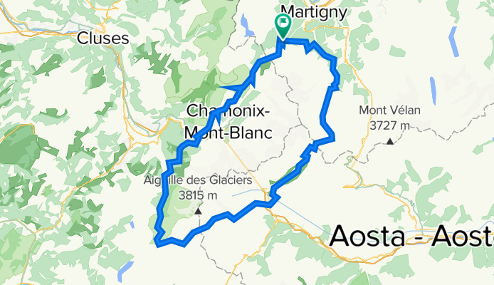
Hiking 120 Miles Alone on the Tour Du Mont Blanc Loop
Una ruta en bici que comienza en Martigny-Combe, Valais, Suiza.
Visión General
Sobre esta ruta
El Tour du Mont Blanc es un circuito de 120 millas que rodea el macizo del Mont Blanc y atraviesa los Alpes suizos, franceses e italianos. Cada sección de cada país tiene su propia personalidad. El sendero está bien mantenido y está salpicado de coloridas marcas 'TMB'. Encontrarás muchas otras personas en este sendero, todos caminando por diferentes razones. Normalmente es imposible saber cuánto tiempo lleva alguien caminando porque el circuito es un lazo sin un punto de inicio o fin técnico. Encontrarás excursionistas de larga distancia con grandes mochilas haciendo todo el circuito, senderistas de un día, turistas de góndola, corredores de trail, ciclistas de montaña, familias con perros y locales paseando por la mañana. Pasarás por pequeños pueblos escondidos en las montañas y grandes ciudades bulliciosas llenas de turistas. El sendero está salpicado de Refugios y campamentos donde puedes comer, beber y dormir. El sendero es seguro, lleno de gente dispuesta a ayudarte si es necesario, y muy desarrollado, por lo que cualquiera en buena salud y siguiendo su propio ritmo puede completar el circuito completo. Recomiendo el Tour du Mont Blanc para cualquiera que intente su primera caminata de más de 100 millas debido a su belleza, dificultad moderada y bajo riesgo. Aunque es un sendero muy popular y muy transitado en Europa, aún puedes encontrar momentos tranquilos de aislamiento entre pueblos y en los pasos de montaña alejados de carreteras o góndolas.
- -:--
- Duración
- 165,3 km
- Distancia
- 12.832 m
- Ascenso
- 12.837 m
- Descenso
- ---
- Velocidad Media
- 2663 m
- Altitud máxima

Continuar con Bikemap
Usa, edita o descarga esta ruta en bici
¿Te gustaría recorrer Hiking 120 Miles Alone on the Tour Du Mont Blanc Loop o personalizarla para tu propio viaje? Esto es lo que puedes hacer con esta ruta de Bikemap:
Funciones gratuitas
- Guarda esta ruta como favorita o en una colección
- Copia y planifica tu propia versión de esta ruta
- Divídelo en etapas para crear una excursión de varios días
- Sincroniza tu ruta con Garmin o Wahoo
Funciones Premium
Prueba gratuita de 3 días o pago único. Más información sobre Bikemap Premium.
- Navega esta ruta en iOS y Android
- Exporta un archivo GPX / KML de esta ruta
- Crea tu impresión personalizada (pruébala gratis)
- Descarga esta ruta para la navegación sin conexión
Descubre más funciones Premium.
Consigue Bikemap PremiumDe nuestra comunidad
Martigny-Combe: Otras rutas populares que empiezan aquí
 MontBlancTour5Tag
- Distancia
- 14 km
- Ascenso
- 1107 m
- Descenso
- 935 m
- Ubicación
- Martigny-Combe, Valais, Suiza
 Route de la Forclaz, Martigny-Croix nach Chemin du Glacier de Taconnaz, Chamonix-Mont-Blanc
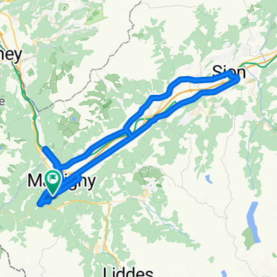
- Distancia
- 35,6 km
- Ascenso
- 658 m
- Descenso
- 964 m
- Ubicación
- Martigny-Combe, Valais, Suiza
 La Chatelard-Lac de Emosson
- Distancia
- 18,3 km
- Ascenso
- 1556 m
- Descenso
- 838 m
- Ubicación
- Martigny-Combe, Valais, Suiza
 Trevor Base Route
- Distancia
- 93,3 km
- Ascenso
- 715 m
- Descenso
- 715 m
- Ubicación
- Martigny-Combe, Valais, Suiza
 Hiking 120 Miles Alone on the Tour Du Mont Blanc Loop
- Distancia
- 165,3 km
- Ascenso
- 12.832 m
- Descenso
- 12.837 m
- Ubicación
- Martigny-Combe, Valais, Suiza
 Trevor - Champex lac loop
- Distancia
- 42,5 km
- Ascenso
- 1099 m
- Descenso
- 1099 m
- Ubicación
- Martigny-Combe, Valais, Suiza
 2017 ALPS Etapa 7 - Le Grand St Bernanrd
- Distancia
- 108,8 km
- Ascenso
- 2888 m
- Descenso
- 2896 m
- Ubicación
- Martigny-Combe, Valais, Suiza
 VTT MONT BLANC Vllorcine Albertville
- Distancia
- 432,8 km
- Ascenso
- 8172 m
- Descenso
- 8462 m
- Ubicación
- Martigny-Combe, Valais, Suiza
Ábrela en la app