

DAY SIX Caen - Ouistreham
Una ruta en bici que comienza en Caen, Normandía, Francia.
Visión General
Sobre esta ruta
Day Six
Gare de Caen - Hotel L'Ecailler, Ouistreham
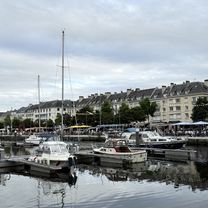
An easy 15km bike ride along an established voie verte or greenway route links Caen town centre to the ferry port in Ouistreham, providing easy access to Portsmouth, England. The voie verte runs alongside the Canal de Caen à la Mer, which in turn runs parallel to the River Orne. The canal is one of France's best established, having been started in 1837, with the thoroughfare opening to boats 20 years later. The canal has two locks, the one near the port at Ouistreham is large enough to allow ships of more than 200m through. There are many key sites to see along the route and near Ouistreham, of the World War II, D-Day landings. The Pegasus Bridge, which crosses the canal near Bénouville is another significant site in World War Two history, having been named after an Allied operation in the opening hours of the Normsndy landings. Britain's 6th Airborne Division was ordered to take and hold the bridge to limit the success of German efforts to make inroads into Allied-held territory. Pegasus was on the shoulder emblem of that division. The bridge seen today, however, is not the original, but a reconstruction; the original is now in the Mémorial Pegasus Musée nearby. Sword Beach, a little west of Ouistreham, is also worth exploring. It was one of three British-Canadian landing areas. The beach represents the eastern flank of the Allied amphibious attack in Normandy. There is so many sites to see it would take several days to do them all justice. Brittany Ferries operates the service to / from Portsmouth and there are various travel times depending on the date and season. There is a campsite near the ferry port itself which is open to touring tents in the summer months (July - October). Camping Riva Bella 1 Rue de la Haie Breton, 14150 Ouistreham, FRANCE TEL: +33 2 31 97 12 66 Various hotels in Ouistreham provide another option for those wishing to stay overnight or for a few days. Booking.com
- 1 h 1 min
- Duración
- 15,3 km
- Distancia
- 69 m
- Ascenso
- 75 m
- Descenso
- 15,1 km/h
- Velocidad Media
- 10 m
- Altitud máxima

Calidad de la ruta
Tipos de vía y superficies a lo largo de la ruta
Tipos de vía
Ruta
11,7 km
(76 %)
Zona peatonal
2 km
(13 %)
Superficies
Pavimentado
14,3 km
(93 %)
Sin pavimentar
1,1 km
(7 %)
Asfalto
14,1 km
(92 %)
Grava
1,1 km
(7 %)
Hormigón
0,2 km
(1 %)
Continuar con Bikemap
Usa, edita o descarga esta ruta en bici
¿Te gustaría recorrer DAY SIX Caen - Ouistreham o personalizarla para tu propio viaje? Esto es lo que puedes hacer con esta ruta de Bikemap:
Funciones gratuitas
- Guarda esta ruta como favorita o en una colección
- Copia y planifica tu propia versión de esta ruta
- Sincroniza tu ruta con Garmin o Wahoo
Funciones Premium
Prueba gratuita de 3 días o pago único. Más información sobre Bikemap Premium.
- Navega esta ruta en iOS y Android
- Exporta un archivo GPX / KML de esta ruta
- Crea tu impresión personalizada (pruébala gratis)
- Descarga esta ruta para la navegación sin conexión
Descubre más funciones Premium.
Consigue Bikemap PremiumDe nuestra comunidad
Caen: Otras rutas populares que empiezan aquí
 préparation ballade AF3v
- Distancia
- 56,3 km
- Ascenso
- 156 m
- Descenso
- 145 m
- Ubicación
- Caen, Normandía, Francia
 Caen-Cabourg
- Distancia
- 28,8 km
- Ascenso
- 34 m
- Descenso
- 45 m
- Ubicación
- Caen, Normandía, Francia
 Caen - Lion-sur-Mer
- Distancia
- 22,6 km
- Ascenso
- 53 m
- Descenso
- 59 m
- Ubicación
- Caen, Normandía, Francia
 caen mont pinson
- Distancia
- 83,9 km
- Ascenso
- 494 m
- Descenso
- 496 m
- Ubicación
- Caen, Normandía, Francia
 Caen Merville
- Distancia
- 17,5 km
- Ascenso
- 32 m
- Descenso
- 35 m
- Ubicación
- Caen, Normandía, Francia
 Caen - Mortain
- Distancia
- 84,1 km
- Ascenso
- 798 m
- Descenso
- 566 m
- Ubicación
- Caen, Normandía, Francia
 Caen à D 514, Ranville
- Distancia
- 14,8 km
- Ascenso
- 46 m
- Descenso
- 63 m
- Ubicación
- Caen, Normandía, Francia
 B/F Caen - Le Vey VV Suisse Normandie
- Distancia
- 38,8 km
- Ascenso
- 276 m
- Descenso
- 257 m
- Ubicación
- Caen, Normandía, Francia
Ábrela en la app