

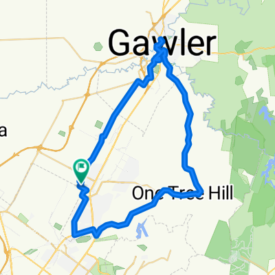
Elizabeth East to Hilton South Australia
Una ruta en bici que comienza en Elizabeth, State of South Australia, Australia.
Visión General
Sobre esta ruta
Uso esto como mi ruta de viaje. Podría usar Salisbury Hwy, pero no hay una conexión "segura" con Churchill Rd North desde la intersección de Port Wakefield Rd. Hay muchos camiones semirremolque aquí.
La parte de la ruta que corre paralela al Aeropuerto de Parafield es un camino compartido. No está iluminado por la noche y los árboles están invadiendo. La superficie está asfaltada, sin embargo, en el extremo sur cerca del Intercambio Mawson Lakes hay grava y un puente de listones de madera con marco de acero para cruzar.
Los semáforos en la esquina de Port Rd y James Congdon Drive son amigables con las bicicletas con botones y áreas de refugio seguras.
La ruta puede continuar hacia el aeropuerto de Adelaide, West Beach y girar a la izquierda en Tapleys Hill Rd hacia Glenelg o hacia la costa y luego a la derecha hacia Semaphore y otros suburbios.
- -:--
- Duración
- 30,5 km
- Distancia
- 48 m
- Ascenso
- 91 m
- Descenso
- ---
- Velocidad Media
- ---
- Altitud máxima
Continuar con Bikemap
Usa, edita o descarga esta ruta en bici
¿Te gustaría recorrer Elizabeth East to Hilton South Australia o personalizarla para tu propio viaje? Esto es lo que puedes hacer con esta ruta de Bikemap:
Funciones gratuitas
- Guarda esta ruta como favorita o en una colección
- Copia y planifica tu propia versión de esta ruta
- Sincroniza tu ruta con Garmin o Wahoo
Funciones Premium
Prueba gratuita de 3 días o pago único. Más información sobre Bikemap Premium.
- Navega esta ruta en iOS y Android
- Exporta un archivo GPX / KML de esta ruta
- Crea tu impresión personalizada (pruébala gratis)
- Descarga esta ruta para la navegación sin conexión
Descubre más funciones Premium.
Consigue Bikemap PremiumDe nuestra comunidad
Elizabeth: Otras rutas populares que empiezan aquí
 trip...
- Distancia
- 11,6 km
- Ascenso
- 25 m
- Descenso
- 56 m
- Ubicación
- Elizabeth, State of South Australia, Australia
 Star Cycles Inglewood-COP-Kersbrook
- Distancia
- 64 km
- Ascenso
- 717 m
- Descenso
- 717 m
- Ubicación
- Elizabeth, State of South Australia, Australia
 Star Cycles - Sandy Creek - hillier rd
- Distancia
- 59,8 km
- Ascenso
- 196 m
- Descenso
- 196 m
- Ubicación
- Elizabeth, State of South Australia, Australia
 Yorktown Road 32, Elizabeth East to McCormack Crescent 50, Salisbury North
- Distancia
- 20,9 km
- Ascenso
- 255 m
- Descenso
- 285 m
- Ubicación
- Elizabeth, State of South Australia, Australia
 Elizabeth - Nuriootpa
- Distancia
- 134,8 km
- Ascenso
- 960 m
- Descenso
- 722 m
- Ubicación
- Elizabeth, State of South Australia, Australia
 One Tree Hill Scenic route Gawler
- Distancia
- 57,1 km
- Ascenso
- 330 m
- Descenso
- 330 m
- Ubicación
- Elizabeth, State of South Australia, Australia
 1/1 ride
- Distancia
- 47,6 km
- Ascenso
- 1467 m
- Descenso
- 1465 m
- Ubicación
- Elizabeth, State of South Australia, Australia
 Elizabeth to Keswick (BikeSA) via Torrens River Trail
- Distancia
- 42,3 km
- Ascenso
- 275 m
- Descenso
- 327 m
- Ubicación
- Elizabeth, State of South Australia, Australia
Ábrela en la app