
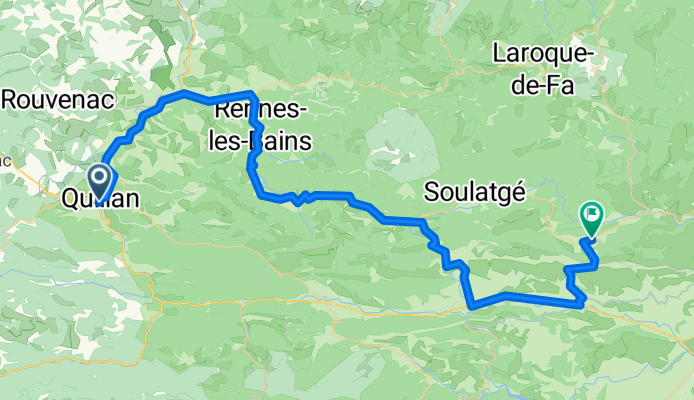
Ride Day 17—27 Sept 2005—11500 Quillan to 11350 Cucugnan
Una ruta en bici que comienza en Quillan, Occitanie, Francia.
Visión General
Sobre esta ruta
Con la excepción de dos carreteras principales (D118 y D117), el paseo de hoy fue realmente excepcional.
La D14 ascendió por una zona hermosa que se volvió algo árida cerca del Pic de Bugarach, que es una vista impresionante desde cualquier ángulo. El Pic de Bugarach tiene 1230 m de altura y lo pasamos por el Col du Linas a 680 m. Este año, íbamos de oeste a este. Hace cuatro años, viajamos por esta carretera de este a oeste.
La D10/D17 nos llevó a través de una hermosa garganta con una carretera estrecha tallada en los lados. Carretera increíble y vistas maravillosas. Mientras íbamos por esta carretera, pasamos las próximas horas en el departamento de Pirineos Orientales antes de regresar a Aude por la D19/D123. Esta última carretera de Maury a Cucugnan fue una bonita subida sobre un valle rodeado de montañas. Esta subida nos llevó al Grau de Maury a 432 m, donde hay una carretera que sube más hasta el Castillo de Quéribus. Desde el Grau de Maury, descendimos directamente a Cucugnan, que está situado en una pequeña colina dentro de otro valle enorme rodeado de montañas. Al igual que el valle de Maury, hay muchas viñas.
Antecedentes:
Mi esposa y yo hemos estado haciendo recorridos auto-suficientes en Europa Occidental (mayormente en Francia) desde 1993. Esta serie de paseos cubre nuestra ruta de 2 meses en 2005 por partes de Francia. Nuestro punto de inicio y fin está cerca de Chaduri (al sur de Angoulême), donde nuestros amigos tienen una granja con Gîtes y Chambres d'Hôtes.
Montamos nuestras bicicletas de turismo Dawes compradas en 1993, cargadas con neumáticos 700Cx32. Todo nuestro recorrido fue por carreteras pavimentadas, mayormente con muy poco tráfico.
Si tiene alguna pregunta, no dude en enviarme un correo electrónico a jeffkadet@netdiving.com
Jeff
- -:--
- Duración
- 66,6 km
- Distancia
- 778 m
- Ascenso
- 790 m
- Descenso
- ---
- Velocidad Media
- ---
- Altitud máxima

Continuar con Bikemap
Usa, edita o descarga esta ruta en bici
¿Te gustaría recorrer Ride Day 17—27 Sept 2005—11500 Quillan to 11350 Cucugnan o personalizarla para tu propio viaje? Esto es lo que puedes hacer con esta ruta de Bikemap:
Funciones gratuitas
- Guarda esta ruta como favorita o en una colección
- Copia y planifica tu propia versión de esta ruta
- Sincroniza tu ruta con Garmin o Wahoo
Funciones Premium
Prueba gratuita de 3 días o pago único. Más información sobre Bikemap Premium.
- Navega esta ruta en iOS y Android
- Exporta un archivo GPX / KML de esta ruta
- Crea tu impresión personalizada (pruébala gratis)
- Descarga esta ruta para la navegación sin conexión
Descubre más funciones Premium.
Consigue Bikemap PremiumDe nuestra comunidad
Quillan: Otras rutas populares que empiezan aquí
 Belvédère du Diable
- Distancia
- 7 km
- Ascenso
- 442 m
- Descenso
- 441 m
- Ubicación
- Quillan, Occitanie, Francia
 Quillan - Grandvalira Sector Carrillo
- Distancia
- 191,1 km
- Ascenso
- 4499 m
- Descenso
- 2756 m
- Ubicación
- Quillan, Occitanie, Francia
 2009 Entre-deux-mers - 2
- Distancia
- 259,7 km
- Ascenso
- 79 m
- Descenso
- 328 m
- Ubicación
- Quillan, Occitanie, Francia
 AAA Pyrenäen 2
- Distancia
- 94 km
- Ascenso
- 2426 m
- Descenso
- 2735 m
- Ubicación
- Quillan, Occitanie, Francia
 VTT Pyrénées - circuit n°22
- Distancia
- 29,8 km
- Ascenso
- 584 m
- Descenso
- 584 m
- Ubicación
- Quillan, Occitanie, Francia
 Col de Jau
- Distancia
- 100,8 km
- Ascenso
- 2279 m
- Descenso
- 2279 m
- Ubicación
- Quillan, Occitanie, Francia
 Ride Day 17—27 Sept 2005—11500 Quillan to 11350 Cucugnan
- Distancia
- 66,6 km
- Ascenso
- 778 m
- Descenso
- 790 m
- Ubicación
- Quillan, Occitanie, Francia
 Ride Day 16—26 Sept 2005—11500 Quillan - Circle
- Distancia
- 60,1 km
- Ascenso
- 747 m
- Descenso
- 748 m
- Ubicación
- Quillan, Occitanie, Francia
Ábrela en la app