

Ride Day 22—3 Oct 2005—34220 St-Pons-de-Thomières to 81320 Murat-sur-Vèbre
Una ruta en bici que comienza en Saint-Pons-de-Thomières, Occitanie, Francia.
Visión General
Sobre esta ruta
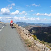
<span style="font-size: 12pt; font-family: Arial;">Today’s area and roads were outstanding.<span> </span>Only D907 had more traffic than we would have liked.<span> </span>Also, we passed from the Hérault Department into the Tarn Department.<span> </span>This also meant that we’d left the Languedoc-Roussillon Region and entered the Midi-Pyrénées Region.</span>
<span style="font-size: 12pt; font-family: Arial;">Starting from St Pons at 320 M, we immediately climbed to 941 M at the first col and from then until arriving in Murat, we descended and climbed within a 200 or so meter band until finishing at 840 M in Murat.</span>
<span style="font-size: 12pt; font-family: Arial;">Just before reaching the first col, we stopped and were just about frozen by the gale force cold wind.<span> </span>After putting on our rain pants, jerseys and gloves, we felt much better.<span> </span>Happily, we had no rain until the last four miles or so along D162Cand D162 into Murat.</span>
Background:<br /><br /><br />My wife and I have been doing self-supported tours in Western Europe (a majority in France) since 1993. This series of rides covers our 2005 2 month route through parts of France. Our beginning and ending point is near Chaduri (south of Angoulême) where our friends have a farm with Gites and Chambres d'Hotes.<br /><br /><br />We rode our Dawes touring bicycles purchased in 1993 heavily loaded with 700Cx32 tires. All of our riding was on paved roads, mostly with very little traffic.<br /><br /><br />If any questions, feel free to email me at jeffkadet@netdiving.com<br /><br /><br />Jeff
- -:--
- Duración
- 40,5 km
- Distancia
- 1041 m
- Ascenso
- 511 m
- Descenso
- ---
- Velocidad Media
- ---
- Altitud máxima

Calidad de la ruta
Tipos de vía y superficies a lo largo de la ruta
Tipos de vía
Carretera
20,1 km
(50 %)
Carretera concurrida
18,6 km
(46 %)
Superficies
Pavimentado
1 km
(2 %)
Asfalto
1 km
(2 %)
Sin definir
39,5 km
(98 %)
Continuar con Bikemap
Usa, edita o descarga esta ruta en bici
¿Te gustaría recorrer Ride Day 22—3 Oct 2005—34220 St-Pons-de-Thomières to 81320 Murat-sur-Vèbre o personalizarla para tu propio viaje? Esto es lo que puedes hacer con esta ruta de Bikemap:
Funciones gratuitas
- Guarda esta ruta como favorita o en una colección
- Copia y planifica tu propia versión de esta ruta
- Sincroniza tu ruta con Garmin o Wahoo
Funciones Premium
Prueba gratuita de 3 días o pago único. Más información sobre Bikemap Premium.
- Navega esta ruta en iOS y Android
- Exporta un archivo GPX / KML de esta ruta
- Crea tu impresión personalizada (pruébala gratis)
- Descarga esta ruta para la navegación sin conexión
Descubre más funciones Premium.
Consigue Bikemap PremiumDe nuestra comunidad
Saint-Pons-de-Thomières: Otras rutas populares que empiezan aquí
 2019 Mazamet-Herepian
- Distancia
- 13,2 km
- Ascenso
- 177 m
- Descenso
- 63 m
- Ubicación
- Saint-Pons-de-Thomières, Occitanie, Francia
 Etape 16– De Lacan à Minerve - Itinéraire Sud
- Distancia
- 18,2 km
- Ascenso
- 501 m
- Descenso
- 790 m
- Ubicación
- Saint-Pons-de-Thomières, Occitanie, Francia
 Ride Day 22—3 Oct 2005—34220 St-Pons-de-Thomières to 81320 Murat-sur-Vèbre
- Distancia
- 40,5 km
- Ascenso
- 1041 m
- Descenso
- 511 m
- Ubicación
- Saint-Pons-de-Thomières, Occitanie, Francia
 Etape 15 – De Rodomouls à Lacan - Itinéraire Sud
- Distancia
- 16,9 km
- Ascenso
- 402 m
- Descenso
- 482 m
- Ubicación
- Saint-Pons-de-Thomières, Occitanie, Francia
 Leg 2 Day 4 kurz
- Distancia
- 113,1 km
- Ascenso
- 869 m
- Descenso
- 1053 m
- Ubicación
- Saint-Pons-de-Thomières, Occitanie, Francia
 Saint-Pons-de-Thomières - Lamalou-les-Bains
- Distancia
- 72,9 km
- Ascenso
- 1178 m
- Descenso
- 1284 m
- Ubicación
- Saint-Pons-de-Thomières, Occitanie, Francia
 Leg 2 Day 4
- Distancia
- 121,8 km
- Ascenso
- 966 m
- Descenso
- 1150 m
- Ubicación
- Saint-Pons-de-Thomières, Occitanie, Francia
 2015_FR_80 km_1800 hm
- Distancia
- 81,3 km
- Ascenso
- 1679 m
- Descenso
- 1791 m
- Ubicación
- Saint-Pons-de-Thomières, Occitanie, Francia
Ábrela en la app