

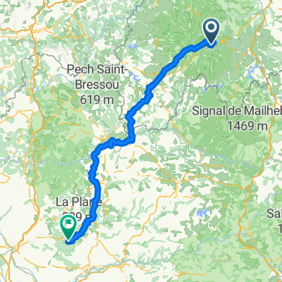
Ride Day 35—16 Oct 2005—15400 Le Claux to 19220 St-Julien-aux-Bois
Una ruta en bici que comienza en Murat, Auvernia-Ródano-Alpes, Francia.
Visión General
Sobre esta ruta
Today was an outstanding ride that almost didn’t happen. We woke up to a terribly sky and rain. After hearing the opinions on the weather from the party of three (tomorrow will be better) and from the proprietor (maybe…maybe this afternoon things will get better), my wife decided that the sky looked encouraging despite the continuing light rain and we set out in our rain gear a bit before 10:00 AM.
We could not have been more fortunate. Although we didn’t actually see the sun until maybe 3:00 PM, the light rain stopped and we climbed through the various cols pretty quickly…relatively speaking, that is.
This year we did the reverse of our 2004 ride when we went through Salers and the Puy Mary from west to east. While the views would be spectacular were there blue skies and bright sunshine, the mist and clean air from all the recent rain gave us some very different and wonderful views.
@font-face { font-family: "Times New Roman"; }@font-face { font-family: "Arial"; }p.MsoNormal, li.MsoNormal, div.MsoNormal { margin: 0in 0in 0.0001pt; font-size: 12pt; font-family: "Times New Roman"; }table.MsoNormalTable { font-size: 10pt; font-family: "Times New Roman"; }div.Section1 { page: Section1; } As most of today’s ride was downhill, our number of meters climbed wasn’t much today. However, those 830 M we did climb felt like a lot more. During the ride, we passed through the Col de Serre (1335 M), the Col d’Eylac (about 1450 M), the Pas de Peyrol (1588 M), and the Col de Neronne (1242 M).
Background:My wife and I have been doing self-supported tours in Western Europe (a majority in France) since 1993. This series of rides covers our 2005 2 month route through parts of France. Our beginning and ending point is near Chaduri (south of Angoulême) where our friends have a farm with Gites and Chambres d'Hotes.We rode our Dawes touring bicycles purchased in 1993 heavily loaded with 700Cx32 tires. All of our riding was on paved roads, mostly with very little traffic.If any questions, feel free to email me at jeffkadet@netdiving.comJeff
- -:--
- Duración
- 65,4 km
- Distancia
- 701 m
- Ascenso
- 1161 m
- Descenso
- ---
- Velocidad Media
- ---
- Altitud máxima

Continuar con Bikemap
Usa, edita o descarga esta ruta en bici
¿Te gustaría recorrer Ride Day 35—16 Oct 2005—15400 Le Claux to 19220 St-Julien-aux-Bois o personalizarla para tu propio viaje? Esto es lo que puedes hacer con esta ruta de Bikemap:
Funciones gratuitas
- Guarda esta ruta como favorita o en una colección
- Copia y planifica tu propia versión de esta ruta
- Sincroniza tu ruta con Garmin o Wahoo
Funciones Premium
Prueba gratuita de 3 días o pago único. Más información sobre Bikemap Premium.
- Navega esta ruta en iOS y Android
- Exporta un archivo GPX / KML de esta ruta
- Crea tu impresión personalizada (pruébala gratis)
- Descarga esta ruta para la navegación sin conexión
Descubre más funciones Premium.
Consigue Bikemap PremiumDe nuestra comunidad
Murat: Otras rutas populares que empiezan aquí
 Ride Day 35—16 Oct 2005—15400 Le Claux to 19220 St-Julien-aux-Bois
- Distancia
- 65,4 km
- Ascenso
- 701 m
- Descenso
- 1161 m
- Ubicación
- Murat, Auvernia-Ródano-Alpes, Francia
 BTT 2020 - Secteur 2
- Distancia
- 211,9 km
- Ascenso
- 3652 m
- Descenso
- 4577 m
- Ubicación
- Murat, Auvernia-Ródano-Alpes, Francia
 Murat to Pleaux
- Distancia
- 81,8 km
- Ascenso
- 1230 m
- Descenso
- 1487 m
- Ubicación
- Murat, Auvernia-Ródano-Alpes, Francia
 Massif Central 2009 - Tour 1 - Pässe des Cantal
- Distancia
- 128,1 km
- Ascenso
- 2865 m
- Descenso
- 2758 m
- Ubicación
- Murat, Auvernia-Ródano-Alpes, Francia
 Volcan Ouest - 2481-Utagawa
- Distancia
- 15,8 km
- Ascenso
- 632 m
- Descenso
- 633 m
- Ubicación
- Murat, Auvernia-Ródano-Alpes, Francia
 Murat 1 (zuiden)
- Distancia
- 108,1 km
- Ascenso
- 1497 m
- Descenso
- 1497 m
- Ubicación
- Murat, Auvernia-Ródano-Alpes, Francia
 C: Lavigerie (pas de peyrol) - Saint-Vincent-de-Cosse, 3. Etappe: Genf - Bordeaux
- Distancia
- 189,6 km
- Ascenso
- 892 m
- Descenso
- 1947 m
- Ubicación
- Murat, Auvernia-Ródano-Alpes, Francia
 France2023 E14
- Distancia
- 71,2 km
- Ascenso
- 1421 m
- Descenso
- 1644 m
- Ubicación
- Murat, Auvernia-Ródano-Alpes, Francia
Ábrela en la app