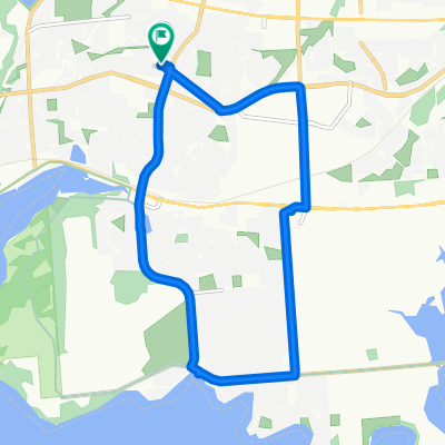
Burnthills - Battersea - Sydenham - Harrowsmith
- 104,6 km
- 440 m
- 407 m
- Kingston, Ontario, Canadá
Una ruta en bici que comienza en Kingston, Ontario, Canadá.
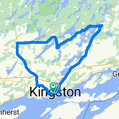
Visión General
creado hace 14 años
Destacados de la ruta
North Kingston route approximate. Bikemap.net is a nightmare to make accurate in this area.
Approximate location: One of the original milestones is here, and a sign notes the road opened in 1837, as a toll route.
Babcock Mill. http://www.loyalisttownship.ca/discover-babcockmill "100 Bridge Street, Odessa Built in 1856 this historic mill is a must see when visiting Odessa. The mill combined woolen factory, grist, planning and saw milling operations. It has been restored as a fully operational water-powered mill and park site. "
"Babcock Hall"? an outsized residence, as big as a 4-room school. Two-storeys, red brick, in good repair and for sale.
Traffic circle or "roundabout". Rare in these parts and fairly new.
Approximately here: a well-dented racing stock car is parked in the grass. This photographed well, I have seen the b&w negative and it is worth printing.
My destination: an appointment with my nose specialist doctor, who moved his practice to Napanee.
Approximate location of Avril Lavigne's pizza shop. My lunch stop. Pizza sub-standard and inexpensive. Link [see first item]: http://www.niemegker.de/napanee-ontario.htm
North wind continued with steady rain and approximately 7C.
Cold rain continued. Fresh, finely crushed limestone made a slurpy grey slurry, which soon covered my bike and shoe covers.
Riding in mud, with a cold, steady rain, received cell-call from Amnesty International. Rather than have them call back, I asked them to continue taking my monthly money and not call back.
West end of Switzerville Road: narrow, tree-lined, gravel. Almost like a rail-trail. Interesting old farms in various states of dilapidation.
"Downtown Switzerville" Intersting old building: Link: http://www.loyalisttownship.ca/discover-profileswitzerville "This community was named after Peter Switzer in 1790. In 1820 a simple frame meeting house was built for 40 local Methodists and this building was used as the first Canada conference of Methodists in 1828."
Paved shoulder here, nice and wide.
Location from [fuzzy] memory: "Rosies"s Rodeo and Roast". A ten-foot long, six-feet high pink concrete pig is out front, near the road. Apparently the site of an annual Harley-Davidson riders' gathering. Warning: Pictures on the linked page contain tattoo content. http://www.chaeron.com/sightings/rosies99_memories.htm
Paved road. Wide, with paved shoulder, a bit boring.
Road narrows and becomes more interesting.
Road very narrow, tarred gravel.
Flat area, with mix of rural residential, farms, and Sopranos-esque waste-disposal businesses.
Encountered first frozen precipitation of Fall 2011. THe soiund in the woods was as if lentils were falling from the sky.
Boring, paved, wide road. Paved shoulder A-OK.
K&P rail trail crosses road here.
K&P Trail. Excellent. Smooth gravel.
K&P Trail. Location approximate.
Newest K&P bridge, opened August 2011.
K&P Trail Eastern [and southern] trailhead.
Urban worm-hole, 100 metres of sidewalk.
Urban wormhole #2: foot path between subdivisions.
Urban wormhole #3: city footpath between streets.
Continuar con Bikemap
¿Te gustaría recorrer Napanee and Back. Oct. 26, 2011. o personalizarla para tu propio viaje? Esto es lo que puedes hacer con esta ruta de Bikemap:
Prueba gratuita de 3 días o pago único. Más información sobre Bikemap Premium.
Descubre más funciones Premium.
Consigue Bikemap PremiumDe nuestra comunidad
Ábrela en la app