

Mallorca - Alcudia
Alcudia - Puig Mayor (kongeetapen)
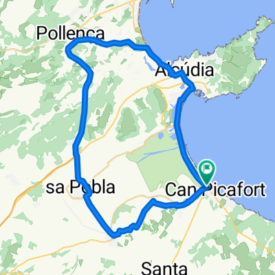
Una ruta en bici que comienza en Port d'Alcúdia, Comunidad Autónoma de las Islas Baleares, España.
Visión General
Sobre esta ruta
Starting in Alcudia the challenge of this route is the climb from Soller towards Puig Major.
You start out following the minor roads leading south through beautiful landscape. After approximately 55 km the route takes you over the first mountain which has an ascent of 500 metres. Cars are lead through a tunnel, and therefore the road is scarcely trafficked. Once you arrive in Soller, you can buy provisions or have lunch at one of the restaurants in the town square. Please note that only bakeries are open on Sundays; all other shops are closed.
From Soller the ascent continues over the next 14 kilometres with a tough gradient of 6 %. Prearrange to meet at the photo spot before the first tunnel.
From here you follow the mountain ridge towards Lluch and can enjoy the long blissful descent to Pollenca.
Water/provisions:
Bring two water bottles and use one en route to Bunyola and one during the following ascent.
Buy water in Soller, so you have one bottle for the climb and one for the final descent.
Bring an energy bar or have lunch in Soller.
Enjoy the ride!
- 10 h 1 min
- Duración
- 136,6 km
- Distancia
- 3401 m
- Ascenso
- 3401 m
- Descenso
- 13,6 km/h
- Velocidad Media
- 916 m
- Altitud máxima

Parte de

5 etapas
Calidad de la ruta
Tipos de vía y superficies a lo largo de la ruta
Tipos de vía
Carretera concurrida
63,7 km
(47 %)
Carretera
50,5 km
(37 %)
Superficies
Pavimentado
124,5 km
(91 %)
Sin pavimentar
1,4 km
(1 %)
Asfalto
123,1 km
(90 %)
Pavimentado (sin definir)
1,2 km
(<1 %)
Continuar con Bikemap
Usa, edita o descarga esta ruta en bici
¿Te gustaría recorrer Alcudia - Puig Mayor (kongeetapen) o personalizarla para tu propio viaje? Esto es lo que puedes hacer con esta ruta de Bikemap:
Funciones gratuitas
- Guarda esta ruta como favorita o en una colección
- Copia y planifica tu propia versión de esta ruta
- Divídelo en etapas para crear una excursión de varios días
- Sincroniza tu ruta con Garmin o Wahoo
Funciones Premium
Prueba gratuita de 3 días o pago único. Más información sobre Bikemap Premium.
- Navega esta ruta en iOS y Android
- Exporta un archivo GPX / KML de esta ruta
- Crea tu impresión personalizada (pruébala gratis)
- Descarga esta ruta para la navegación sin conexión
Descubre más funciones Premium.
Consigue Bikemap PremiumDe nuestra comunidad
Port d'Alcúdia: Otras rutas populares que empiezan aquí
 Tour de Cap Formentor
- Distancia
- 70,4 km
- Ascenso
- 860 m
- Descenso
- 852 m
- Ubicación
- Port d'Alcúdia, Comunidad Autónoma de las Islas Baleares, España
 Mallorca - Can Picafort-Finca Son Serra
- Distancia
- 31,3 km
- Ascenso
- 177 m
- Descenso
- 180 m
- Ubicación
- Port d'Alcúdia, Comunidad Autónoma de las Islas Baleares, España
 2012 Malle3 (Fun) Puig Inca
- Distancia
- 83,2 km
- Ascenso
- 458 m
- Descenso
- 461 m
- Ubicación
- Port d'Alcúdia, Comunidad Autónoma de las Islas Baleares, España
 Can picafort - Lluc - Can Picafort
- Distancia
- 86,4 km
- Ascenso
- 678 m
- Descenso
- 678 m
- Ubicación
- Port d'Alcúdia, Comunidad Autónoma de las Islas Baleares, España
 Day 2 March 2019
- Distancia
- 115,8 km
- Ascenso
- 778 m
- Descenso
- 777 m
- Ubicación
- Port d'Alcúdia, Comunidad Autónoma de las Islas Baleares, España
 1. Muro Einführungsrunde 49 Km
- Distancia
- 49,3 km
- Ascenso
- 308 m
- Descenso
- 312 m
- Ubicación
- Port d'Alcúdia, Comunidad Autónoma de las Islas Baleares, España
 Platja de Muro - Randa Cura
- Distancia
- 106,1 km
- Ascenso
- 746 m
- Descenso
- 744 m
- Ubicación
- Port d'Alcúdia, Comunidad Autónoma de las Islas Baleares, España
 IRONMAN 70.3 Mallorca | Alcúdia - Bikesplit <> 2013-05-11
- Distancia
- 88,2 km
- Ascenso
- 747 m
- Descenso
- 748 m
- Ubicación
- Port d'Alcúdia, Comunidad Autónoma de las Islas Baleares, España
Ábrela en la app