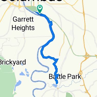
Fall Line Trace
Una ruta en bici que comienza en Columbus, Georgia, Estados Unidos.
Visión General
Sobre esta ruta
Este es un proyecto de caminos de ferrocarril a senderos. Comienza en bosques agradables y emerge en el centro de la ciudad. Las intersecciones con las carreteras están bien señalizadas hasta que te acercas al centro médico. En ese momento, el sendero cambia a carreteras y solo está marcado con símbolos de bicicleta en la carretera y algunos letreros de 'Share the Road'. Hay estacionamiento al principio. Dado que terminas en el centro de la ciudad, puedes ir a un restaurante para almorzar y luego regresar.
- -:--
- Duración
- 16,6 km
- Distancia
- 77 m
- Ascenso
- 147 m
- Descenso
- ---
- Velocidad Media
- ---
- Altitud máxima
Calidad de la ruta
Tipos de vía y superficies a lo largo de la ruta
Tipos de vía
Carril bici
14,8 km
(89 %)
Carretera
0,7 km
(4 %)
Superficies
Pavimentado
6 km
(36 %)
Asfalto
4,6 km
(28 %)
Pavimentado (sin definir)
1,3 km
(8 %)
Sin definir
10,6 km
(64 %)
Continuar con Bikemap
Usa, edita o descarga esta ruta en bici
¿Te gustaría recorrer Fall Line Trace o personalizarla para tu propio viaje? Esto es lo que puedes hacer con esta ruta de Bikemap:
Funciones gratuitas
- Guarda esta ruta como favorita o en una colección
- Copia y planifica tu propia versión de esta ruta
- Sincroniza tu ruta con Garmin o Wahoo
Funciones Premium
Prueba gratuita de 3 días o pago único. Más información sobre Bikemap Premium.
- Navega esta ruta en iOS y Android
- Exporta un archivo GPX / KML de esta ruta
- Crea tu impresión personalizada (pruébala gratis)
- Descarga esta ruta para la navegación sin conexión
Descubre más funciones Premium.
Consigue Bikemap PremiumDe nuestra comunidad
Columbus: Otras rutas populares que empiezan aquí
 riverwalk
- Distancia
- 20,9 km
- Ascenso
- 70 m
- Descenso
- 73 m
- Ubicación
- Columbus, Georgia, Estados Unidos
 1300 Victory Dr, Columbus to 1300 Victory Dr, Columbus
- Distancia
- 16,1 km
- Ascenso
- 150 m
- Descenso
- 152 m
- Ubicación
- Columbus, Georgia, Estados Unidos
 1300 Victory Dr, Columbus to 1300 Victory Dr, Columbus
- Distancia
- 16,1 km
- Ascenso
- 123 m
- Descenso
- 125 m
- Ubicación
- Columbus, Georgia, Estados Unidos
 Route naar Fort Benning
- Distancia
- 55,3 km
- Ascenso
- 242 m
- Descenso
- 239 m
- Ubicación
- Columbus, Georgia, Estados Unidos
 Clubview Dr, Columbus to Psalmond Rd, Columbus
- Distancia
- 11 km
- Ascenso
- 40 m
- Descenso
- 0 m
- Ubicación
- Columbus, Georgia, Estados Unidos
 Pastviny - Columbus
- Distancia
- 22,1 km
- Ascenso
- 91 m
- Descenso
- 91 m
- Ubicación
- Columbus, Georgia, Estados Unidos
 1300 Victory Dr, Columbus to 1300 Victory Dr, Columbus
- Distancia
- 22,5 km
- Ascenso
- 161 m
- Descenso
- 160 m
- Ubicación
- Columbus, Georgia, Estados Unidos
 1300 Victory Dr, Columbus to 1300 Victory Dr, Columbus
- Distancia
- 16,2 km
- Ascenso
- 82 m
- Descenso
- 85 m
- Ubicación
- Columbus, Georgia, Estados Unidos
Ábrela en la app

