- 78,7 km
- 519 m
- 519 m
- Queensferry, Escocia, Reino Unido
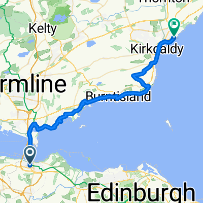
St Margarets Way-South Queensferry to Burntisland
Una ruta en bici que comienza en Queensferry, Escocia, Reino Unido.
Visión General
Sobre esta ruta
Al cruzar el puente de la carretera, cientos de pies sobre el Firth en una pasarela especial para bicicletas/caminantes, el Camino desciende hacia North Queensferry donde, directamente debajo del famoso puente ferroviario, se une al Fife Coastal Path. Este camino abraza la costa dominada por grandes acantilados de magma, recordatorios del pasado volcánico de Escocia, hasta Dalgety Bay. Grandes vistas mirando hacia atrás a los famosos puentes de Forth.
Siguiendo el Fife Coastal Path y la Ruta Nacional de Bicicleta señalizados, el Camino continúa por caminos tranquilos y senderos forestales y la famosa isla de Inchcolm aparece a la vista. Luego, pasa por la iglesia de St Bridget’s, entrando en el bonito pueblo pesquero de Aberdour, dominado por su castillo, y baja hasta el puerto. Luego, a lo largo del Fife Coastal Path alrededor de bahías y por tramos boscosos hacia la concurrida ciudad de Burnt Island. Plano y fácil de recorrer. Muchos comercios y pubs y carteles informativos a lo largo del camino.
Esta es la 2ª sección de St Margaret’s Way, la gran ruta de peregrinación de 100 km desde Edimburgo a St Andrews, parte de la recuperación de la peregrinación de 1000 años de antigüedad, The Way of St Andrews. (http://www.thewayofstandrews.com)
- -:--
- Duración
- 20,4 km
- Distancia
- 165 m
- Ascenso
- 170 m
- Descenso
- ---
- Velocidad Media
- ---
- Altitud máxima
creado hace 13 años
Destacados de la ruta
Puntos de interés a lo largo de la ruta

Punto de interés después de 15,4 km
Many million years ago this was a region of active volcanoes. Here is where, deep down, a flow of molten rock (light grey) was squeezed between layers of sandstone. Called a sill, the molten rock contains bits of sandstone which it plucked up as it flowed. Thanks to geoHeritage Fife for advice and image.
Continuar con Bikemap
Usa, edita o descarga esta ruta en bici
¿Te gustaría recorrer St Margarets Way-South Queensferry to Burntisland o personalizarla para tu propio viaje? Esto es lo que puedes hacer con esta ruta de Bikemap:
Funciones gratuitas
- Guarda esta ruta como favorita o en una colección
- Copia y planifica tu propia versión de esta ruta
- Sincroniza tu ruta con Garmin o Wahoo
Funciones Premium
Prueba gratuita de 3 días o pago único. Más información sobre Bikemap Premium.
- Navega esta ruta en iOS y Android
- Exporta un archivo GPX / KML de esta ruta
- Crea tu impresión personalizada (pruébala gratis)
- Descarga esta ruta para la navegación sin conexión
Descubre más funciones Premium.
Consigue Bikemap PremiumDe nuestra comunidad
Queensferry: Otras rutas populares que empiezan aquí
- South Queensferry to Royal Dunkeld Hotel
- Stage 6 to Moff
- 108 km
- 841 m
- 748 m
- Queensferry, Escocia, Reino Unido
- Almond, South Queensferry to South Clerk Street, Edinburgh
- 17,4 km
- 218 m
- 189 m
- Queensferry, Escocia, Reino Unido
- Sunday afternoon ride
- 22,1 km
- 174 m
- 173 m
- Queensferry, Escocia, Reino Unido
- FRB to Commie
- 21,5 km
- 166 m
- 122 m
- Queensferry, Escocia, Reino Unido
- From South Queensferry to Kirkcaldy
- 35,1 km
- 400 m
- 435 m
- Queensferry, Escocia, Reino Unido
- Day 24 Queensferry to Perth
- 53,2 km
- 470 m
- 508 m
- Queensferry, Escocia, Reino Unido
- St Margarets Way-South Queensferry to Burntisland
- 20,4 km
- 165 m
- 170 m
- Queensferry, Escocia, Reino Unido
Ábrela en la app


