

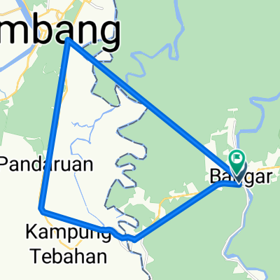
Bangar, bike and Bukit Patoi
Una ruta en bici que comienza en Bangar, Temburong, Brunéi.
Visión General
Sobre esta ruta
Esta es una ruta combinada de ciclismo y caminata, de Bangar a Bukit Patoi. La carretera es una excelente autopista, mayormente con un amplio arcén, y la subida de 300 m hasta Bukit Patoi sigue un sendero muy utilizado. Al pie de la subida hay edificios, incluidos baños y agua. Asegúrate de beber con frecuencia.
Es mejor hacerlo temprano en la mañana para evitar el calor. Aun así, sudarás mucho. El paseo y la caminata tardan poco más de media hora cada uno, así que date tres horas para explorar y completarlo.
Una mochila de día con un par de botas antideslizantes y un par de botellas de agua es una buena idea. El mayor peligro son los resbaladizos escalones de concreto (pintados) al principio de la subida. Mantén una mano en la barandilla al bajar, ya que la lluvia y el musgo empeoran las cosas.
- -:--
- Duración
- 16,1 km
- Distancia
- 388 m
- Ascenso
- 109 m
- Descenso
- ---
- Velocidad Media
- ---
- Altitud máxima

Continuar con Bikemap
Usa, edita o descarga esta ruta en bici
¿Te gustaría recorrer Bangar, bike and Bukit Patoi o personalizarla para tu propio viaje? Esto es lo que puedes hacer con esta ruta de Bikemap:
Funciones gratuitas
- Guarda esta ruta como favorita o en una colección
- Copia y planifica tu propia versión de esta ruta
- Sincroniza tu ruta con Garmin o Wahoo
Funciones Premium
Prueba gratuita de 3 días o pago único. Más información sobre Bikemap Premium.
- Navega esta ruta en iOS y Android
- Exporta un archivo GPX / KML de esta ruta
- Crea tu impresión personalizada (pruébala gratis)
- Descarga esta ruta para la navegación sin conexión
Descubre más funciones Premium.
Consigue Bikemap PremiumDe nuestra comunidad
Bangar: Otras rutas populares que empiezan aquí
 Brunei, Bangar to Brunei, Bangar
- Distancia
- 2 km
- Ascenso
- 12 m
- Descenso
- 12 m
- Ubicación
- Bangar, Temburong, Brunéi
 Labu logging track
- Distancia
- 13,9 km
- Ascenso
- 455 m
- Descenso
- 452 m
- Ubicación
- Bangar, Temburong, Brunéi
 Bangar Puni Bukok Rataie Loop
- Distancia
- 27,4 km
- Ascenso
- 303 m
- Descenso
- 301 m
- Ubicación
- Bangar, Temburong, Brunéi
 Bukit Patoi extension walk
- Distancia
- 1,1 km
- Ascenso
- 88 m
- Descenso
- 28 m
- Ubicación
- Bangar, Temburong, Brunéi
 Afternoon Ride
- Distancia
- 15 km
- Ascenso
- 157 m
- Descenso
- 133 m
- Ubicación
- Bangar, Temburong, Brunéi
 Blistering ride
- Distancia
- 22,3 km
- Ascenso
- 49 m
- Descenso
- 39 m
- Ubicación
- Bangar, Temburong, Brunéi
 Restful route
- Distancia
- 40,4 km
- Ascenso
- 31 m
- Descenso
- 84 m
- Ubicación
- Bangar, Temburong, Brunéi
 Temburong Practice Run
- Distancia
- 13 km
- Ascenso
- 102 m
- Descenso
- 86 m
- Ubicación
- Bangar, Temburong, Brunéi
Ábrela en la app