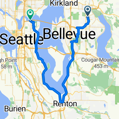
Lake Sam & Juanita hill Figure eight
Una ruta en bici que comienza en Redmond, Washington, Estados Unidos.
Visión General
Sobre esta ruta
Comienza en Lake Sam y pasa por Rose Hill O toma el sendero 520 hacia Kirkland y continúa por Lake WA Blvd. Ve hacia el norte pasando por las colinas de Market y Juanita hasta Kenmore. Incorpórate al Burke Trail y mantente en él hasta después del túnel cerca del campo de golf, luego cruza el puente alto en lugar del sendero y toma la calle cerca del parque Bythe?. Gira a la izquierda y sigue hasta llegar a la bodega. Sigue la carretera y vuelve al sendero. Ve hacia el sur y luego rodea el lago. Utilizo esta ruta todo el tiempo para entrenar para el STP y añado algunos kilómetros extra para completar entre 60 y 70 millas. Varias colinas largas y un paisaje agradable. Esta es una gran aplicación, pero no es ideal para pasar de senderos pavimentados a calles. Hay varios senderos que conocen los locales, por lo que te animaría a probar también esos.
- -:--
- Duración
- 94,1 km
- Distancia
- 673 m
- Ascenso
- 615 m
- Descenso
- ---
- Velocidad Media
- ---
- Altitud máxima
Calidad de la ruta
Tipos de vía y superficies a lo largo de la ruta
Tipos de vía
Carretera
10,3 km
(11 %)
Carretera tranquila
10,3 km
(11 %)
Superficies
Pavimentado
70,6 km
(75 %)
Asfalto
64,9 km
(69 %)
Hormigón
3,8 km
(4 %)
Continuar con Bikemap
Usa, edita o descarga esta ruta en bici
¿Te gustaría recorrer Lake Sam & Juanita hill Figure eight o personalizarla para tu propio viaje? Esto es lo que puedes hacer con esta ruta de Bikemap:
Funciones gratuitas
- Guarda esta ruta como favorita o en una colección
- Copia y planifica tu propia versión de esta ruta
- Divídelo en etapas para crear una excursión de varios días
- Sincroniza tu ruta con Garmin o Wahoo
Funciones Premium
Prueba gratuita de 3 días o pago único. Más información sobre Bikemap Premium.
- Navega esta ruta en iOS y Android
- Exporta un archivo GPX / KML de esta ruta
- Crea tu impresión personalizada (pruébala gratis)
- Descarga esta ruta para la navegación sin conexión
Descubre más funciones Premium.
Consigue Bikemap PremiumDe nuestra comunidad
Redmond: Otras rutas populares que empiezan aquí
 Lake Sam & Juanita hill Figure eight
- Distancia
- 94,1 km
- Ascenso
- 673 m
- Descenso
- 615 m
- Ubicación
- Redmond, Washington, Estados Unidos
 Redmond to Rail underlake
- Distancia
- 48,2 km
- Ascenso
- 188 m
- Descenso
- 279 m
- Ubicación
- Redmond, Washington, Estados Unidos
 2012 Flying Wheels - 65 Mile Route
- Distancia
- 105 km
- Ascenso
- 639 m
- Descenso
- 639 m
- Ubicación
- Redmond, Washington, Estados Unidos
 East Lake Sammamish Parkway Northeast 6411, Redmond to East Lake Sammamish Parkway Northeast 6411, Redmond
- Distancia
- 40 km
- Ascenso
- 193 m
- Descenso
- 193 m
- Ubicación
- Redmond, Washington, Estados Unidos
 Flying Wheels Summer Century
- Distancia
- 156,5 km
- Ascenso
- 558 m
- Descenso
- 558 m
- Ubicación
- Redmond, Washington, Estados Unidos
 17525 NE 65th St, Redmond to 17525 NE 65th St, Redmond
- Distancia
- 14,5 km
- Ascenso
- 12 m
- Descenso
- 13 m
- Ubicación
- Redmond, Washington, Estados Unidos
 Overlake to Bellevue Downtown Park
- Distancia
- 9,9 km
- Ascenso
- 141 m
- Descenso
- 198 m
- Ubicación
- Redmond, Washington, Estados Unidos
 Potato pancake breakfast ride
- Distancia
- 8,2 km
- Ascenso
- 17 m
- Descenso
- 24 m
- Ubicación
- Redmond, Washington, Estados Unidos
Ábrela en la app

