

Star Cycles - Ansteys Hill
Una ruta en bici que comienza en Elizabeth, State of South Australia, Australia.
Visión General
Sobre esta ruta
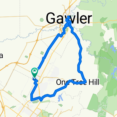
Dejando Star Cycles, montamos por Bellchambers Rd hacia West Av, pasando por la base aérea y luego a la izquierda en Purling Av. A la derecha en Commercial Rd y a la izquierda en Bagsters Rd, siguiendo esto hasta Burton Rd, donde otro giro a la izquierda nos lleva a Martins Rd, donde giramos a la derecha. Luego a la izquierda en Kings Rd, la cual cruzamos sobre la MN Rd y subimos McIntyre hasta que giramos a la izquierda en Montague Rd. Girando a la derecha en Reservoir Rd, pasamos TTP y continuamos hacia Grand Junction Rd, donde giramos a la izquierda y nos dirigimos hacia Ansteys Hill. Después de la subida constante, giramos a la derecha en la cima de Ansteys y bajamos por la pintoresca Range Rd South hasta Lower NE Rd, donde giramos a la izquierda brevemente antes de un giro a la derecha en Range Rd North. Una subida constante es seguida por un rápido descenso, pero ten cuidado con la curva cerrada a mitad de camino y el T- junctión en Seaview Rd donde giramos a la izquierda y seguimos hacia abajo en Yatala Vale Rd y la panadería Prices en Golden Grove Village. Después de nuestra pausa, continuamos por Grove Way, cruzamos la MN Rd hasta Saints Rd, Fenden Rd y a la derecha en Ponton St. A la derecha en Commercial Rd, luego a la derecha de nuevo en John Rice Av de regreso a Elizabeth Way y Star Cycles.
- -:--
- Duración
- 58,8 km
- Distancia
- 536 m
- Ascenso
- 542 m
- Descenso
- ---
- Velocidad Media
- ---
- Altitud máxima
Calidad de la ruta
Tipos de vía y superficies a lo largo de la ruta
Tipos de vía
Carretera
17,6 km
(30 %)
Carretera tranquila
9,4 km
(16 %)
Superficies
Pavimentado
55,9 km
(95 %)
Asfalto
43,5 km
(74 %)
Pavimentado (sin definir)
11,8 km
(20 %)
Continuar con Bikemap
Usa, edita o descarga esta ruta en bici
¿Te gustaría recorrer Star Cycles - Ansteys Hill o personalizarla para tu propio viaje? Esto es lo que puedes hacer con esta ruta de Bikemap:
Funciones gratuitas
- Guarda esta ruta como favorita o en una colección
- Copia y planifica tu propia versión de esta ruta
- Sincroniza tu ruta con Garmin o Wahoo
Funciones Premium
Prueba gratuita de 3 días o pago único. Más información sobre Bikemap Premium.
- Navega esta ruta en iOS y Android
- Exporta un archivo GPX / KML de esta ruta
- Crea tu impresión personalizada (pruébala gratis)
- Descarga esta ruta para la navegación sin conexión
Descubre más funciones Premium.
Consigue Bikemap PremiumDe nuestra comunidad
Elizabeth: Otras rutas populares que empiezan aquí
 Star Cycles - Sandy Creek - hillier rd
- Distancia
- 59,8 km
- Ascenso
- 196 m
- Descenso
- 196 m
- Ubicación
- Elizabeth, State of South Australia, Australia
 trip...
- Distancia
- 11,6 km
- Ascenso
- 25 m
- Descenso
- 56 m
- Ubicación
- Elizabeth, State of South Australia, Australia
 Star Cycles Inglewood-COP-Kersbrook
- Distancia
- 64 km
- Ascenso
- 717 m
- Descenso
- 717 m
- Ubicación
- Elizabeth, State of South Australia, Australia
 Yorktown Road 32, Elizabeth East to McCormack Crescent 50, Salisbury North
- Distancia
- 20,9 km
- Ascenso
- 255 m
- Descenso
- 285 m
- Ubicación
- Elizabeth, State of South Australia, Australia
 One Tree Hill Scenic route Gawler
- Distancia
- 57,1 km
- Ascenso
- 330 m
- Descenso
- 330 m
- Ubicación
- Elizabeth, State of South Australia, Australia
 Elizabeth East to Hilton South Australia
- Distancia
- 30,5 km
- Ascenso
- 48 m
- Descenso
- 91 m
- Ubicación
- Elizabeth, State of South Australia, Australia
 Angaston to Handorf
- Distancia
- 234,1 km
- Ascenso
- 1334 m
- Descenso
- 1333 m
- Ubicación
- Elizabeth, State of South Australia, Australia
 Elizabeth to Keswick (BikeSA) via Torrens River Trail
- Distancia
- 42,3 km
- Ascenso
- 275 m
- Descenso
- 327 m
- Ubicación
- Elizabeth, State of South Australia, Australia
Ábrela en la app