34km Ride – Gentle Hills and Peaceful Roads
Una ruta en bici que comienza en Exeter, Inglaterra, Reino Unido.
Visión General
Sobre esta ruta
Disfruta de un recorrido de 34 km por una mezcla de carreteras tranquilas y carriles bici dedicados. Ideal para principiantes, con una navegación fácil y cambios de altitud graduales. Una gran opción tanto para ciclistas nuevos como experimentados.
Comienza en los carriles bici de Exeter, siguiendo cualquier señal hacia el "Science Park". Una vez que cruces el puente Redhayes sobre la M5, sigue las señales hacia el aeropuerto.
Después de Clyst Honiton, llegarás a una rotonda: asegúrate de seguir el carril bici hacia el aparcamiento del aeropuerto para evitar la carretera principal.
Si necesitas un café, puedes girar a la derecha en el carril bici compartido al salir del aparcamiento y dirigirte a "The Crusty Cob". Esto romperá la suave subida de 6 km desde Clyst Honiton hasta Aylesbeare. (Nota: Crusty Cob ahora está cerrado)
Si prefieres seguir, sal del aparcamiento del aeropuerto, cruza la carretera y continúa pasando la entrada del aeropuerto por una tranquila carretera rural.
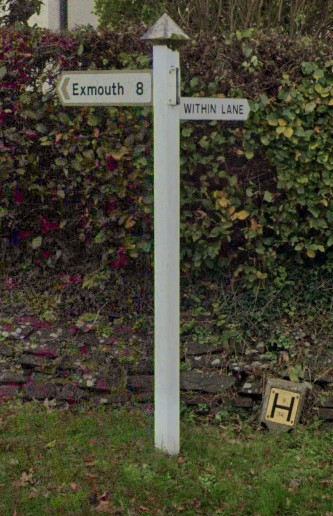
Después de pasar por Westcott, sigue las señales hacia Aylesbeare. Al pasar por Aylesbeare, hay un cartel blanco a la derecha para "Within Lane". Al final de Within Lane, gira a la izquierda.
Si quieres evitar el mal estado de la carretera, gira a la derecha y luego a la izquierda en el pub "The White Horse". Esto es especialmente recomendable si llevas una bicicleta de carretera o si el clima es malo. De lo contrario, ten cuidado al cruzar la carretera principal y continúa recto, luego gira a la derecha en el triángulo.
Sigue las señales hacia "Woodbury". En Woodbury hay una tienda local y un pub si necesitas refrescos.
Cerca del centro de Woodbury, hay una pequeña señal de madera para "Ebford, Exe Estuary Trail" que puede pasarse por alto fácilmente.
Al momento de escribir, cuando entras en Ebford, la señalización marrón para el "Exe Estuary Trail" está rota. Asegúrate de girar a la izquierda al ver las primeras casas de Ebford.
Sigue las señales para el "Exe Estuary Trail" hasta que veas señales azules para "Topsham" o "Exeter". Hacia el final del recorrido, hay muchas oportunidades para comer y beber en Topsham y Exeter, lo que lo convierte en una parada perfecta después del paseo.
- 2 h 3 min
- Duración
- 34,1 km
- Distancia
- 210 m
- Ascenso
- 212 m
- Descenso
- 16,6 km/h
- Velocidad Media
- 99 m
- Altitud máxima
Fotos de la ruta
Calidad de la ruta
Tipos de vía y superficies a lo largo de la ruta
Tipos de vía
Carretera tranquila
18,1 km
(53 %)
Carril bici
10,9 km
(32 %)
Superficies
Pavimentado
20,1 km
(59 %)
Asfalto
19,8 km
(58 %)
Pavimentado (sin definir)
0,3 km
(1 %)
Sin definir
14 km
(41 %)
Continuar con Bikemap
Usa, edita o descarga esta ruta en bici
¿Te gustaría recorrer 34km Ride – Gentle Hills and Peaceful Roads o personalizarla para tu propio viaje? Esto es lo que puedes hacer con esta ruta de Bikemap:
Funciones gratuitas
- Guarda esta ruta como favorita o en una colección
- Copia y planifica tu propia versión de esta ruta
- Sincroniza tu ruta con Garmin o Wahoo
Funciones Premium
Prueba gratuita de 3 días o pago único. Más información sobre Bikemap Premium.
- Navega esta ruta en iOS y Android
- Exporta un archivo GPX / KML de esta ruta
- Crea tu impresión personalizada (pruébala gratis)
- Descarga esta ruta para la navegación sin conexión
Descubre más funciones Premium.
Consigue Bikemap PremiumDe nuestra comunidad
Exeter: Otras rutas populares que empiezan aquí
 Exeter, Dawlish, Ashcombe circuit
- Distancia
- 50,1 km
- Ascenso
- 521 m
- Descenso
- 521 m
- Ubicación
- Exeter, Inglaterra, Reino Unido
 Exeter-Two Bridges-Chudleigh-Exeter
- Distancia
- 98,3 km
- Ascenso
- 1027 m
- Descenso
- 1032 m
- Ubicación
- Exeter, Inglaterra, Reino Unido
 Bikeroute for Sue
- Distancia
- 32,6 km
- Ascenso
- 270 m
- Descenso
- 216 m
- Ubicación
- Exeter, Inglaterra, Reino Unido
 34km Ride – Gentle Hills and Peaceful Roads
- Distancia
- 34,1 km
- Ascenso
- 210 m
- Descenso
- 212 m
- Ubicación
- Exeter, Inglaterra, Reino Unido
 30 miles 2500ft
- Distancia
- 52,7 km
- Ascenso
- 472 m
- Descenso
- 486 m
- Ubicación
- Exeter, Inglaterra, Reino Unido
 Fosterville loop
- Distancia
- 47,7 km
- Ascenso
- 553 m
- Descenso
- 555 m
- Ubicación
- Exeter, Inglaterra, Reino Unido
 Feniton-Silverton
- Distancia
- 57,9 km
- Ascenso
- 410 m
- Descenso
- 410 m
- Ubicación
- Exeter, Inglaterra, Reino Unido
 Fernworthy circuit from Exeter
- Distancia
- 76,9 km
- Ascenso
- 871 m
- Descenso
- 871 m
- Ubicación
- Exeter, Inglaterra, Reino Unido
Ábrela en la app


