
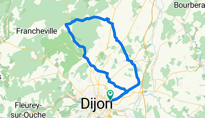
2009 Euro Tour -- Ride Day 14 — 7 July 2009 — 21850 St-Apollinaire (Dijon) -- Circle
Una ruta en bici que comienza en Saint-Apollinaire, Borgoña-Franco Condado, Francia.
Visión General
Sobre esta ruta
Decidimos quedarnos dos noches más en Dijon, así que hicimos una gran ruta hacia la zona al norte de la ciudad. Afortunadamente, a pesar del pronóstico de tiempo soleado, llevamos nuestros abrigos y cubre zapatos impermeables porque terminamos mojándonos un poco. No fue tan intensa como la lluvia que tuvimos al principio del viaje, pero suficiente para estar bastante mojados.
En esta ruta, la larga subida de 9 km por la D996, desde aproximadamente 300 metros hasta 554 metros, fue definitivamente una buena sección de entrenamiento.
En el camino de regreso, gracias al conocimiento adquirido al perdernos ayer, pudimos encontrar el Carrefour fácilmente. Eso nos permitió comprar comida para la cena y los próximos días sin problema. Anoche cenamos algo escaso en la habitación, consumiendo toda la comida que nos quedaba. Como llegamos bastante tarde después de todo el tiempo pedaleando por Dijon, no tuvimos tiempo para ir a una tienda.
Antecedentes:
Mi esposa y yo hemos estado haciendo tours auto-sostenidos en Europa Occidental (mayormente en Francia) desde 1993. Esta serie de rutas cubre nuestro recorrido de 2009, de 4.5 meses, por partes de Francia, Alemania, Austria, Suiza, y luego de vuelta a Francia. Nuestro punto de inicio y fin está cerca de Chadurie (al sur de Angouleme), donde nuestros amigos tienen una granja con Gites y Chambres d'Hotes.
Montamos nuestras bicicletas de turismo Dawes compradas en 1993, cargadas con neumáticos 700Cx32. Todo nuestro recorrido fue por carreteras pavimentadas, mayormente con muy poco tráfico. Prácticamente los únicos tramos sin pavimentar fueron algunos caminos para bicicletas en Alemania y Austria. Lamentablemente, eso no fue tan bueno ya que Helen se cayó varias veces en esos caminos sin pavimento. Afortunadamente, sin lesiones graves.
Si tienen preguntas, no duden en enviarme un correo a jeffkadet@netdiving.com
Jeff
- -:--
- Duración
- 60,6 km
- Distancia
- 461 m
- Ascenso
- 460 m
- Descenso
- ---
- Velocidad Media
- ---
- Altitud máxima

Calidad de la ruta
Tipos de vía y superficies a lo largo de la ruta
Tipos de vía
Carretera
21,2 km
(35 %)
Carretera tranquila
10,9 km
(18 %)
Superficies
Pavimentado
27,9 km
(46 %)
Asfalto
27,9 km
(46 %)
Sin definir
32,7 km
(54 %)
Continuar con Bikemap
Usa, edita o descarga esta ruta en bici
¿Te gustaría recorrer 2009 Euro Tour -- Ride Day 14 — 7 July 2009 — 21850 St-Apollinaire (Dijon) -- Circle o personalizarla para tu propio viaje? Esto es lo que puedes hacer con esta ruta de Bikemap:
Funciones gratuitas
- Guarda esta ruta como favorita o en una colección
- Copia y planifica tu propia versión de esta ruta
- Sincroniza tu ruta con Garmin o Wahoo
Funciones Premium
Prueba gratuita de 3 días o pago único. Más información sobre Bikemap Premium.
- Navega esta ruta en iOS y Android
- Exporta un archivo GPX / KML de esta ruta
- Crea tu impresión personalizada (pruébala gratis)
- Descarga esta ruta para la navegación sin conexión
Descubre más funciones Premium.
Consigue Bikemap PremiumDe nuestra comunidad
Saint-Apollinaire: Otras rutas populares que empiezan aquí
 Bignol 42 km
- Distancia
- 42 km
- Ascenso
- 286 m
- Descenso
- 283 m
- Ubicación
- Saint-Apollinaire, Borgoña-Franco Condado, Francia
 Dijon_links zum Kanal 50 km
- Distancia
- 50,8 km
- Ascenso
- 295 m
- Descenso
- 291 m
- Ubicación
- Saint-Apollinaire, Borgoña-Franco Condado, Francia
 2009 Euro Tour -- Ride Day 14 — 7 July 2009 — 21850 St-Apollinaire (Dijon) -- Circle
- Distancia
- 60,6 km
- Ascenso
- 461 m
- Descenso
- 460 m
- Ubicación
- Saint-Apollinaire, Borgoña-Franco Condado, Francia
 Dijon Turcey Bussy Pasques Dijon
- Distancia
- 100,2 km
- Ascenso
- 750 m
- Descenso
- 750 m
- Ubicación
- Saint-Apollinaire, Borgoña-Franco Condado, Francia
 DIJON - CHAMPS /Marne
- Distancia
- 447 km
- Ascenso
- 367 m
- Descenso
- 572 m
- Ubicación
- Saint-Apollinaire, Borgoña-Franco Condado, Francia
 From Dijon to Gissey-sur-Ouche
- Distancia
- 30,9 km
- Ascenso
- 171 m
- Descenso
- 120 m
- Ubicación
- Saint-Apollinaire, Borgoña-Franco Condado, Francia
 BOURGOGNE Côte d'or - Randonnée des sources (21)
- Distancia
- 157,8 km
- Ascenso
- 1193 m
- Descenso
- 1194 m
- Ubicación
- Saint-Apollinaire, Borgoña-Franco Condado, Francia
 Le Tour De France: Stage 7
- Distancia
- 177,9 km
- Ascenso
- 215 m
- Descenso
- 240 m
- Ubicación
- Saint-Apollinaire, Borgoña-Franco Condado, Francia
Ábrela en la app