Restful route in Pullay
- 4,3 km
- 15 m
- 0 m
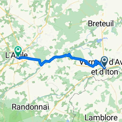
- Verneuil-sur-Avre, Normandía, Francia
Una ruta en bici que comienza en Verneuil-sur-Avre, Normandía, Francia.
Visión General
Buen paseo hoy aunque tuvimos vientos en contra fuertes. Afortunadamente, en la segunda mitad del recorrido tuvimos variedad de terreno y excelentes carreteras. La D137 tuvo una subida terrible que merecía al menos dos flechas en lugar de la única que aparece en el mapa. Justo después de la subida, al pedalear por la D613 rumbo al Etap, comenzó a llover, como el día anterior justo antes de llegar a nuestro destino. Durante el día, pasamos por períodos cortos del departamento de Eure en la región de Alta Normandía al departamento de Orne en la región de Baja Normandía. Finalmente, salimos del departamento de Eure y entramos en el departamento de Calvados, que también pertenece a la región de Baja Normandía. Antecedentes: Mi esposa y yo hemos estado realizando tours auto-suficientes en Europa occidental (la mayoría en Francia) desde 1993. Esta serie de recorridos cubre nuestra ruta de 4,5 meses en 2009 por partes de Francia, Alemania, Austria, Suiza y luego de regreso a Francia. Nuestro punto de inicio y final es cerca de Chadurie (al sur de Angulema) donde nuestros amigos tienen una granja con Gites y Chambres d'Hotes. Montamos nuestras bicicletas de turismo Dawes, compradas en 1993, cargadas con neumáticos 700Cx32. Todo nuestro recorrido fue por carreteras pavimentadas, mayormente con muy poco tráfico. Prácticamente los únicos tramos sin pavimentar fueron algunos caminos para bicicletas en Alemania y Austria. Por desgracia, eso no fue tan bueno ya que Helen se cayó varias veces en los caminos sin pavimentar. Afortunadamente, sin lesiones graves. Si tienen alguna pregunta, pueden enviarme un correo a jeffkadet@netdiving.com. Jeff
creado hace 13 años
Calidad de la ruta
Carretera
18,5 km
23 %
Carretera tranquila
15,3 km
19 %
Pavimentado
16,9 km
(21 %)
Sin pavimentar
0,8 km
(1 %)
Asfalto
16,9 km
21 %
Suelo
0,8 km
1 %
Sin definir
62,7 km
78 %
Continuar con Bikemap
¿Te gustaría recorrer 2009 Euro Tour -- Ride Day 20 — 15 July 2009 — 27130 Verneuil-sur-Avre to 14100 Lisieux CLONED FROM ROUTE 1682062 o personalizarla para tu propio viaje? Esto es lo que puedes hacer con esta ruta de Bikemap:
Prueba gratuita de 3 días o pago único. Más información sobre Bikemap Premium.
Descubre más funciones Premium.
Consigue Bikemap PremiumDe nuestra comunidad
Ábrela en la app