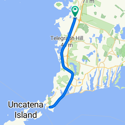
Shining Sea Bike Path, Falmouth MA CLONED FROM ROUTE 725885
Una ruta en bici que comienza en North Falmouth, Massachusetts, United States of America.
Visión General
Sobre esta ruta
One end of the bike path is in North Falmouth and the other is in Woods Hole. The path follows the old railroad grade so is fairly flat with gradual rises. It is for bicycles, running, roller blades, and walking.
It passes by salt marshes and beaches while traveling through some woods. The views along the path are to the west so the sunset over the salt marshes can be amazing.
There are a number of ice cream shops along the way as well as a few restaurants. Parking lots are at both ends and a few along the way. On weekends during the summer thousands of people use the path during the day, but in early evening the numbers have thinned out. Fall is a great time to see the foliage and relatively few people on the path.
- -:--
- Duración
- 17,1 km
- Distancia
- 98 m
- Ascenso
- 114 m
- Descenso
- ---
- Velocidad Media
- ---
- Altitud máxima
Continuar con Bikemap
Usa, edita o descarga esta ruta en bici
¿Te gustaría recorrer Shining Sea Bike Path, Falmouth MA CLONED FROM ROUTE 725885 o personalizarla para tu propio viaje? Esto es lo que puedes hacer con esta ruta de Bikemap:
Funciones gratuitas
- Guarda esta ruta como favorita o en una colección
- Copia y planifica tu propia versión de esta ruta
- Sincroniza tu ruta con Garmin o Wahoo
Funciones Premium
Prueba gratuita de 3 días o pago único. Más información sobre Bikemap Premium.
- Navega esta ruta en iOS y Android
- Exporta un archivo GPX / KML de esta ruta
- Crea tu impresión personalizada (pruébala gratis)
- Descarga esta ruta para la navegación sin conexión
Descubre más funciones Premium.
Consigue Bikemap PremiumDe nuestra comunidad
North Falmouth: Otras rutas populares que empiezan aquí
 cape cod canal et bord de mer
- Distancia
- 86,3 km
- Ascenso
- 177 m
- Descenso
- 178 m
- Ubicación
- North Falmouth, Massachusetts, United States of America
 Shining Sea Bike Path, Falmouth MA CLONED FROM ROUTE 725885
- Distancia
- 17,1 km
- Ascenso
- 98 m
- Descenso
- 114 m
- Ubicación
- North Falmouth, Massachusetts, United States of America
 35 County Rd, North Falmouth to 35 County Rd, North Falmouth
- Distancia
- 34,7 km
- Ascenso
- 119 m
- Descenso
- 120 m
- Ubicación
- North Falmouth, Massachusetts, United States of America
 edward gorey loop_11/8
- Distancia
- 107,3 km
- Ascenso
- 117 m
- Descenso
- 135 m
- Ubicación
- North Falmouth, Massachusetts, United States of America
 Recovered Route
- Distancia
- 12,1 km
- Ascenso
- 35 m
- Descenso
- 39 m
- Ubicación
- North Falmouth, Massachusetts, United States of America
 Depot Rd, North Falmouth to 35 County Rd, North Falmouth
- Distancia
- 34,8 km
- Ascenso
- 132 m
- Descenso
- 132 m
- Ubicación
- North Falmouth, Massachusetts, United States of America
 Steady ride in North Falmouth
- Distancia
- 33,5 km
- Ascenso
- 6 m
- Descenso
- 23 m
- Ubicación
- North Falmouth, Massachusetts, United States of America
 Depot Rd, North Falmouth to 13 County Rd, North Falmouth
- Distancia
- 29,8 km
- Ascenso
- 116 m
- Descenso
- 110 m
- Ubicación
- North Falmouth, Massachusetts, United States of America
Ábrela en la app

