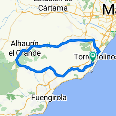
Carihuela- Cartama Coin Guaro Monda Mijas Carihuela
- 91,6 km
- 1013 m
- 1013 m
- Torremolinos, Andalucía, España
Una ruta en bici que comienza en Torremolinos, Andalucía, España.
Visión General
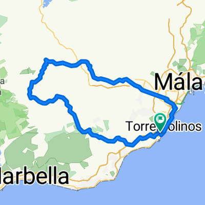
Moderate trip around lake Casasola towards majestic formation El Torcal and back. Any 90 km with views over valleys Barranco del Sol and Hoya de Malaga.From main square take street Calle Cisneros, turn right and then left across the bridge Aurora. All the time keep straight through streets Marmoles / M. Maldonado / Av. de C. Haya / Lope de Vega untill Puerto de la Torre. Then follow signs for Almogia, road A-7075.This A-7075 will lead you along lake Casasola to Villanueva de la Concepción through long and narrow valley Barranco del Sol. Steady 15 km long climb is impressive and finally appears huge massif of El Torcal. There will be strong climb to Villanueva. In the village turn left for Almogia through MA-3403. There you can enjoy views over N. P. Montes de Malaga on the left or Sierra del Valle del Abdalajis and even Sierra de las Nieves on the right. After 2 km turn right to undergo last steep section and then fastly down to village Los Nunez. Leave village, cross the bridge and on crossroad slightly turn right for Campanillas, road MA-415, later A-7058.From Campanillas just easily follow signs for Malaga again. - Moderate trip around lake Casasola towards majestic formation El Torcal and back. Any 90 km with views over valleys Barranco del Sol and Hoya de Malaga.From main square take street Calle Cisneros, turn right and then left across the bridge Aurora. All the time keep straight through streets Marmoles / M. Maldonado / Av. de C. Haya / Lope de Vega untill Puerto de la Torre. Then follow signs for Almogia, road A-7075.This A-7075 will lead you along lake Casasola to Villanueva de la Concepción through long and narrow valley Barranco del Sol. Steady 15 km long climb is impressive and finally appears huge massif of El Torcal. There will be strong climb to Villanueva. In the village turn left for Almogia through MA-3403. There you can enjoy views over N. P. Montes de Malaga on the left or Sierra del Valle del Abdalajis and even Sierra de las Nieves on the right. After 2 km turn right to undergo last steep section and then fastly down to village Los Nunez. Leave village, cross the bridge and on crossroad slightly turn right for Campanillas, road MA-415, later A-7058.From Campanillas just easily follow signs for Malaga again.
creado hace 1 mes
Calidad de la ruta
Carril bici
11,6 km
(11 %)
Carretera tranquila
8,4 km
(8 %)
Pavimentado
22,1 km
(21 %)
Sin pavimentar
1,1 km
(1 %)
Asfalto
11,6 km
(11 %)
Pavimentado (sin definir)
10,5 km
(10 %)
Continuar con Bikemap
¿Te gustaría recorrer RB-09 Malaga-PTO. Torre-Villanueva Concepcion-Almogia-Los Nunez-Campanillas-Malaga o personalizarla para tu propio viaje? Esto es lo que puedes hacer con esta ruta de Bikemap:
Prueba gratuita de 3 días o pago único. Más información sobre Bikemap Premium.
Descubre más funciones Premium.
Consigue Bikemap PremiumDe nuestra comunidad
Ábrela en la app