

Bush Beeline Loop
Una ruta en bici que comienza en Mesa, Arizona, Estados Unidos.
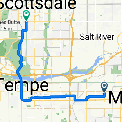
Visión General
Sobre esta ruta
Ride out to Saguaro Lake via Bush Highway, following Salt River; return on Beeline Highway. While there are large shoulders on highways at nearly all parts, be aware that Bush Highway is used heavily by boaters, and the Beeline is a 4-lane mostly-divided highway with very heavy traffic at times. Alternatives: Ride McKellips to Ellsworth and take the Usery Pass road, Take McDowell instead of McKellips, Use Gilbert Rd as a shortcut (places not rider friendly). Note that most of the route is through park/forest/reservation, so services (restrooms, water stops, etc) are limited. On the Beeline, a good stopping point is at the Fort McDowell Rd junction, or at Shea Blvd turn to Fountain Hills.
- -:--
- Duración
- 81,4 km
- Distancia
- 2229 m
- Ascenso
- 2229 m
- Descenso
- ---
- Velocidad Media
- ---
- Altitud máxima
Continuar con Bikemap
Usa, edita o descarga esta ruta en bici
¿Te gustaría recorrer Bush Beeline Loop o personalizarla para tu propio viaje? Esto es lo que puedes hacer con esta ruta de Bikemap:
Funciones gratuitas
- Guarda esta ruta como favorita o en una colección
- Copia y planifica tu propia versión de esta ruta
- Divídelo en etapas para crear una excursión de varios días
- Sincroniza tu ruta con Garmin o Wahoo
Funciones Premium
Prueba gratuita de 3 días o pago único. Más información sobre Bikemap Premium.
- Navega esta ruta en iOS y Android
- Exporta un archivo GPX / KML de esta ruta
- Crea tu impresión personalizada (pruébala gratis)
- Descarga esta ruta para la navegación sin conexión
Descubre más funciones Premium.
Consigue Bikemap PremiumDe nuestra comunidad
Mesa: Otras rutas populares que empiezan aquí
 73km Uptown Market
- Distancia
- 73,4 km
- Ascenso
- 67 m
- Descenso
- 65 m
- Ubicación
- Mesa, Arizona, Estados Unidos
 canal-pecans-Lindsey-brown-power-Alma school
- Distancia
- 70,2 km
- Ascenso
- 90 m
- Descenso
- 89 m
- Ubicación
- Mesa, Arizona, Estados Unidos
 Paragon to Rio Verde
- Distancia
- 90,8 km
- Ascenso
- 370 m
- Descenso
- 370 m
- Ubicación
- Mesa, Arizona, Estados Unidos
 Steady ride in Tempe
- Distancia
- 15,9 km
- Ascenso
- 38 m
- Descenso
- 64 m
- Ubicación
- Mesa, Arizona, Estados Unidos
 Spook Mtn 20
- Distancia
- 32 km
- Ascenso
- 191 m
- Descenso
- 189 m
- Ubicación
- Mesa, Arizona, Estados Unidos
 60km Mesa
- Distancia
- 60,5 km
- Ascenso
- 47 m
- Descenso
- 47 m
- Ubicación
- Mesa, Arizona, Estados Unidos
 24km morning ride
- Distancia
- 24 km
- Ascenso
- 29 m
- Descenso
- 27 m
- Ubicación
- Mesa, Arizona, Estados Unidos
 Home - Echo Coffee
- Distancia
- 17,4 km
- Ascenso
- 46 m
- Descenso
- 39 m
- Ubicación
- Mesa, Arizona, Estados Unidos
Ábrela en la app