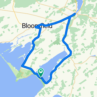
Recreational Trails Map - Gateway Country - Route 5
Una ruta en bici que comienza en Prince Edward, Ontario, Canadá.
Visión General
Sobre esta ruta
I just traced the route as outlined to get a reading on the distance because it was not included on the Recreational Trails Map (a large oversite in my opinion). The description given:<br />Picton - Sand Banks Loop - This is the beach tour, so be prpared for traffic on the weekends. Head west out of Picton on Hwy 33 to CR10 and follow south to Cherry Valley. Hug the shore of East Lake. At Salmon Point, turn right and pass through The Outlet and over to Sandbanks PP, or West Lake, as you chosse. Head back up West Lake Rd to the pretty village of Bloomfield, featuring a vibrant main street. Return to Picton along Hwy33. Generally flat, a few rolling hills on the last stretch.<br /><br /><br />If we bike it, I will add details.
- -:--
- Duración
- 40,4 km
- Distancia
- 107 m
- Ascenso
- 109 m
- Descenso
- ---
- Velocidad Media
- ---
- Altitud máxima
Continuar con Bikemap
Usa, edita o descarga esta ruta en bici
¿Te gustaría recorrer Recreational Trails Map - Gateway Country - Route 5 o personalizarla para tu propio viaje? Esto es lo que puedes hacer con esta ruta de Bikemap:
Funciones gratuitas
- Guarda esta ruta como favorita o en una colección
- Copia y planifica tu propia versión de esta ruta
- Sincroniza tu ruta con Garmin o Wahoo
Funciones Premium
Prueba gratuita de 3 días o pago único. Más información sobre Bikemap Premium.
- Navega esta ruta en iOS y Android
- Exporta un archivo GPX / KML de esta ruta
- Crea tu impresión personalizada (pruébala gratis)
- Descarga esta ruta para la navegación sin conexión
Descubre más funciones Premium.
Consigue Bikemap PremiumDe nuestra comunidad
Prince Edward: Otras rutas populares que empiezan aquí
 BloomfieldSandbanksloop
- Distancia
- 51,9 km
- Ascenso
- 127 m
- Descenso
- 134 m
- Ubicación
- Prince Edward, Ontario, Canadá
 May 17, 2015, 3:28 PM
- Distancia
- 38,3 km
- Ascenso
- 110 m
- Descenso
- 109 m
- Ubicación
- Prince Edward, Ontario, Canadá
 swamp college to church camp
- Distancia
- 33,4 km
- Ascenso
- 62 m
- Descenso
- 60 m
- Ubicación
- Prince Edward, Ontario, Canadá
 Recreational Trails Map - Gateway Country - Route 5
- Distancia
- 40,4 km
- Ascenso
- 107 m
- Descenso
- 109 m
- Ubicación
- Prince Edward, Ontario, Canadá
 Corto fondo
- Distancia
- 47,2 km
- Ascenso
- 111 m
- Descenso
- 111 m
- Ubicación
- Prince Edward, Ontario, Canadá
 canada day 100k
- Distancia
- 104,5 km
- Ascenso
- 126 m
- Descenso
- 126 m
- Ubicación
- Prince Edward, Ontario, Canadá
 Wellington Brighton Wellington
- Distancia
- 90,9 km
- Ascenso
- 204 m
- Descenso
- 205 m
- Ubicación
- Prince Edward, Ontario, Canadá
 randonnée de vacance
- Distancia
- 60,7 km
- Ascenso
- 241 m
- Descenso
- 238 m
- Ubicación
- Prince Edward, Ontario, Canadá
Ábrela en la app

