

Wulai-Neidong forest trail
Una ruta en bici que comienza en Banqiao District, Taipei, Taiwan.
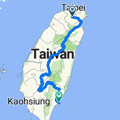
Visión General
Sobre esta ruta
<span style="color: #333333; font-family: 'lucida grande', tahoma, verdana, arial, sans-serif; font-size: 11px; line-height: 14px; white-space: pre-wrap;">Because the official entrance to the內洞林路 road has a police station (and is closed off) we had to turn and climb through a river bed for about 150m - probably the hardest part. There were also 2 big landslides which we needed to pass by climbing through the forest, and the last landslide was just before we got to the upper Neidong waterfall - that one is impossible to go around.</span><br style="color: #333333; font-family: 'lucida grande', tahoma, verdana, arial, sans-serif; font-size: 11px; line-height: 14px; white-space: pre-wrap;" /><span style="color: #333333; font-family: 'lucida grande', tahoma, verdana, arial, sans-serif; font-size: 11px; line-height: 14px; white-space: pre-wrap;">Then it's the stairs/trail down to the public waterfall area; that part is semi-ridable and sort of fun, if there aren't too many people coming up. Most of the trail is a nice gravel road with some stones mixed in.</span>
- -:--
- Duración
- 28,7 km
- Distancia
- 1031 m
- Ascenso
- 1031 m
- Descenso
- ---
- Velocidad Media
- ---
- Altitud máxima

Continuar con Bikemap
Usa, edita o descarga esta ruta en bici
¿Te gustaría recorrer Wulai-Neidong forest trail o personalizarla para tu propio viaje? Esto es lo que puedes hacer con esta ruta de Bikemap:
Funciones gratuitas
- Guarda esta ruta como favorita o en una colección
- Copia y planifica tu propia versión de esta ruta
- Sincroniza tu ruta con Garmin o Wahoo
Funciones Premium
Prueba gratuita de 3 días o pago único. Más información sobre Bikemap Premium.
- Navega esta ruta en iOS y Android
- Exporta un archivo GPX / KML de esta ruta
- Crea tu impresión personalizada (pruébala gratis)
- Descarga esta ruta para la navegación sin conexión
Descubre más funciones Premium.
Consigue Bikemap PremiumDe nuestra comunidad
Banqiao District: Otras rutas populares que empiezan aquí
 新店_(台9)坪林_106乙(石碇)_環圈
- Distancia
- 59,8 km
- Ascenso
- 2096 m
- Descenso
- 2095 m
- Ubicación
- Banqiao District, Taipei, Taiwan
 烏來老街 ↔ 福山
- Distancia
- 17 km
- Ascenso
- 750 m
- Descenso
- 479 m
- Ubicación
- Banqiao District, Taipei, Taiwan
![[五星]分段環島-首部曲-永和到清水](https://media.bikemap.net/routes/98905/staticmaps/in_cba9c0d3-caf2-4f27-b1e4-472c0ba70923_400x400_bikemap-2021-3D-static.png) [五星]分段環島-首部曲-永和到清水
[五星]分段環島-首部曲-永和到清水- Distancia
- 172,5 km
- Ascenso
- 332 m
- Descenso
- 340 m
- Ubicación
- Banqiao District, Taipei, Taiwan
 一日北高
一日北高- Distancia
- 362,1 km
- Ascenso
- 310 m
- Descenso
- 313 m
- Ubicación
- Banqiao District, Taipei, Taiwan
 北宜海倫咖啡
- Distancia
- 43,7 km
- Ascenso
- 1185 m
- Descenso
- 1194 m
- Ubicación
- Banqiao District, Taipei, Taiwan
 菁桐遊
菁桐遊- Distancia
- 29,7 km
- Ascenso
- 505 m
- Descenso
- 270 m
- Ubicación
- Banqiao District, Taipei, Taiwan
 中和-三芝櫻花道-北投-中和
- Distancia
- 87,8 km
- Ascenso
- 721 m
- Descenso
- 721 m
- Ubicación
- Banqiao District, Taipei, Taiwan
 中央山脈一條鞭
- Distancia
- 690,1 km
- Ascenso
- 8446 m
- Descenso
- 8466 m
- Ubicación
- Banqiao District, Taipei, Taiwan
Ábrela en la app