

Glen Cove Loop
Una ruta en bici que comienza en Crockett, California, Estados Unidos.
Visión General
Sobre esta ruta
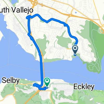
Experience this relatively short loop around the southwestern part of Vallejo and east end of Benicia.
The trip stages at the new and contravercial Glen Cove Waterfront Park, where you'll ride one of the newest stretches of the SF Bay Trail, a loosely paved/tightly packed gravel path along the western end of the park, turning south toward Benicia State Recreational Park.
Near the end of the paved road, you'll merge onto a dirt path leading into the State Park, where you'll climb a few hills in a northeast direction, eventually riding the flat, paved Dillon Point Road along Southampton Bay.
Once you reach the main entrance to the park, you'll cross the new cycle overpass over I-780 and begin to return to Glen Cove via. Columbus Parkway and Benicia Road.
Turning left onto Glen Cove Parkway, you continue your steady climb along the bike path, before going completely downhill all the way back to where you started.
- -:--
- Duración
- 8,6 km
- Distancia
- 144 m
- Ascenso
- 142 m
- Descenso
- ---
- Velocidad Media
- ---
- Altitud máxima
Calidad de la ruta
Tipos de vía y superficies a lo largo de la ruta
Tipos de vía
Carretera concurrida
3,7 km
(43 %)
Carril bici
1,8 km
(21 %)
Superficies
Pavimentado
2,1 km
(24 %)
Sin pavimentar
0,9 km
(10 %)
Asfalto
1,5 km
(17 %)
Hormigón
0,5 km
(6 %)
Continuar con Bikemap
Usa, edita o descarga esta ruta en bici
¿Te gustaría recorrer Glen Cove Loop o personalizarla para tu propio viaje? Esto es lo que puedes hacer con esta ruta de Bikemap:
Funciones gratuitas
- Guarda esta ruta como favorita o en una colección
- Copia y planifica tu propia versión de esta ruta
- Sincroniza tu ruta con Garmin o Wahoo
Funciones Premium
Prueba gratuita de 3 días o pago único. Más información sobre Bikemap Premium.
- Navega esta ruta en iOS y Android
- Exporta un archivo GPX / KML de esta ruta
- Crea tu impresión personalizada (pruébala gratis)
- Descarga esta ruta para la navegación sin conexión
Descubre más funciones Premium.
Consigue Bikemap PremiumDe nuestra comunidad
Crockett: Otras rutas populares que empiezan aquí
 Journey
- Distancia
- 26,7 km
- Ascenso
- 609 m
- Descenso
- 610 m
- Ubicación
- Crockett, California, Estados Unidos
 Martinez Loop
- Distancia
- 38 km
- Ascenso
- 334 m
- Descenso
- 345 m
- Ubicación
- Crockett, California, Estados Unidos
 Blistering ride in Benicia
- Distancia
- 55,3 km
- Ascenso
- 5 m
- Descenso
- 40 m
- Ubicación
- Crockett, California, Estados Unidos
 McEwen Rd
- Distancia
- 0,9 km
- Ascenso
- 106 m
- Descenso
- 0 m
- Ubicación
- Crockett, California, Estados Unidos
 Greenmont Drive 1101, Vallejo to Greenmont Drive 1031, Vallejo
- Distancia
- 77,4 km
- Ascenso
- 1032 m
- Descenso
- 1032 m
- Ubicación
- Crockett, California, Estados Unidos
 Bailey St, Vallejo to 1212 Wanda St, Crockett
- Distancia
- 9,4 km
- Ascenso
- 0 m
- Descenso
- 7 m
- Ubicación
- Crockett, California, Estados Unidos
 Glen Cove Loop
- Distancia
- 8,6 km
- Ascenso
- 144 m
- Descenso
- 142 m
- Ubicación
- Crockett, California, Estados Unidos
 Part 2 Crockett Ride
- Distancia
- 24,8 km
- Ascenso
- 247 m
- Descenso
- 328 m
- Ubicación
- Crockett, California, Estados Unidos
Ábrela en la app