
Santa Barbara / Montecito foothills loop CLONED FROM ROUTE 552049
Una ruta en bici que comienza en Mission Canyon, California, Estados Unidos.
Visión General
Sobre esta ruta
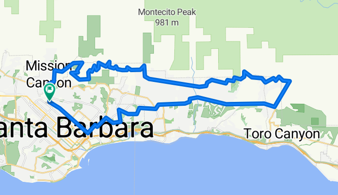
Esta ruta aprovecha todas las principales carreteras pavimentadas en la zona de Santa Bárbara que siguen las estribaciones. La parte de las estribaciones del circuito tiene poco tráfico de coches, ofrece vistas fantásticas y una buena variedad de pendientes.
Se recomienda la dirección en sentido horario, principalmente debido a la exigente pendiente de Toro Canyon Rd y al comienzo oriental de Viola Ln, ridículamente empinado aunque corto. Planea esforzarte subiendo Las Canoas Rd hasta Skofield Park, luego por Park Lane y Bella Vista, y finalmente en un par de secciones empinadas en Viola Ln. El resto es moderado.
Un par de advertencias: (1) A pesar de lo que muestra Google Maps, East Mountain Dr termina poco después de San Ysidro Ln porque está bloqueado por el resort privado San Ysidro Ranch. Sin embargo, es posible pedalear a través del resort: solo sigue el camino pavimentado con piedra. (2) La Viola Lane, de propiedad privada, no está bien señalizada en ninguno de los extremos. Busca un grupo de buzones negros poco después de que la sinuosa Bella Vista Drive se convierta en la recta Ladera Lane.
- -:--
- Duración
- 42,4 km
- Distancia
- 715 m
- Ascenso
- 715 m
- Descenso
- ---
- Velocidad Media
- ---
- Altitud máxima
Continuar con Bikemap
Usa, edita o descarga esta ruta en bici
¿Te gustaría recorrer Santa Barbara / Montecito foothills loop CLONED FROM ROUTE 552049 o personalizarla para tu propio viaje? Esto es lo que puedes hacer con esta ruta de Bikemap:
Funciones gratuitas
- Guarda esta ruta como favorita o en una colección
- Copia y planifica tu propia versión de esta ruta
- Sincroniza tu ruta con Garmin o Wahoo
Funciones Premium
Prueba gratuita de 3 días o pago único. Más información sobre Bikemap Premium.
- Navega esta ruta en iOS y Android
- Exporta un archivo GPX / KML de esta ruta
- Crea tu impresión personalizada (pruébala gratis)
- Descarga esta ruta para la navegación sin conexión
Descubre más funciones Premium.
Consigue Bikemap PremiumDe nuestra comunidad
Mission Canyon: Otras rutas populares que empiezan aquí
 Santa Barbara / Montecito foothills loop CLONED FROM ROUTE 552049
- Distancia
- 42,4 km
- Ascenso
- 715 m
- Descenso
- 715 m
- Ubicación
- Mission Canyon, California, Estados Unidos
 Santa Barbara Thirty
- Distancia
- 48,5 km
- Ascenso
- 423 m
- Descenso
- 423 m
- Ubicación
- Mission Canyon, California, Estados Unidos
 La Cumbre
- Distancia
- 49,5 km
- Ascenso
- 1311 m
- Descenso
- 1313 m
- Ubicación
- Mission Canyon, California, Estados Unidos
 4100–4136 Lago Dr, Santa Barbara to 2201 Laguna St, Santa Barbara
- Distancia
- 7 km
- Ascenso
- 97 m
- Descenso
- 55 m
- Ubicación
- Mission Canyon, California, Estados Unidos
 Santa Barbara Ridge Route
- Distancia
- 46,7 km
- Ascenso
- 1325 m
- Descenso
- 1317 m
- Ubicación
- Mission Canyon, California, Estados Unidos
 DISSCH Santa Barbara - Las Vegas
- Distancia
- 567,8 km
- Ascenso
- 2681 m
- Descenso
- 2083 m
- Ubicación
- Mission Canyon, California, Estados Unidos
 Santa Barbara Big 32 miles
- Distancia
- 52,2 km
- Ascenso
- 694 m
- Descenso
- 700 m
- Ubicación
- Mission Canyon, California, Estados Unidos
 Elings Park Loop
- Distancia
- 16,6 km
- Ascenso
- 218 m
- Descenso
- 219 m
- Ubicación
- Mission Canyon, California, Estados Unidos
Ábrela en la app