

Limestone Mt. Loop
Una ruta en bici que comienza en Parsons, Virginia Occidental, Estados Unidos.
Visión General
Sobre esta ruta
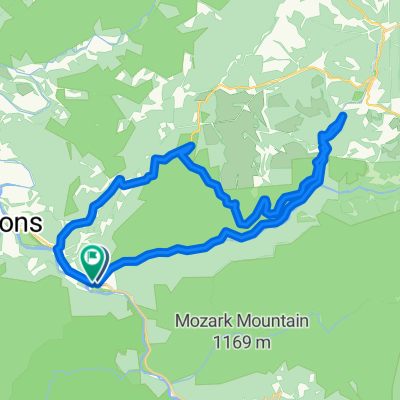
One long climb up Location Road, rolling across Limestone Mountain and then you descend back to the river at St. George. Don't let the first steep ramp out of St. George scare you. The climb is mostly 5-7% for the first 5 miles, then a little down grade the the last couple miles you have some 8-10% grades.
0.0 Start at the park by the river in St. George. Leaving the park you continue straight thru St. George and begin an immediate climb on Cty 5, Location Road.<br />
9.0 Left on Cty. 3.
13.0 Bare left. to stay on Limestone Rd. <br />
13.2 Cty. 3 right right. Stay straight to continue on what is now Cty. 1.
20.6 Right in St. George to return to Park.
20.8 Finish<br />
- -:--
- Duración
- 33,4 km
- Distancia
- 587 m
- Ascenso
- 587 m
- Descenso
- ---
- Velocidad Media
- ---
- Altitud máxima

Calidad de la ruta
Tipos de vía y superficies a lo largo de la ruta
Tipos de vía
Carretera tranquila
18,1 km
(54 %)
Carretera
15,3 km
(46 %)
Superficies
Sin pavimentar
6 km
(18 %)
Grava
6 km
(18 %)
Sin definir
27,4 km
(82 %)
Continuar con Bikemap
Usa, edita o descarga esta ruta en bici
¿Te gustaría recorrer Limestone Mt. Loop o personalizarla para tu propio viaje? Esto es lo que puedes hacer con esta ruta de Bikemap:
Funciones gratuitas
- Guarda esta ruta como favorita o en una colección
- Copia y planifica tu propia versión de esta ruta
- Sincroniza tu ruta con Garmin o Wahoo
Funciones Premium
Prueba gratuita de 3 días o pago único. Más información sobre Bikemap Premium.
- Navega esta ruta en iOS y Android
- Exporta un archivo GPX / KML de esta ruta
- Crea tu impresión personalizada (pruébala gratis)
- Descarga esta ruta para la navegación sin conexión
Descubre más funciones Premium.
Consigue Bikemap PremiumDe nuestra comunidad
Parsons: Otras rutas populares que empiezan aquí
 Texas Mountain
- Distancia
- 34,7 km
- Ascenso
- 502 m
- Descenso
- 502 m
- Ubicación
- Parsons, Virginia Occidental, Estados Unidos
 Parsons Radfahren
- Distancia
- 82,2 km
- Ascenso
- 946 m
- Descenso
- 923 m
- Ubicación
- Parsons, Virginia Occidental, Estados Unidos
 Backbone Mountain Climb
- Distancia
- 8,7 km
- Ascenso
- 534 m
- Descenso
- 26 m
- Ubicación
- Parsons, Virginia Occidental, Estados Unidos
 Olson Fire Tower to Parsons
- Distancia
- 35,8 km
- Ascenso
- 96 m
- Descenso
- 710 m
- Ubicación
- Parsons, Virginia Occidental, Estados Unidos
 Second St, Hendricks to Allegheny Highlands Trail of Wv, Hendricks
- Distancia
- 39,5 km
- Ascenso
- 798 m
- Descenso
- 794 m
- Ubicación
- Parsons, Virginia Occidental, Estados Unidos
 Limestone Mt. Loop
- Distancia
- 33,4 km
- Ascenso
- 587 m
- Descenso
- 587 m
- Ubicación
- Parsons, Virginia Occidental, Estados Unidos
 BW falls to Parsons to Deck Creek to apt
- Distancia
- 124,3 km
- Ascenso
- 959 m
- Descenso
- 1571 m
- Ubicación
- Parsons, Virginia Occidental, Estados Unidos
 Parsons-Montrose Loop
- Distancia
- 61,5 km
- Ascenso
- 604 m
- Descenso
- 602 m
- Ubicación
- Parsons, Virginia Occidental, Estados Unidos
Ábrela en la app