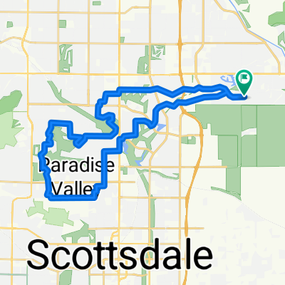
Tempe Loop
- 20,7 km
- 58 m
- 58 m
- Scottsdale, Arizona, Estados Unidos
Una ruta en bici que comienza en Scottsdale, Arizona, Estados Unidos.
Visión General
This is a beautiful bike route for a relaxed ride with hardly any street riding. Start at Chaparral Park parking lot at Jackrabbit Rd. Cross the street to the West side and head north (watch for signs directing bikers to under street routes rather than crossing at the street). Follow the greenbelt paving until you get to the canal. You will see the golf course parking lot and continue just past the parking lot and the club house to the paved route and turn left. This will run along the canal on the northwest side and head south. When the paving ends continue on the hardpack along the canal heading southabout 2 miles (this is the only section that is not paved). At Camelback Rd., turn right across Scottsdale Rd and then left across Camelback. Begin on the southside of the canal and follow the paved area until you reach 64th street. (Paving along the canal is under construction and should be completed by the summer of 2013.) Head south on 64th street along the east side of the canal. At Thaomas Rd. the canal takes an southeast anglular turn and follow the paved route. When you reach the rear of the Desert Botanical Garden Garden you will see 2 potential routes. (1 along the canal and 1 closer to the park) !st time you should stick with the canal route. Stay on the west side of the canal until the paving forces you to cross over to the east side of the canal. Take the 1st right to continue following the canal which turns into a stream (very pretty). Turn left at Mill Ave, right on Curry and then left on W. Lake View Dr. Go under the freeway and then onto the bike path heading east. (At this point we like to go into Tempe for lunch. If you do, go west instead, to go across the pedestrian bridge and make your way to the Mill Ave Shopping District.) Back on the bike path heading east along the freeway turn right at College Ave toward the lake and restrooms. Head east along the lake and eventually turning north to pick up the greenbelt again. (watch for signs directing bikers to under street routes rather than crossing at the street) Follow the bike route along the greenbelt, you can't get lost. After you pass Indian School Rd and go around the lake and meet up with Hayden take the underpass under Hayden to get to the east side and then head north back to the parking lot.
creado hace 12 años
Calidad de la ruta
Carril bici
21,8 km
(76 %)
Zona peatonal
4,9 km
(17 %)
Pavimentado
26,7 km
(93 %)
Sin pavimentar
1,1 km
(4 %)
Hormigón
24,4 km
(85 %)
Asfalto
2,3 km
(8 %)
Continuar con Bikemap
¿Te gustaría recorrer Tempe Lake-Scottsdale loop o personalizarla para tu propio viaje? Esto es lo que puedes hacer con esta ruta de Bikemap:
Prueba gratuita de 3 días o pago único. Más información sobre Bikemap Premium.
Descubre más funciones Premium.
Consigue Bikemap PremiumDe nuestra comunidad
Ábrela en la app