

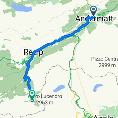
NL Rhine Cycle Route
Una ruta en bici que comienza en Andermatt, Uri, Suiza.
Visión General
Sobre esta ruta
La ruta ciclista del Rin tiene aproximadamente 1.360 kilómetros de longitud y atraviesa cinco países. El recorrido comienza en los Alpes suizos, la zona de nacimiento del Rin. Luego pasa por Austria, Francia y Alemania. La ruta termina en Róterdam, en los Países Bajos, donde el Rin desemboca en el Mar del Norte.
- -:--
- Duración
- 1365,4 km
- Distancia
- 12 m
- Ascenso
- 1447 m
- Descenso
- ---
- Velocidad Media
- ---
- Altitud máxima

Calidad de la ruta
Tipos de vía y superficies a lo largo de la ruta
Tipos de vía
Camino forestal
368,7 km
(27 %)
Carretera tranquila
286,7 km
(21 %)
Superficies
Pavimentado
887,5 km
(65 %)
Sin pavimentar
286,7 km
(21 %)
Asfalto
860,2 km
(63 %)
Grava
177,5 km
(13 %)
Destacados de la ruta
Puntos de interés a lo largo de la ruta

Punto de interés después de 299,4 km
The Rhine Falls (Rheinfall in German) is the largest plain waterfall in Europe. They are 150 m wide and 23 m high.

Punto de interés después de 675,2 km
Speyer is one of the oldest cities in Germany and is therefore historically and culturally important. Most famous is the Imperial Cathedral of Speyer.

Punto de interés después de 839,2 km
The Lorelei is a rock on the eastern bank of the Rhine which soars some 120 metres above the waterline. It marks the narrowest part of the river between Switzerland and the North Sea, and is the most famous feature of the Rhine Gorge, a 65 km section of the river between Koblenz and Bingen that was added to the UNESCO World Heritage Sites in June 2002. A very strong current and rocks below the waterline have caused many boat accidents there. Lorelei is also the name of a feminine water spirit, similar to mermaids or Rhine maidens, associated with this rock in popular folklore and in works of music, art and literature.

Punto de interés después de 903,5 km
One of Andernach's natural attractions is the world's highest (max. 64 m) cold-water geyser, driven by carbon dioxide with force generated in a fashion similar to that in a shaken bottle of table water.
Continuar con Bikemap
Usa, edita o descarga esta ruta en bici
¿Te gustaría recorrer NL Rhine Cycle Route o personalizarla para tu propio viaje? Esto es lo que puedes hacer con esta ruta de Bikemap:
Funciones gratuitas
- Guarda esta ruta como favorita o en una colección
- Copia y planifica tu propia versión de esta ruta
- Divídelo en etapas para crear una excursión de varios días
- Sincroniza tu ruta con Garmin o Wahoo
Funciones Premium
Prueba gratuita de 3 días o pago único. Más información sobre Bikemap Premium.
- Navega esta ruta en iOS y Android
- Exporta un archivo GPX / KML de esta ruta
- Crea tu impresión personalizada (pruébala gratis)
- Descarga esta ruta para la navegación sin conexión
Descubre más funciones Premium.
Consigue Bikemap PremiumDe nuestra comunidad
Andermatt: Otras rutas populares que empiezan aquí
 VR01 Furkapass Belvedere-Brig.kml - VR01 Furkapass Belvedere-Brig.kml_VR01 Furkapass Belvedere-Brig
- Distancia
- 60,1 km
- Ascenso
- 852 m
- Descenso
- 2409 m
- Ubicación
- Andermatt, Uri, Suiza
 NL The Rhine Cycle Route
- Distancia
- 1352,1 km
- Ascenso
- 88 m
- Descenso
- 1523 m
- Ubicación
- Andermatt, Uri, Suiza
 Rheinradweg
- Distancia
- 1085,7 km
- Ascenso
- 107 m
- Descenso
- 1544 m
- Ubicación
- Andermatt, Uri, Suiza
 Witenwasseren Bike
- Distancia
- 17,3 km
- Ascenso
- 808 m
- Descenso
- 26 m
- Ubicación
- Andermatt, Uri, Suiza
 Rhine Cycle Route, EuroVelo 15 - Andermatt to Basel
- Distancia
- 492,2 km
- Ascenso
- 6424 m
- Descenso
- 7590 m
- Ubicación
- Andermatt, Uri, Suiza
 Andermatt 3
- Distancia
- 158,9 km
- Ascenso
- 3905 m
- Descenso
- 3702 m
- Ubicación
- Andermatt, Uri, Suiza
 Transalpine (7) Andermatt - Visp
- Distancia
- 89,5 km
- Ascenso
- 1685 m
- Descenso
- 2290 m
- Ubicación
- Andermatt, Uri, Suiza
 Furka-Nufenen-Gotthard-Oberalp
- Distancia
- 135,9 km
- Ascenso
- 4637 m
- Descenso
- 4527 m
- Ubicación
- Andermatt, Uri, Suiza
Ábrela en la app