

Tissington and High Peak Trails (and the roady thing to join up the ends)
Una ruta en bici que comienza en Ashbourne, Inglaterra, Reino Unido.
Visión General
Sobre esta ruta
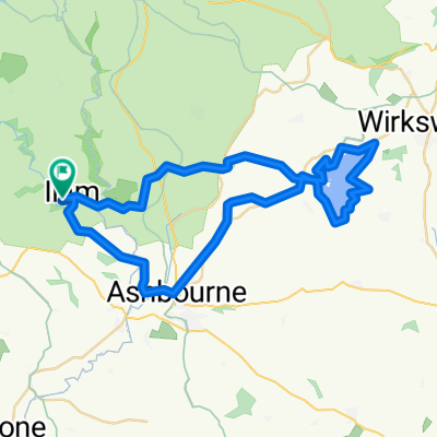
Empecé en Ashbourne, subiendo por el sendero Tissington que tiene una pendiente muy, muy ligera, bastante molesta durante los primeros cinco millas. Luego se suaviza y el resto es completamente plano, con muchas áreas de descanso pequeñas, incluido Hartington Signal Box. Hasta Parsley Hay, haces un giro de 180 grados y vuelves por el High Peak Trail que es igualmente plano y con buen pavimento. Dos pendientes cerca del final de Cromford, ambas a favor del ciclista en esta dirección! Cerca del final de la segunda pendiente, me caigo del sendero hacia la derecha y tomo las carreteras para el último tramo de regreso a Ashbourne - mucho más montañoso (un par de bonitas bajadas) y los conductores son unos idiotas. Un par de pubs si te interesa....
- -:--
- Duración
- 55,6 km
- Distancia
- 437 m
- Ascenso
- 437 m
- Descenso
- ---
- Velocidad Media
- ---
- Altitud máxima

Calidad de la ruta
Tipos de vía y superficies a lo largo de la ruta
Tipos de vía
Carril bici
40,6 km
(73 %)
Ruta
1,1 km
(2 %)
Superficies
Pavimentado
5,6 km
(10 %)
Sin pavimentar
40 km
(72 %)
Grava
40 km
(72 %)
Asfalto
5,6 km
(10 %)
Sin definir
10 km
(18 %)
Continuar con Bikemap
Usa, edita o descarga esta ruta en bici
¿Te gustaría recorrer Tissington and High Peak Trails (and the roady thing to join up the ends) o personalizarla para tu propio viaje? Esto es lo que puedes hacer con esta ruta de Bikemap:
Funciones gratuitas
- Guarda esta ruta como favorita o en una colección
- Copia y planifica tu propia versión de esta ruta
- Sincroniza tu ruta con Garmin o Wahoo
Funciones Premium
Prueba gratuita de 3 días o pago único. Más información sobre Bikemap Premium.
- Navega esta ruta en iOS y Android
- Exporta un archivo GPX / KML de esta ruta
- Crea tu impresión personalizada (pruébala gratis)
- Descarga esta ruta para la navegación sin conexión
Descubre más funciones Premium.
Consigue Bikemap PremiumDe nuestra comunidad
Ashbourne: Otras rutas populares que empiezan aquí
 Route 10 Carsington Water circular
- Distancia
- 43,6 km
- Ascenso
- 513 m
- Descenso
- 514 m
- Ubicación
- Ashbourne, Inglaterra, Reino Unido
 Tissington and High Peak Trails (and the roady thing to join up the ends)
- Distancia
- 55,6 km
- Ascenso
- 437 m
- Descenso
- 437 m
- Ubicación
- Ashbourne, Inglaterra, Reino Unido
 C38.5 WPC
- Distancia
- 62,3 km
- Ascenso
- 355 m
- Descenso
- 357 m
- Ubicación
- Ashbourne, Inglaterra, Reino Unido
 Milldale - Hall Dale Walk
- Distancia
- 10,5 km
- Ascenso
- 247 m
- Descenso
- 248 m
- Ubicación
- Ashbourne, Inglaterra, Reino Unido
 ride in the peak district
- Distancia
- 50,1 km
- Ascenso
- 723 m
- Descenso
- 723 m
- Ubicación
- Ashbourne, Inglaterra, Reino Unido
 09.2018 Cov-M'cr-Cov. Dzien 2/3
- Distancia
- 59,4 km
- Ascenso
- 491 m
- Descenso
- 783 m
- Ubicación
- Ashbourne, Inglaterra, Reino Unido
 tissington trail to high peak trail
- Distancia
- 12,9 km
- Ascenso
- 219 m
- Descenso
- 159 m
- Ubicación
- Ashbourne, Inglaterra, Reino Unido
 Flashy Manifold Trail
- Distancia
- 77,5 km
- Ascenso
- 1186 m
- Descenso
- 1187 m
- Ubicación
- Ashbourne, Inglaterra, Reino Unido
Ábrela en la app